

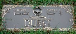
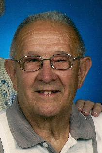
Clifford James Durst
| Birth | : | 23 May 1936 Spencer, Clay County, Iowa, USA |
| Death | : | 28 Jan 2014 Spencer, Clay County, Iowa, USA |
| Burial | : | North Lawn Cemetery, Spencer, Clay County, USA |
| Coordinate | : | 43.1600000, -95.1470000 |
| Description | : | Clifford James Durst, the son of Balthasar and Helen Gutknecht Durst was born May 23, 1936 in Spencer. He received his early education and graduated from the Spencer High School in 1954. Clifford served in the Iowa National Guard from 1954 to 1962. Clifford married Ardell Wiemers on November 18, 1959. They live in Spencer and in 1966 moved to the Durst family farm in Langdon, which was named a Century Farm in 2013. Clifford worked at Spencer Foods for 17 years and then worked for various trucking companies; during this time he was also engaged in farming and raising livestock.... Read More |
frequently asked questions (FAQ):
-
Where is Clifford James Durst's memorial?
Clifford James Durst's memorial is located at: North Lawn Cemetery, Spencer, Clay County, USA.
-
When did Clifford James Durst death?
Clifford James Durst death on 28 Jan 2014 in Spencer, Clay County, Iowa, USA
-
Where are the coordinates of the Clifford James Durst's memorial?
Latitude: 43.1600000
Longitude: -95.1470000
Family Members:
Parent

Siblings

Flowers:


Nearby Cemetories:
1. North Lawn Cemetery
Spencer, Clay County, USA
Coordinate: 43.1600000, -95.1470000
2. Dewey Readmore Books Memorial
Spencer, Clay County, USA
Coordinate: 43.1403999, -95.1443024
3. Riverside Cemetery
Spencer, Clay County, USA
Coordinate: 43.1441994, -95.1671982
4. Fairview Cemetery
Clay County, USA
Coordinate: 43.1899986, -95.0800018
5. Evergreen Cemetery
Clay County, USA
Coordinate: 43.2052994, -95.2086029
6. Dickens Cemetery
Dickens, Clay County, USA
Coordinate: 43.1280000, -95.0155000
7. Swedish Lutheran Cemetery
Royal, Clay County, USA
Coordinate: 43.0683000, -95.2350000
8. Little Sioux Lutheran Cemetery
Milford, Dickinson County, USA
Coordinate: 43.2702065, -95.2109528
9. Rosehill Cemetery
Clay County, USA
Coordinate: 43.0368996, -95.0919037
10. First Reformed Cemetery
Clay County, USA
Coordinate: 43.2399500, -95.2889000
11. Lone Tree Cemetery
Everly, Clay County, USA
Coordinate: 43.1411018, -95.3347015
12. Milford Cemetery
Milford, Dickinson County, USA
Coordinate: 43.3092003, -95.1481018
13. Lincoln Cemetery
Rossie, Clay County, USA
Coordinate: 43.0111008, -95.2313995
14. Calvary Cemetery
Milford, Dickinson County, USA
Coordinate: 43.3213997, -95.1688995
15. Logan Township Cemetery
Clay County, USA
Coordinate: 43.0489006, -94.9747009
16. Liberty Cemetery
Greenville, Clay County, USA
Coordinate: 42.9897003, -95.1417007
17. Willow Creek Cemetery
Royal, Clay County, USA
Coordinate: 43.0214005, -95.2885971
18. Clay Center Cemetery
Royal, Clay County, USA
Coordinate: 43.0410995, -95.3272018
19. TriMello Cemetery
Royal, Clay County, USA
Coordinate: 43.0682983, -95.3728027
20. Crown Hill Cemetery
Ruthven, Palo Alto County, USA
Coordinate: 43.1328011, -94.8878021
21. Calvary Cemetery
Ruthven, Palo Alto County, USA
Coordinate: 43.1314011, -94.8869019
22. Zion Methodist Cemetery
Clay County, USA
Coordinate: 42.9808006, -95.2497025
23. Westport Cemetery
Dickinson County, USA
Coordinate: 43.3130989, -95.3289032
24. Okoboji Cemetery
Arnolds Park, Dickinson County, USA
Coordinate: 43.3649406, -95.1303558