

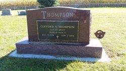
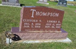
Clifford Virgil “Cliff” Thompson
| Birth | : | 9 Dec 1924 Van Horne, Benton County, Iowa, USA |
| Death | : | 2 Jan 2014 Keystone, Benton County, Iowa, USA |
| Burial | : | Salem Cemetery, Van Horne, Benton County, USA |
| Coordinate | : | 41.9928017, -92.0421982 |
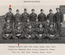
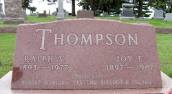
| Description | : | Age 89, died Thursday, at the Keystone Nursing Care Center following an extended illness. Cliff was born in rural Van Horne to Ralph and Joy (Rieke) Thompson. He was baptized May 29, 1927 and confirmed April 4, 1950. He graduated from Van Horne High School in 1942. Cliff served his Country in the United States Army in the 78th Lightning Division during World War II. He was united in marriage to Lenore Schminke on August 7, 1949 and enjoyed sixty-three years of marriage. Lenore preceded Cliff in death on November 26, 2012. He... Read More |
frequently asked questions (FAQ):
-
Where is Clifford Virgil “Cliff” Thompson's memorial?
Clifford Virgil “Cliff” Thompson's memorial is located at: Salem Cemetery, Van Horne, Benton County, USA.
-
When did Clifford Virgil “Cliff” Thompson death?
Clifford Virgil “Cliff” Thompson death on 2 Jan 2014 in Keystone, Benton County, Iowa, USA
-
Where are the coordinates of the Clifford Virgil “Cliff” Thompson's memorial?
Latitude: 41.9928017
Longitude: -92.0421982
Family Members:
Parent

Spouse
Siblings
Flowers:


Nearby Cemetories:
1. Salem Cemetery
Van Horne, Benton County, USA
Coordinate: 41.9928017, -92.0421982
2. Saint Johns Lutheran Cemetery
Newhall, Benton County, USA
Coordinate: 41.9933014, -92.0093994
3. Prairie Cemetery
Van Horne, Benton County, USA
Coordinate: 41.9626440, -92.0282390
4. Calvary Cemetery
Van Horne, Benton County, USA
Coordinate: 41.9641991, -92.1138992
5. Wagner Cemetery
Newhall, Benton County, USA
Coordinate: 41.9848870, -91.9420910
6. Van Metre Cemetery
Keystone, Benton County, USA
Coordinate: 41.9614983, -92.1514969
7. Bellar-Eden Cemetery
Vinton, Benton County, USA
Coordinate: 42.0803000, -92.0470500
8. Fix Cemetery
Atkins, Benton County, USA
Coordinate: 42.0194431, -91.9251814
9. Bender Cemetery
Keystone, Benton County, USA
Coordinate: 42.0363998, -92.1536026
10. LaRue Cemetery
Benton County, USA
Coordinate: 42.0574989, -92.1438980
11. Holy Cross Cemetery
Keystone, Benton County, USA
Coordinate: 41.9961014, -92.1825027
12. Raetz Cemetery
Atkins, Benton County, USA
Coordinate: 41.9928017, -91.8977966
13. Saint Patricks and Saint Pauls Cemetery
Watkins, Benton County, USA
Coordinate: 41.8986800, -91.9728000
14. Mound Cemetery
Watkins, Benton County, USA
Coordinate: 41.8972015, -91.9713974
15. Pleasant Hill Cemetery
Blairstown, Benton County, USA
Coordinate: 41.8874630, -92.0836900
16. Ranstead Cemetery
Luzerne, Benton County, USA
Coordinate: 41.9201622, -92.1613846
17. Saint Michael's Cemetery
Norway, Benton County, USA
Coordinate: 41.9091988, -91.9263992
18. Norway Cemetery
Benton County, USA
Coordinate: 41.9093300, -91.9256200
19. Indian Cemetery
Garrison, Benton County, USA
Coordinate: 42.0999956, -92.1168495
20. Big Grove Cemetery
Benton County, USA
Coordinate: 42.1088982, -92.0867004
21. Parkers Grove Cemetery
Shellsburg, Benton County, USA
Coordinate: 42.0555992, -91.9028015
22. East-Eden Cemetery
Eden, Benton County, USA
Coordinate: 42.1091995, -91.9841995
23. Saint Stephens Lutheran Cemetery
Atkins, Benton County, USA
Coordinate: 41.9814987, -91.8720016
24. Keystone Cemetery
Keystone, Benton County, USA
Coordinate: 41.9939003, -92.2172012