
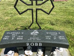
Clifford William “Bill” Robb
| Birth | : | 21 Nov 1936 Arapahoe, Furnas County, Nebraska, USA |
| Death | : | 3 Dec 2018 Elwood, Gosper County, Nebraska, USA |
| Burial | : | Elwood Cemetery, Elwood, Gosper County, USA |
| Coordinate | : | 40.5999300, -99.8397300 |
| Description | : | Clifford William “Bill” Robb, age 82, of Elwood, Nebraska died Monday, December 3, 2018, at his home. He was born November 22, 1936 in Arapahoe, Nebraska to Melvin Clifford and Viola Mae (Shellenbarger) Robb. On August 23, 1957, he married Winona Seevers at Elwood and to this union two children were born; Bill and Robin. They moved to Lexington where Bill worked construction for T.L. Sund. Later he would work for Cornland Beef, Excel, and IBP meat processing. He would also work for DeBoer Brothers at their alcohol plant. They would move to Elwood, Nebraska in February of... Read More |
frequently asked questions (FAQ):
-
Where is Clifford William “Bill” Robb's memorial?
Clifford William “Bill” Robb's memorial is located at: Elwood Cemetery, Elwood, Gosper County, USA.
-
When did Clifford William “Bill” Robb death?
Clifford William “Bill” Robb death on 3 Dec 2018 in Elwood, Gosper County, Nebraska, USA
-
Where are the coordinates of the Clifford William “Bill” Robb's memorial?
Latitude: 40.5999300
Longitude: -99.8397300
Family Members:
Parent
Spouse

Flowers:


Nearby Cemetories:
1. Elwood Cemetery
Elwood, Gosper County, USA
Coordinate: 40.5999300, -99.8397300
2. Quakerville Cemetery
Gosper County, USA
Coordinate: 40.6189003, -99.8097000
3. Hope Lutheran Cemetery
Smithfield, Gosper County, USA
Coordinate: 40.5667500, -99.6800000
4. Robb Cemetery
Smithfield, Gosper County, USA
Coordinate: 40.6710691, -99.6996001
5. Homerville Cemetery
Gosper County, USA
Coordinate: 40.4668999, -99.8593979
6. Pioneer Cemetery
Eustis, Frontier County, USA
Coordinate: 40.6632810, -100.0013730
7. Keely Cemetery
Smithfield, Gosper County, USA
Coordinate: 40.5727500, -99.6563500
8. Fairfield Cemetery
Gosper County, USA
Coordinate: 40.4672012, -99.7549973
9. Salem East Cemetery
Gosper County, USA
Coordinate: 40.4972000, -99.9803009
10. Pleasant Grove Cemetery
Gosper County, USA
Coordinate: 40.4664001, -99.9250031
11. Salem West Cemetery
Frontier County, USA
Coordinate: 40.4968987, -99.9886017
12. Eustis East Cemetery
Eustis, Frontier County, USA
Coordinate: 40.6714100, -100.0199780
13. Yoder Cemetery
Smithfield, Gosper County, USA
Coordinate: 40.4957000, -99.6845500
14. McGuire Cemetery
Gosper County, USA
Coordinate: 40.4380989, -99.8664017
15. Immanuel Cemetery
Bertrand, Phelps County, USA
Coordinate: 40.5682983, -99.6283035
16. Westview Cemetery
Eustis, Frontier County, USA
Coordinate: 40.6708740, -100.0380710
17. Evergreen Cemetery
Frontier County, USA
Coordinate: 40.5689011, -100.0571976
18. Highland Cemetery
Bertrand, Phelps County, USA
Coordinate: 40.5194016, -99.6430969
19. Immanuel Lutheran Cemetery
Elwood, Gosper County, USA
Coordinate: 40.4206500, -99.8672000
20. Plum Creek Massacre Cemetery
Phelps County, USA
Coordinate: 40.6726840, -99.6058220
21. Adullam Cemetery
Bertrand, Phelps County, USA
Coordinate: 40.6265000, -99.5856000
22. First United Methodist Church Columbarium
Lexington, Dawson County, USA
Coordinate: 40.7810000, -99.7397000
23. Saint Anns Cemetery
Lexington, Dawson County, USA
Coordinate: 40.7789001, -99.7114029
24. Evergreen Cemetery
Lexington, Dawson County, USA
Coordinate: 40.7639008, -99.6791992