
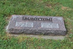
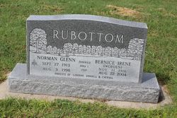
Clora Belle Cooper Rubottom
| Birth | : | 12 Aug 1890 Rooks County, Kansas, USA |
| Death | : | 23 Dec 1967 Plainville, Rooks County, Kansas, USA |
| Burial | : | Woodston Cemetery, Woodston, Rooks County, USA |
| Coordinate | : | 39.4375000, -99.1268997 |
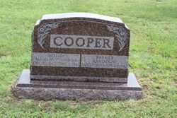
| Description | : | Obituary: CLOA BELLE RUBOTTOM Cloa Belle Rubottom, second child of Maud and Randolph Cooper was born in Woodston on August 12, 1890 and departed this life Dec. 23, 1967. Cloa's early life was spent on a farm south of Woodston. Her parents having moved there when she was 9 years old. After her marriage in 1912 to Lester Rubottom they made their home with his parents on a farm only 3 miles from her girlhood home. In 1915 they built a new home on Rubottom land where they lived until Sept. 1965 when they moved to Stockton. Four children came to bless... Read More |
frequently asked questions (FAQ):
-
Where is Clora Belle Cooper Rubottom's memorial?
Clora Belle Cooper Rubottom's memorial is located at: Woodston Cemetery, Woodston, Rooks County, USA.
-
When did Clora Belle Cooper Rubottom death?
Clora Belle Cooper Rubottom death on 23 Dec 1967 in Plainville, Rooks County, Kansas, USA
-
Where are the coordinates of the Clora Belle Cooper Rubottom's memorial?
Latitude: 39.4375000
Longitude: -99.1268997
Family Members:
Parent

Spouse

Siblings

Children
Flowers:


Nearby Cemetories:
1. Woodston Cemetery
Woodston, Rooks County, USA
Coordinate: 39.4375000, -99.1268997
2. Survey Cemetery
Woodston, Rooks County, USA
Coordinate: 39.3722000, -99.1333008
3. Spring Branch Cemetery
Woodston, Rooks County, USA
Coordinate: 39.5099983, -99.0580978
4. West Hope Cemetery
Rooks County, USA
Coordinate: 39.5024986, -99.2110977
5. Ash Rock Cemetery
Woodston, Rooks County, USA
Coordinate: 39.5248909, -99.0817719
6. Pleasant Valley Cemetery
Osborne County, USA
Coordinate: 39.4583015, -99.0077972
7. Johnson Cemetery
Stockton, Rooks County, USA
Coordinate: 39.3493996, -99.1941986
8. Stockton Cemetery
Stockton, Rooks County, USA
Coordinate: 39.4406700, -99.2647400
9. Saint Thomas Cemetery
Stockton, Rooks County, USA
Coordinate: 39.4449997, -99.2771988
10. Chalk Mound Cemetery
Laton, Rooks County, USA
Coordinate: 39.3208008, -99.0852966
11. Pleasant Plain Cemetery
Osborne County, USA
Coordinate: 39.3367004, -99.0372009
12. Pioneer Cemetery
Alton, Osborne County, USA
Coordinate: 39.4742012, -98.9749985
13. Mount Ayr Cemetery
Alton, Osborne County, USA
Coordinate: 39.3764000, -98.9717026
14. Old Stockton Cemetery
Stockton, Rooks County, USA
Coordinate: 39.4597015, -99.3050003
15. Bigge Family Cemetery
Stockton, Rooks County, USA
Coordinate: 39.4584700, -99.3053200
16. Grant Center Cemetery
Alton, Osborne County, USA
Coordinate: 39.5242004, -98.9708023
17. Sumner Cemetery
Alton, Osborne County, USA
Coordinate: 39.4799995, -98.9338913
18. Pleasant Ridge Cemetery
Kirwin, Phillips County, USA
Coordinate: 39.5963000, -99.1234000
19. Aurora Cemetery
Laton, Rooks County, USA
Coordinate: 39.2778015, -99.0847015
20. Greenwood Cemetery
Kirwin, Phillips County, USA
Coordinate: 39.5931900, -99.2064600
21. Bow Creek Cemetery
Glade, Phillips County, USA
Coordinate: 39.5681000, -99.2696991
22. Twin Mound Cemetery
Rooks County, USA
Coordinate: 39.2855988, -99.2319031
23. Kill Creek Cemetery
Alton, Osborne County, USA
Coordinate: 39.3805528, -98.8967658
24. Leasburg Cemetery
Cedar, Smith County, USA
Coordinate: 39.5819016, -98.9728012