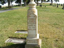
| Birth | : | 16 May 1865 |
| Death | : | 18 Aug 1914 |
| Burial | : | Harmony Grove Cemetery, Nebo, McDowell County, USA |
| Coordinate | : | 35.6653350, -81.9073650 |
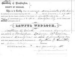
| Description | : | from FAG member Teresa: m: Mathias D Smith 7 Jan 1890 in Douglas Co, WA b: 16 May 1865 Canada d: 18 Aug 1914 in Seattle, King Co, WA daughter of Arch McLean and Mary A Noble |
frequently asked questions (FAQ):
-
Where is Colena N McLean Smith's memorial?
Colena N McLean Smith's memorial is located at: Harmony Grove Cemetery, Nebo, McDowell County, USA.
-
When did Colena N McLean Smith death?
Colena N McLean Smith death on 18 Aug 1914 in
-
Where are the coordinates of the Colena N McLean Smith's memorial?
Latitude: 35.6653350
Longitude: -81.9073650
Family Members:
Parent
Spouse
Siblings
Children
Flowers:
Nearby Cemetories:
1. Harmony Grove Cemetery
Nebo, McDowell County, USA
Coordinate: 35.6653350, -81.9073650
2. Bradley Family Cemetery - Nebo
McDowell County, USA
Coordinate: 35.6475900, -81.8999100
3. Hillcrest Cemetery
Nebo, McDowell County, USA
Coordinate: 35.6842850, -81.9070230
4. Living Waters Cemetery
McDowell County, USA
Coordinate: 35.6480160, -81.8956420
5. Rocky Pass Freewill Baptist Church Cemetery
Osborne Knob, McDowell County, USA
Coordinate: 35.6492004, -81.9255981
6. Dixon Cemetery
McDowell County, USA
Coordinate: 35.6507988, -81.8861008
7. Faith Mission Baptist Church Cemetery
McDowell County, USA
Coordinate: 35.6653820, -81.9352920
8. Old Tate Cemetery
McDowell County, USA
Coordinate: 35.6798630, -81.8800230
9. Fairview Freewill Baptist Church Cemetery
Nebo, McDowell County, USA
Coordinate: 35.6885680, -81.9265200
10. Revis Cemetery
McDowell County, USA
Coordinate: 35.6753740, -81.9410790
11. Pinnacle Methodist Church Cemetery
Nebo, McDowell County, USA
Coordinate: 35.6492200, -81.8747900
12. Muddy Creek Baptist
McDowell County, USA
Coordinate: 35.6871190, -81.8784670
13. Dysartsville Church of Christ Cemetery
Marion, McDowell County, USA
Coordinate: 35.6354600, -81.8890800
14. Hemphill Cemetery
McDowell County, USA
Coordinate: 35.7004480, -81.9014470
15. Pinnacle Baptist Church Cemetery
McDowell County, USA
Coordinate: 35.6984700, -81.8856700
16. Sunny Grove Baptist Church Cemetery
McDowell County, USA
Coordinate: 35.6271870, -81.8957620
17. Pleasant Hill United Methodist Church Cemetery
Marion, McDowell County, USA
Coordinate: 35.6677690, -81.9572040
18. Drucilla Independent Fundamental Cemetery
Dysartsville, McDowell County, USA
Coordinate: 35.6285700, -81.8821900
19. Solid Rock Free Will Baptist Church Cemetery
Marion, McDowell County, USA
Coordinate: 35.6693120, -81.9589280
20. Gardin-Haney Cemetery
McDowell County, USA
Coordinate: 35.6303270, -81.9400350
21. Haney Cemetery
McDowell County, USA
Coordinate: 35.6293983, -81.9400024
22. Saint John AME Church Cemetery
McDowell County, USA
Coordinate: 35.7058105, -81.8838196
23. Trinity Hill Freewill Baptist Church
McDowell County, USA
Coordinate: 35.7103500, -81.8955612
24. Salem Freewill Baptist Church Cemetery
Old Fort, McDowell County, USA
Coordinate: 35.7104460, -81.8954030


