
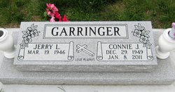
Connie June Warren Garringer
| Birth | : | 29 Dec 1949 Lexington, Dawson County, Nebraska, USA |
| Death | : | 8 Jan 2011 Kearney, Buffalo County, Nebraska, USA |
| Burial | : | Evergreen Cemetery, Lexington, Dawson County, USA |
| Coordinate | : | 40.7639008, -99.6791992 |
| Plot | : | DIV4. , BLOCK 224, LOT 3, AT THE FOOT OF SPACE 4. |
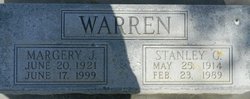
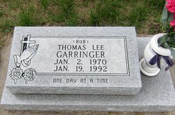
| Description | : | Connie June Garringer, 61 years of age, of Holdrege, passed away on Saturday, January 8, 2011 at the St. John's Good Samaritan Center in Kearney, Nebraska. Connie was born December 29, 1949 at Lexington, the second of three children of Stanley G. and Margery J. (Raetz) Warren. Connie received her education from Lexington Public Schools. Following her education, Connie was united in marriage to Jerry L. Garringer on February 14, 1966 at Elm Creek, Nebraska and to this union three children were born: Jeri, Thomas and Todd. After their marriage, Jerry and Connie made their home in Lexington, where Connie... Read More |
frequently asked questions (FAQ):
-
Where is Connie June Warren Garringer's memorial?
Connie June Warren Garringer's memorial is located at: Evergreen Cemetery, Lexington, Dawson County, USA.
-
When did Connie June Warren Garringer death?
Connie June Warren Garringer death on 8 Jan 2011 in Kearney, Buffalo County, Nebraska, USA
-
Where are the coordinates of the Connie June Warren Garringer's memorial?
Latitude: 40.7639008
Longitude: -99.6791992
Family Members:
Parent

Spouse

Children
Flowers:


Nearby Cemetories:
1. Evergreen Cemetery
Lexington, Dawson County, USA
Coordinate: 40.7639008, -99.6791992
2. Saint Anns Cemetery
Lexington, Dawson County, USA
Coordinate: 40.7789001, -99.7114029
3. First United Methodist Church Columbarium
Lexington, Dawson County, USA
Coordinate: 40.7810000, -99.7397000
4. Greenwood Cemetery
Lexington, Dawson County, USA
Coordinate: 40.7956467, -99.7286682
5. Mount Hope Cemetery
Dawson County, USA
Coordinate: 40.8293991, -99.6733017
6. Robb Cemetery
Smithfield, Gosper County, USA
Coordinate: 40.6710691, -99.6996001
7. Plum Creek Massacre Cemetery
Phelps County, USA
Coordinate: 40.6726840, -99.6058220
8. Hewitt Cemetery
Lexington, Dawson County, USA
Coordinate: 40.8588982, -99.7769012
9. Overton Cemetery
Overton, Dawson County, USA
Coordinate: 40.7317009, -99.5222015
10. Hillside Cemetery
Dawson County, USA
Coordinate: 40.8946991, -99.7869034
11. Adullam Cemetery
Bertrand, Phelps County, USA
Coordinate: 40.6265000, -99.5856000
12. Buffalo Grove Presbyterian Church Cemetery
Buffalo, Dawson County, USA
Coordinate: 40.8721000, -99.8270000
13. Grace Cemetery
Cozad, Dawson County, USA
Coordinate: 40.8602982, -99.8644028
14. Quakerville Cemetery
Gosper County, USA
Coordinate: 40.6189003, -99.8097000
15. Platte Valley Cemetery
Phelps County, USA
Coordinate: 40.6425018, -99.5028000
16. Sandstrom Cemetery
Phelps County, USA
Coordinate: 40.5983009, -99.5661011
17. Saint Johns Lutheran Cemetery
Lexington, Dawson County, USA
Coordinate: 40.9019012, -99.8458023
18. Keely Cemetery
Smithfield, Gosper County, USA
Coordinate: 40.5727500, -99.6563500
19. Hope Lutheran Cemetery
Smithfield, Gosper County, USA
Coordinate: 40.5667500, -99.6800000
20. Immanuel Cemetery
Bertrand, Phelps County, USA
Coordinate: 40.5682983, -99.6283035
21. Elwood Cemetery
Elwood, Gosper County, USA
Coordinate: 40.5999300, -99.8397300
22. Williamsburg Cemetery
Phelps County, USA
Coordinate: 40.6490290, -99.4543150
23. Jewell Cemetery
Sumner, Dawson County, USA
Coordinate: 40.9599991, -99.5646973
24. Saint Patricks Cemetery
Eddyville, Dawson County, USA
Coordinate: 40.9747009, -99.6093979