

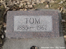
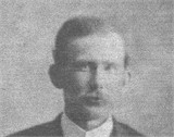
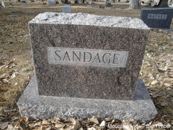
Corey “Tom” Sandage
| Birth | : | 4 Mar 1885 Harrison County, Missouri, USA |
| Death | : | 15 May 1967 Big Timber, Sweet Grass County, Montana, USA |
| Burial | : | Cypress Memorial Gardens, Pine Bluff, Jefferson County, USA |
| Coordinate | : | 34.1230460, -91.9931700 |
| Plot | : | Section 6 Block 27 Lot 1 Grave 2 |
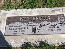
| Description | : | "Corey Tom Sandage, 82, a resident of Sweet Grass county for 62 years, passed away Monday morning at his home in Big Timber. He was born in Pawnee, Missouri, on March 4, 1885, the son of Jake and Harriet (Cronin) Sandage. He came to Sweet Grass country in 1905 and married Jennie Kamps March 22, 1909. He has ranched and lived most of the time in Big Timber and the surrounding area. Survivors include his widow; a son, Roy, of Salt Lake City; three daughters, Mrs. Floyd (Harriet) Nepstad, Mrs. Orville (Iris) Anderson, Mrs. Paul (Genevieve) Westervelt, all of Big... Read More |
frequently asked questions (FAQ):
-
Where is Corey “Tom” Sandage's memorial?
Corey “Tom” Sandage's memorial is located at: Cypress Memorial Gardens, Pine Bluff, Jefferson County, USA.
-
When did Corey “Tom” Sandage death?
Corey “Tom” Sandage death on 15 May 1967 in Big Timber, Sweet Grass County, Montana, USA
-
Where are the coordinates of the Corey “Tom” Sandage's memorial?
Latitude: 34.1230460
Longitude: -91.9931700
Family Members:
Parent
Spouse

Siblings

Children

Flowers:


Nearby Cemetories:
1. Cypress Memorial Gardens
Pine Bluff, Jefferson County, USA
Coordinate: 34.1230460, -91.9931700
2. Solomon Hill Cemetery
Jefferson County, USA
Coordinate: 34.1398920, -91.9887700
3. Jerman Cemetery
Pine Bluff, Jefferson County, USA
Coordinate: 34.1301080, -92.0289980
4. Bethel Church Cemetery
Melton Township, Jefferson County, USA
Coordinate: 34.1362719, -91.9513634
5. Harmony Missionary Baptist Church Cemetery
Jefferson County, USA
Coordinate: 34.0864660, -92.0102560
6. Burke's Place
Pine Bluff, Jefferson County, USA
Coordinate: 34.1664719, -91.9803975
7. Roselawn Memorial Garden
Pine Bluff, Jefferson County, USA
Coordinate: 34.0825005, -92.0224991
8. Bethel Cemetery
Pine Bluff, Jefferson County, USA
Coordinate: 34.1836014, -92.0042038
9. Parker Cemetery
Pine Bluff, Jefferson County, USA
Coordinate: 34.1806860, -92.0192120
10. Highline Cemetery
Pine Bluff, Jefferson County, USA
Coordinate: 34.1856200, -91.9802000
11. Canaan Cemetery
Lincoln County, USA
Coordinate: 34.0784030, -91.9363030
12. Mount Calvary Baptist Church Cemetery
Pine Bluff, Jefferson County, USA
Coordinate: 34.1907260, -91.9959910
13. Spring Hill Cemetery
Jefferson County, USA
Coordinate: 34.1610985, -92.0616989
14. Grace Memorial Garden
Pine Bluff, Jefferson County, USA
Coordinate: 34.1876270, -92.0232490
15. Bethany Chapel
Pine Bluff, Jefferson County, USA
Coordinate: 34.1815700, -91.9465360
16. Blackwell Hill Cemetery
Jefferson County, USA
Coordinate: 34.0960999, -92.0718994
17. New Saint Hurricane MBC Cemetery
Pine Bluff, Jefferson County, USA
Coordinate: 34.1948200, -91.9890300
18. Taylor Cemetery
Pine Bluff, Jefferson County, USA
Coordinate: 34.1953011, -91.9794006
19. Union Hopewell Cemetery
Pine Bluff, Jefferson County, USA
Coordinate: 34.1946770, -92.0332710
20. Good Faith Cemetery
Pine Bluff, Jefferson County, USA
Coordinate: 34.1907997, -92.0468979
21. Mount Zion Baptist Church Cemetery
Faith, Jefferson County, USA
Coordinate: 34.0858110, -92.0818130
22. Grahams Cemetery
Lincoln County, USA
Coordinate: 34.0567017, -91.9308014
23. Smith Chapel Cemetery
Jefferson County, USA
Coordinate: 34.1963997, -91.9428024
24. Smith Cemetery
Jefferson County, USA
Coordinate: 34.1397018, -91.8927994