
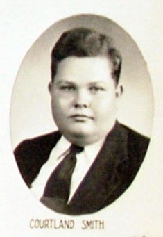

Courtland Shattuck “Corky” Smith
| Birth | : | 2 Nov 1929 |
| Death | : | 3 Aug 1968 |
| Burial | : | Paton Cemetery, Paton, Greene County, USA |
| Coordinate | : | 42.1624985, -94.2433014 |
| Inscription | : | Brother; The Lord Is My Shepherd I Shall Not Want |
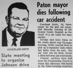
| Description | : | “Paton Mayor Dies Following Car Accident” Courtland Smith, 38, Paton mayor for the past six years, died Saturday morning at the Greene County Hospital as the result of a car crash two days earlier. Driving east from Paton on the county paved road Thursday morning, Smith reached down to pick up a transistor radio which had fallen from the seat. His car went into the ditch, struck a field driveway and overturned. Funeral services were held from the Presbyterian Church in Paton this afternoon with burial in the Paton Twp Cemetery. The Rev. Leo B. Wilson officiated.... Read More |
frequently asked questions (FAQ):
-
Where is Courtland Shattuck “Corky” Smith's memorial?
Courtland Shattuck “Corky” Smith's memorial is located at: Paton Cemetery, Paton, Greene County, USA.
-
When did Courtland Shattuck “Corky” Smith death?
Courtland Shattuck “Corky” Smith death on 3 Aug 1968 in
-
Where are the coordinates of the Courtland Shattuck “Corky” Smith's memorial?
Latitude: 42.1624985
Longitude: -94.2433014
Family Members:
Parent

Spouse

Siblings
Flowers:


Nearby Cemetories:
1. Paton Cemetery
Paton, Greene County, USA
Coordinate: 42.1624985, -94.2433014
2. Dawson Cemetery
Paton, Greene County, USA
Coordinate: 42.1655998, -94.3283005
3. Renner Cemetery
Boone County, USA
Coordinate: 42.1380420, -94.1256570
4. Lost Grove Cemetery
Harcourt, Webster County, USA
Coordinate: 42.2583008, -94.2331009
5. Swedish Lutheran Church Cemetery
Dayton, Webster County, USA
Coordinate: 42.2175000, -94.1065000
6. Lawn Cemetery
Boone County, USA
Coordinate: 42.1771011, -94.0867996
7. Union Cemetery
Boxholm, Boone County, USA
Coordinate: 42.1369019, -94.0852966
8. Grand Ridge Cemetery
Beaver, Boone County, USA
Coordinate: 42.0786018, -94.1157990
9. Gowrie Township Cemetery
Gowrie, Webster County, USA
Coordinate: 42.2813988, -94.3043976
10. Mount Calvary Cemetery
Grand Junction, Greene County, USA
Coordinate: 42.0266000, -94.2325000
11. Beaver Cemetery
Beaver, Boone County, USA
Coordinate: 42.0462000, -94.1446000
12. Junction Township Cemetery
Grand Junction, Greene County, USA
Coordinate: 42.0236015, -94.2593994
13. Maple Grove Cemetery
Boxholm, Boone County, USA
Coordinate: 42.0793690, -94.0859890
14. Maas Cemetery
Boone County, USA
Coordinate: 42.0908012, -94.0618973
15. Pilot Mound Cemetery
Pilot Mound, Boone County, USA
Coordinate: 42.1636200, -94.0282600
16. Christ the King Catholic Cemetery
Dayton, Webster County, USA
Coordinate: 42.2601929, -94.0727539
17. Dayton Cemetery
Dayton, Webster County, USA
Coordinate: 42.2675000, -94.0755000
18. Highland Township Cemetery
Churdan, Greene County, USA
Coordinate: 42.1518310, -94.4699120
19. Saint Joseph Cemetery
Jefferson, Greene County, USA
Coordinate: 42.0289001, -94.3818970
20. Reading Cemetery
Farnhamville, Calhoun County, USA
Coordinate: 42.2593994, -94.4325027
21. Jefferson Cemetery
Jefferson, Greene County, USA
Coordinate: 42.0133018, -94.3591995
22. Runyan Cemetery
Pilot Mound, Boone County, USA
Coordinate: 42.1749992, -94.0015030
23. Our Saviour Cemetery
Callender, Webster County, USA
Coordinate: 42.3396988, -94.3153000
24. Linn Cemetery
Pilot Mound, Boone County, USA
Coordinate: 42.2045330, -93.9970230