
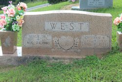
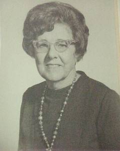
Cristeen Walker West
| Birth | : | 9 Sep 1931 |
| Death | : | 8 Jul 1974 Celina, Clay County, Tennessee, USA |
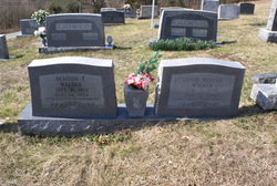
| Burial | : | Brockley and Ladywell Cemeteries, Lewisham, London Borough of Lewisham, England |
| Coordinate | : | 51.4570700, -0.0309400 |
| Inscription | : | Married Jan. 25, 1951 |
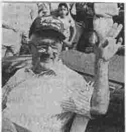
| Description | : | Age 42. She belonged to the Church of Christ and was a teacher. Wife of Leslie West, Jr. |
frequently asked questions (FAQ):
-
Where is Cristeen Walker West's memorial?
Cristeen Walker West's memorial is located at: Brockley and Ladywell Cemeteries, Lewisham, London Borough of Lewisham, England.
-
When did Cristeen Walker West death?
Cristeen Walker West death on 8 Jul 1974 in Celina, Clay County, Tennessee, USA
-
Where are the coordinates of the Cristeen Walker West's memorial?
Latitude: 51.4570700
Longitude: -0.0309400
Family Members:
Parent

Spouse

Siblings
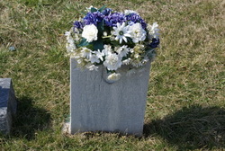
Flowers:


Nearby Cemetories:
1. Brockley and Ladywell Cemeteries
Lewisham, London Borough of Lewisham, England
Coordinate: 51.4570700, -0.0309400
2. Honor Oak Crematorium
Southwark, London Borough of Southwark, England
Coordinate: 51.4536111, -0.0436111
3. St. Mary the Virgin Churchyard
Lewisham, London Borough of Lewisham, England
Coordinate: 51.4556700, -0.0160400
4. Camberwell New Cemetery and Crematorium
Camberwell, London Borough of Southwark, England
Coordinate: 51.4534836, -0.0466380
5. St Augustine Churchyard
Forest Hill, London Borough of Lewisham, England
Coordinate: 51.4503260, -0.0508140
6. Nunhead Cemetery
Nunhead, London Borough of Southwark, England
Coordinate: 51.4642296, -0.0530430
7. Camberwell Old Cemetery
Camberwell, London Borough of Southwark, England
Coordinate: 51.4507866, -0.0586410
8. Old St. Margaret's Churchyard
Lee, London Borough of Lewisham, England
Coordinate: 51.4633010, 0.0001900
9. St. Margaret's of Antioch Churchyard
Lee Green, London Borough of Lewisham, England
Coordinate: 51.4628430, 0.0008400
10. Christ Church with St Paul
Forest Hill, London Borough of Lewisham, England
Coordinate: 51.4380725, -0.0483308
11. St Paul Churchyard
Deptford, London Borough of Lewisham, England
Coordinate: 51.4795920, -0.0244260
12. Unitarian Baptist Chapel Chapelyard
Deptford, London Borough of Lewisham, England
Coordinate: 51.4801250, -0.0234300
13. St. Nicholas Churchyard Extension
Deptford, London Borough of Lewisham, England
Coordinate: 51.4819870, -0.0237210
14. St Nicholas Churchyard
Deptford, London Borough of Lewisham, England
Coordinate: 51.4819610, -0.0227660
15. St. Alfege Churchyard
Greenwich, Royal Borough of Greenwich, England
Coordinate: 51.4804610, -0.0097090
16. Royal Observatory
Greenwich, Royal Borough of Greenwich, England
Coordinate: 51.4778110, -0.0014750
17. Observant Friars Churchyard
Greenwich, Royal Borough of Greenwich, England
Coordinate: 51.4825810, -0.0097240
18. Friends Burial Ground (Defunct)
Peckham, London Borough of Southwark, England
Coordinate: 51.4716810, -0.0709110
19. Hither Green Cemetery and Crematorium
Lewisham, London Borough of Lewisham, England
Coordinate: 51.4387050, 0.0057590
20. Old Royal Naval College Chapel
Greenwich, Royal Borough of Greenwich, England
Coordinate: 51.4822650, -0.0056610
21. Bellot Memorial
Greenwich, Royal Borough of Greenwich, England
Coordinate: 51.4836700, -0.0078360
22. Congregational Chapel Chapelyard
Greenwich, Royal Borough of Greenwich, England
Coordinate: 51.4819930, 0.0003560
23. St Bartholomew Churchyard
Sydenham, London Borough of Lewisham, England
Coordinate: 51.4279460, -0.0581620
24. Dulwich Old Burial Ground
Dulwich, London Borough of Southwark, England
Coordinate: 51.4506000, -0.0851000