
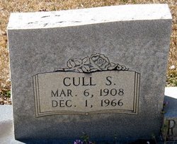
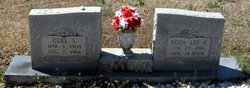
Cull Sikes Richardson
| Birth | : | 6 Mar 1908 North Carolina, USA |
| Death | : | 1 Dec 1966 Monroe, Union County, North Carolina, USA |
| Burial | : | Fairview Cemetery, Pampa, Gray County, USA |
| Coordinate | : | 35.5517006, -100.9608002 |
| Description | : | Wife was Rosa Lee Funderburk |
frequently asked questions (FAQ):
-
Where is Cull Sikes Richardson's memorial?
Cull Sikes Richardson's memorial is located at: Fairview Cemetery, Pampa, Gray County, USA.
-
When did Cull Sikes Richardson death?
Cull Sikes Richardson death on 1 Dec 1966 in Monroe, Union County, North Carolina, USA
-
Where are the coordinates of the Cull Sikes Richardson's memorial?
Latitude: 35.5517006
Longitude: -100.9608002
Family Members:
Parent

Spouse
Siblings
Flowers:


Nearby Cemetories:
1. Fairview Cemetery
Pampa, Gray County, USA
Coordinate: 35.5517006, -100.9608002
2. First Presbyterian Church Columbarium
Pampa, Gray County, USA
Coordinate: 35.5387700, -100.9686900
3. Saint Matthew's Episcopal Church Columbarium
Pampa, Gray County, USA
Coordinate: 35.5354480, -100.9697410
4. Memory Gardens of Pampa
Pampa, Gray County, USA
Coordinate: 35.5611000, -100.9916992
5. Lefors Memorial Heights Cemetery
Lefors, Gray County, USA
Coordinate: 35.4366390, -100.7953260
6. Sacred Heart Cemetery
White Deer, Carson County, USA
Coordinate: 35.4444008, -101.1763992
7. White Deer Cemetery
White Deer, Carson County, USA
Coordinate: 35.4152985, -101.1836014
8. Darsey Cemetery
Alanreed, Gray County, USA
Coordinate: 35.3597946, -100.7690887
9. Eldridge Cemetery
Gray County, USA
Coordinate: 35.2771988, -100.7722015
10. Haynes Family Cemetery
Denworth, Gray County, USA
Coordinate: 35.3929380, -100.6112110
11. Saint Marys Cemetery
Groom, Carson County, USA
Coordinate: 35.2208100, -101.1169600
12. Groom Cemetery
Groom, Carson County, USA
Coordinate: 35.1946983, -101.1327972
13. Jericho Cemetery
Jericho, Donley County, USA
Coordinate: 35.1655998, -100.9203033
14. Panhandle Cemetery
Panhandle, Carson County, USA
Coordinate: 35.3534740, -101.3701260
15. Alanreed Cemetery
Alanreed, Gray County, USA
Coordinate: 35.2114880, -100.7242870
16. Boydston Cemetery
Donley County, USA
Coordinate: 35.1516991, -100.9914017
17. Hillcrest Cemetery
McLean, Gray County, USA
Coordinate: 35.2400017, -100.6078033
18. Goodnight Cemetery
Goodnight, Armstrong County, USA
Coordinate: 35.0463982, -101.1735992
19. Claude Cemetery
Claude, Armstrong County, USA
Coordinate: 35.1324997, -101.3799973
20. Liberty Cemetery
Carson County, USA
Coordinate: 35.2806015, -101.5496979
21. Washburn Cemetery
Washburn, Armstrong County, USA
Coordinate: 35.1767006, -101.5419006
22. Odd Fellows Cemetery
Clarendon, Donley County, USA
Coordinate: 34.9188995, -100.8863983
23. Citizens Cemetery
Clarendon, Donley County, USA
Coordinate: 34.9192009, -100.8803024
24. Saint Marys Cemetery
Clarendon, Donley County, USA
Coordinate: 34.9188995, -100.8833008