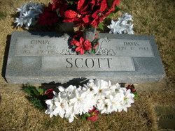
Cynthia Ruth “Cindy” McCrary Scott
| Birth | : | 4 Jun 1946 |
| Death | : | 29 Jul 1992 Neosho, Newton County, Missouri, USA |
| Burial | : | Wolf Stake Cemetery, West Union, Oconee County, USA |
| Coordinate | : | 34.8018990, -82.9785995 |
| Description | : | Cynthia Scott -- Neosho, Mo. -- Cynthia Ruth Scott, 46, Neosho route 1, died at 7:43 p.m. Wednesday at Sale Hospital, Neosho, after a long illness. Mrs. Scott was born June 4, 1946, at Brookfield. She had lived in the Neosho area since 1961, moving from California. She was a 1964 graduate of Neosho High School, and was a member of Burkhart Church of Christ. She and her husband owned and operated Scott's Boot and Tackle, Neosho. She married Davis Scott on Nov. 1, 1963, in Neosho. He survives. Additonal survivors include a son, Tim Scott, Anderson; two daughters, Stacia... Read More |
frequently asked questions (FAQ):
-
Where is Cynthia Ruth “Cindy” McCrary Scott's memorial?
Cynthia Ruth “Cindy” McCrary Scott's memorial is located at: Wolf Stake Cemetery, West Union, Oconee County, USA.
-
When did Cynthia Ruth “Cindy” McCrary Scott death?
Cynthia Ruth “Cindy” McCrary Scott death on 29 Jul 1992 in Neosho, Newton County, Missouri, USA
-
Where are the coordinates of the Cynthia Ruth “Cindy” McCrary Scott's memorial?
Latitude: 34.8018990
Longitude: -82.9785995
Family Members:
Spouse
Flowers:
Nearby Cemetories:
1. Wolf Stake Cemetery
West Union, Oconee County, USA
Coordinate: 34.8018990, -82.9785995
2. Ebenezer Baptist Church Cemetery
West Union, Oconee County, USA
Coordinate: 34.7879340, -83.0016720
3. Mountain Springs Baptist Church Cemetery
Walhalla, Oconee County, USA
Coordinate: 34.8100333, -83.0130833
4. Welcome Wesleyan Methodist Church
Seneca, Oconee County, USA
Coordinate: 34.7769140, -82.9982490
5. Old New Hope Cemetery
Oconee County, USA
Coordinate: 34.7694016, -82.9760971
6. Sanders Family
West Union, Oconee County, USA
Coordinate: 34.7849570, -83.0137770
7. Walhalla Church of God #2 Cemetery
Walhalla, Oconee County, USA
Coordinate: 34.8251320, -83.0127950
8. Ivester and Von Lehe Family Cemetery
West Union, Oconee County, USA
Coordinate: 34.7948930, -83.0234030
9. High Falls Cemetery
Oconee County, USA
Coordinate: 34.8013992, -82.9310989
10. New Hope Cemetery
Seneca, Oconee County, USA
Coordinate: 34.7667007, -82.9543991
11. Rogers Cemetery
Oconee County, USA
Coordinate: 34.8414001, -82.9933014
12. Hunnicutt Family Cemetery
Salem, Oconee County, USA
Coordinate: 34.8339350, -82.9378370
13. Bethel Presbyterian Church Cemetery
Walhalla, Oconee County, USA
Coordinate: 34.8302002, -83.0298004
14. Fairview Community Church Cemetery
Fairview, Oconee County, USA
Coordinate: 34.7492472, -82.9711269
15. Stamp Creek Cemetery
Oconee County, USA
Coordinate: 34.8417015, -82.9250031
16. Flat Shoals Baptist Cemetery
Salem, Oconee County, USA
Coordinate: 34.8591220, -83.0107420
17. Fairview Church Of God Cemetery
Seneca, Oconee County, USA
Coordinate: 34.7392140, -82.9590510
18. Ross Cemetery
Salem, Oconee County, USA
Coordinate: 34.8671989, -82.9682999
19. Pleasant Ridge Baptist Church Cemetery
Walhalla, Oconee County, USA
Coordinate: 34.8311005, -83.0511017
20. New Foundation Cemetery
Oconee County, USA
Coordinate: 34.7668991, -82.9077988
21. New Canaan Baptist Church Cemetery
Seneca, Oconee County, USA
Coordinate: 34.7391790, -82.9462700
22. Piney Grove Cemetery
West Union, Oconee County, USA
Coordinate: 34.7505989, -83.0335999
23. Mountain View Wesleyan Church Cemetery
Salem, Oconee County, USA
Coordinate: 34.8713341, -82.9733658
24. Little-Jenkins Cemetery
Oconee County, USA
Coordinate: 34.7883730, -82.8916650


