
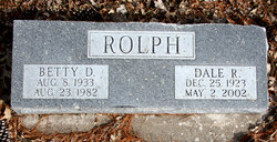
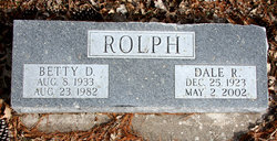
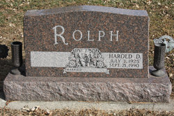
Dale R. Rolph
| Birth | : | 25 Dec 1924 Eldora, Hardin County, Iowa, USA |
| Death | : | 2 May 2002 Marshalltown, Marshall County, Iowa, USA |
| Burial | : | Pennville IOOF Cemetery, Pennville, Jay County, USA |
| Coordinate | : | 40.4943300, -85.1356600 |
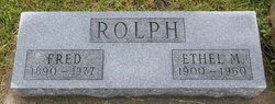
| Description | : | Son of Fred T. & Ethel M. (Stout) Rolph Veteran of World War 2 |
frequently asked questions (FAQ):
-
Where is Dale R. Rolph's memorial?
Dale R. Rolph's memorial is located at: Pennville IOOF Cemetery, Pennville, Jay County, USA.
-
When did Dale R. Rolph death?
Dale R. Rolph death on 2 May 2002 in Marshalltown, Marshall County, Iowa, USA
-
Where are the coordinates of the Dale R. Rolph's memorial?
Latitude: 40.4943300
Longitude: -85.1356600
Family Members:
Parent

Spouse
Siblings
Flowers:


Nearby Cemetories:
1. Pennville IOOF Cemetery
Pennville, Jay County, USA
Coordinate: 40.4943300, -85.1356600
2. Hillside Cemetery
Pennville, Jay County, USA
Coordinate: 40.4946300, -85.1418300
3. Maple Lawn Cemetery
Pennville, Jay County, USA
Coordinate: 40.4942017, -85.1427994
4. Gilead Cemetery
Penn Township, Jay County, USA
Coordinate: 40.5307999, -85.1427994
5. West Grove Cemetery
Penn Township, Jay County, USA
Coordinate: 40.5317001, -85.1164017
6. Winters Cemetery
Knox Township, Jay County, USA
Coordinate: 40.4392014, -85.1502991
7. Center Cemetery
Greene Township, Jay County, USA
Coordinate: 40.4460068, -85.0764313
8. Whiteman Cemetery
Greene Township, Jay County, USA
Coordinate: 40.4287700, -85.1036700
9. Whicker Cemetery
Greene Township, Jay County, USA
Coordinate: 40.4674988, -85.0344009
10. Claycomb Cemetery
Greene Township, Jay County, USA
Coordinate: 40.4118996, -85.1306000
11. Ruple-Union Cemetery
Jackson Township, Jay County, USA
Coordinate: 40.5118170, -85.0287990
12. Wells Cemetery
Jackson Township, Jay County, USA
Coordinate: 40.5116800, -85.0282640
13. Whaley Cemetery
Greene Township, Jay County, USA
Coordinate: 40.4124100, -85.0945830
14. Nottingham Cemetery
Wells County, USA
Coordinate: 40.5816650, -85.1497879
15. Brooks Family Cemetery
Knox Township, Jay County, USA
Coordinate: 40.4044440, -85.1324990
16. Trenton South Cemetery
Blackford County, USA
Coordinate: 40.4482000, -85.2386000
17. Bloxsom Cemetery
Wells County, USA
Coordinate: 40.5750008, -85.1932983
18. Trenton West Cemetery
Trenton, Blackford County, USA
Coordinate: 40.4499000, -85.2420000
19. Pleasantdale Cemetery
Blackford County, USA
Coordinate: 40.4948807, -85.2583694
20. Twibell South Cemetery
Montpelier, Blackford County, USA
Coordinate: 40.5153008, -85.2589035
21. Sager Cemetery
Greene Township, Jay County, USA
Coordinate: 40.4240330, -85.0393030
22. White Oak Cemetery
Jackson Township, Jay County, USA
Coordinate: 40.5638199, -85.0339737
23. Wayman Cemetery
Hartford City, Blackford County, USA
Coordinate: 40.4071710, -85.2162270
24. Hearn Cemetery
Wayne Township, Jay County, USA
Coordinate: 40.4386230, -85.0152160