


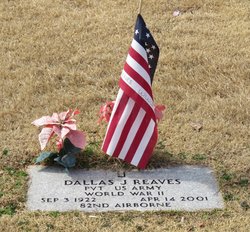
Dallas Jonah Reaves
| Birth | : | 3 Sep 1922 Johnston County, North Carolina, USA |
| Death | : | 14 Apr 2001 Durham, Durham County, North Carolina, USA |
| Burial | : | Calvary Cemetery, Cleveland, Cuyahoga County, USA |
| Coordinate | : | 41.4449900, -81.6147300 |
| Plot | : | # 198 Mount Herman Babtist Church Cemetery |
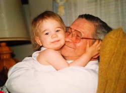
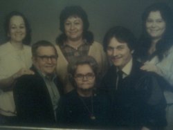
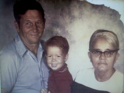
| Description | : | Son of Jonah Ransom Reaves and Lessie Mae Jones Reaves. Brother of: William M Reaves(1910-1958) Joseph Marshall Reaves Emily Arnette Reaves Bagley Robert Lee Reaves(1915-1991) James Edward Reaves Charlie Thornton Reaves Jesse David Reaves(1919-1994) Mary Reaves Cook(1921-1998) [Dallas Jonah Reaves] Otha H Reaves Annie Mae Reaves Monds Jonas Ransom Reaves Jr(1927-1992) Roy Lee Reaves(1938-1996) Married to Ruth Bass. Dallas and Ruth were the parents of: Shirley Ann Reaves(unk-unk) Sara Lee Reaves(unk-unk) Elizabeth Marie Reaves(unk-unk) Dallas Douglas Reaves Jr(unk-unk) ********************************* US Army ( PFC ) 82nd Airborne Fort Bragg NC. .. Anti Coast Artillery ( Omaha Beach ) Germany.... 1943.. Born : Sept 3. 1922.. Died : April 14. 2001.. Husband of Ruth ( Bass ) Reaves... Read More |
frequently asked questions (FAQ):
-
Where is Dallas Jonah Reaves's memorial?
Dallas Jonah Reaves's memorial is located at: Calvary Cemetery, Cleveland, Cuyahoga County, USA.
-
When did Dallas Jonah Reaves death?
Dallas Jonah Reaves death on 14 Apr 2001 in Durham, Durham County, North Carolina, USA
-
Where are the coordinates of the Dallas Jonah Reaves's memorial?
Latitude: 41.4449900
Longitude: -81.6147300
Family Members:

Flowers:


Nearby Cemetories:
1. Calvary Cemetery
Cleveland, Cuyahoga County, USA
Coordinate: 41.4449900, -81.6147300
2. Cleveland State Hospital Cemetery
Newburgh Heights, Cuyahoga County, USA
Coordinate: 41.4393010, -81.6177790
3. Harvard Grove Cemetery
Cleveland, Cuyahoga County, USA
Coordinate: 41.4522040, -81.6471880
4. Harvard Cemetery
Cleveland, Cuyahoga County, USA
Coordinate: 41.4485321, -81.6483917
5. Baxter Cemetery
Cleveland, Cuyahoga County, USA
Coordinate: 41.4596596, -81.6432800
6. Saint Marys Cemetery
Cuyahoga Heights, Cuyahoga County, USA
Coordinate: 41.4296989, -81.6427994
7. Lansing Cemetery
Cleveland, Cuyahoga County, USA
Coordinate: 41.4502983, -81.6492004
8. Saint John Lutheran Cemetery
Garfield Heights, Cuyahoga County, USA
Coordinate: 41.4164009, -81.6046982
9. Warrensville West Cemetery
Shaker Heights, Cuyahoga County, USA
Coordinate: 41.4655991, -81.5655975
10. Saint Josephs Cemetery
Cleveland, Cuyahoga County, USA
Coordinate: 41.4869003, -81.6318970
11. Saint John Cemetery
Cleveland, Cuyahoga County, USA
Coordinate: 41.4860992, -81.6408005
12. Foote Family Cemetery
Brooklyn Heights, Cuyahoga County, USA
Coordinate: 41.4199830, -81.6717380
13. Woodland Cemetery
Cleveland, Cuyahoga County, USA
Coordinate: 41.4900017, -81.6425018
14. Harper-MacArthur Cemetery
Independence, Cuyahoga County, USA
Coordinate: 41.3947450, -81.6249160
15. Zion Lutheran Cemetery
Maple Heights, Cuyahoga County, USA
Coordinate: 41.4033012, -81.5757980
16. Maple Shade Cemetery
Independence, Cuyahoga County, USA
Coordinate: 41.3955994, -81.6393967
17. West Family Cemetery
Independence, Cuyahoga County, USA
Coordinate: 41.3993301, -81.6499939
18. Shaker Burial Ground
Shaker Heights, Cuyahoga County, USA
Coordinate: 41.4827766, -81.5628128
19. Fairmount Presbyterian Church Columbarium
Cleveland Heights, Cuyahoga County, USA
Coordinate: 41.4932930, -81.5801210
20. Saint Lawrence Cemetery
Independence, Cuyahoga County, USA
Coordinate: 41.3989601, -81.6584625
21. Saint Pauls Episcopal Church Columbarium
Cleveland Heights, Cuyahoga County, USA
Coordinate: 41.4956350, -81.5812450
22. Crossview Cemetery
Seven Hills, Cuyahoga County, USA
Coordinate: 41.4022789, -81.6688995
23. Epworth Euclid United Methodist Church Columbarium
Euclid, Cuyahoga County, USA
Coordinate: 41.5058200, -81.6124990
24. Christ Episcopal Church Columbarium
Shaker Heights, Cuyahoga County, USA
Coordinate: 41.4658356, -81.5362854