

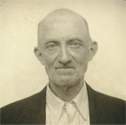
Dalton Oliver McLaughlin
| Birth | : | 28 Dec 1915 Ava, Noble County, Ohio, USA |
| Death | : | 28 Oct 1999 Columbus, Franklin County, Ohio, USA |
| Burial | : | Heywood Cemetery, Heywood, Metropolitan Borough of Rochdale, England |
| Coordinate | : | 53.6010610, -2.1931250 |
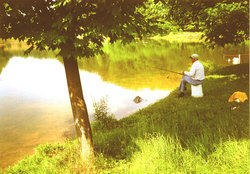
| Description | : | Dalton was the second of four children born to Willison and Mary (Wagner) McLaughlin. He was born in Ava, OH. Ava is a small town located in Northwestern Noble County. In the early 1900's, Ava and the general area was booming with coal mines that dotted the country side. It seems, from stories I have heard, that almost every other farm had a coal mine located on it. This part of Ohio is quite hilly and there are many caves scattered throughout the area. At maturity, Dalton stood 5'6 1/2" tall, weighed 135-140 pounds. He had blue eyes and brown... Read More |
frequently asked questions (FAQ):
-
Where is Dalton Oliver McLaughlin's memorial?
Dalton Oliver McLaughlin's memorial is located at: Heywood Cemetery, Heywood, Metropolitan Borough of Rochdale, England.
-
When did Dalton Oliver McLaughlin death?
Dalton Oliver McLaughlin death on 28 Oct 1999 in Columbus, Franklin County, Ohio, USA
-
Where are the coordinates of the Dalton Oliver McLaughlin's memorial?
Latitude: 53.6010610
Longitude: -2.1931250
Family Members:
Parent
Spouse
Siblings

Children

Flowers:


Nearby Cemetories:
1. Heywood Cemetery
Heywood, Metropolitan Borough of Rochdale, England
Coordinate: 53.6010610, -2.1931250
2. Rochdale Cemetery
Rochdale, Metropolitan Borough of Rochdale, England
Coordinate: 53.6132698, -2.1833401
3. Rochdale Crematorium
Rochdale, Metropolitan Borough of Rochdale, England
Coordinate: 53.6160820, -2.1830570
4. St Martin Churchyard
Castleton Moor, Metropolitan Borough of Rochdale, England
Coordinate: 53.5885050, -2.1756140
5. Denehurst Cemetery
Rochdale, Metropolitan Borough of Rochdale, England
Coordinate: 53.6206199, -2.1821104
6. St. John's Churchyard Thornham
Middleton, Metropolitan Borough of Rochdale, England
Coordinate: 53.5760100, -2.1718300
7. St. James Ashworth
Rochdale, Metropolitan Borough of Rochdale, England
Coordinate: 53.6214693, -2.2261040
8. St. Paul's Churchyard
Norden, Metropolitan Borough of Rochdale, England
Coordinate: 53.6273006, -2.2126936
9. Christ Church Churchyard
Healey, Metropolitan Borough of Rochdale, England
Coordinate: 53.6378630, -2.1741198
10. St. Mary's Churchyard Birch-In-Hopwood
Heywood, Metropolitan Borough of Rochdale, England
Coordinate: 53.5662410, -2.2247560
11. Boarshaw Cemetery and Crematorium
Middleton, Metropolitan Borough of Rochdale, England
Coordinate: 53.5584100, -2.1773100
12. Middleton Cemetery and Crematorium
Middleton, Metropolitan Borough of Rochdale, England
Coordinate: 53.5574400, -2.1829200
13. Royton Cemetery
Royton, Metropolitan Borough of Oldham, England
Coordinate: 53.5727450, -2.1302850
14. Old Burial Grounds
Middleton, Metropolitan Borough of Rochdale, England
Coordinate: 53.5534036, -2.1948053
15. St Leonard's Churchyard
Middleton, Metropolitan Borough of Rochdale, England
Coordinate: 53.5530640, -2.1945060
16. St Matthew Churchyard
Chadderton, Metropolitan Borough of Oldham, England
Coordinate: 53.5565975, -2.1528452
17. St. Michael's Churchyard
Middleton, Metropolitan Borough of Rochdale, England
Coordinate: 53.5476600, -2.1907240
18. Saint Paul Churchyard
Royton, Metropolitan Borough of Oldham, England
Coordinate: 53.5653330, -2.1261450
19. St Bartholomew Churchyard
Whitworth, Rossendale Borough, England
Coordinate: 53.6553000, -2.1709700
20. St. Gabriel's Churchyard
Middleton, Metropolitan Borough of Rochdale, England
Coordinate: 53.5446736, -2.1742074
21. St. Thomas Churchyard
Newhey, Metropolitan Borough of Rochdale, England
Coordinate: 53.6019166, -2.0958889
22. St John's Churchyard
Bury, Metropolitan Borough of Bury, England
Coordinate: 53.5954900, -2.2910100
23. Crompton Cemetery
Shaw, Metropolitan Borough of Oldham, England
Coordinate: 53.5799840, -2.1003410
24. St Georges Churchyard
Unsworth, Metropolitan Borough of Bury, England
Coordinate: 53.5668741, -2.2745340