
| Birth | : | 2 Oct 1872 Carroll, Coos County, New Hampshire, USA |
| Death | : | 3 Oct 1947 Lancaster, Coos County, New Hampshire, USA |
| Burial | : | Straw Cemetery, Carroll, Coos County, USA |
| Coordinate | : | 44.3101300, -71.5507000 |
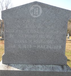
| Description | : | Dana was the son of Mark P. Rosebrook and Sallie H. Howe. On Oct 28, 1913 in Medford, MA he married Bertha May Darling, daughter of Willard Darling and Ella A. Brown. Per his birth certificate he was born October 2, 1871 Per U.S., Social Security Applications and Claims Index, 1936-2007 his date of birth was October 1, 1872. Per New Hampshire, Death and Disinterment Records, 1754-1947..his date of death was October 3, 1947. |
frequently asked questions (FAQ):
-
Where is Dana Mark Rosebrook's memorial?
Dana Mark Rosebrook's memorial is located at: Straw Cemetery, Carroll, Coos County, USA.
-
When did Dana Mark Rosebrook death?
Dana Mark Rosebrook death on 3 Oct 1947 in Lancaster, Coos County, New Hampshire, USA
-
Where are the coordinates of the Dana Mark Rosebrook's memorial?
Latitude: 44.3101300
Longitude: -71.5507000
Family Members:
Flowers:


Nearby Cemetories:
1. Straw Cemetery
Carroll, Coos County, USA
Coordinate: 44.3101300, -71.5507000
2. Rosebrook Cemetery
Carroll, Coos County, USA
Coordinate: 44.2739400, -71.5709600
3. Saint Margaret Cemetery
Twin Mountain, Coos County, USA
Coordinate: 44.2681160, -71.5428391
4. Kimball Hill Cemetery
Whitefield, Coos County, USA
Coordinate: 44.3569660, -71.6229410
5. Park Street Cemetery
Whitefield, Coos County, USA
Coordinate: 44.3737100, -71.6022000
6. Applebee Family Cemetery
Jefferson, Coos County, USA
Coordinate: 44.3508300, -71.4633400
7. Burns Cemetery
Whitefield, Coos County, USA
Coordinate: 44.3577200, -71.6312200
8. Old Cemetery
Whitefield, Coos County, USA
Coordinate: 44.3743190, -71.6106680
9. Pine Street Cemetery
Whitefield, Coos County, USA
Coordinate: 44.3792000, -71.6175200
10. Saint Matthews Cemetery
Whitefield, Coos County, USA
Coordinate: 44.3820400, -71.6163300
11. Crawford Cemetery
Carroll, Coos County, USA
Coordinate: 44.2607680, -71.4514630
12. Forest Vale Cemetery
Jefferson, Coos County, USA
Coordinate: 44.3804800, -71.4754700
13. Colby Cemetery
Whitefield, Coos County, USA
Coordinate: 44.4018400, -71.5498100
14. Maple Street Cemetery
Bethlehem, Grafton County, USA
Coordinate: 44.2858370, -71.6846050
15. Ladd Cemetery
Dalton, Coos County, USA
Coordinate: 44.3790440, -71.6550400
16. Bethlehem Cemetery
Bethlehem, Grafton County, USA
Coordinate: 44.2803870, -71.6945420
17. Mount Washington Cemetery
Bethlehem, Grafton County, USA
Coordinate: 44.2797620, -71.6944050
18. Starr King Cemetery
Jefferson, Coos County, USA
Coordinate: 44.4014800, -71.4424400
19. Hillside Cemetery
Jefferson, Coos County, USA
Coordinate: 44.4169000, -71.4746400
20. Black Velvet Cemetery
Jefferson, Coos County, USA
Coordinate: 44.3741670, -71.4086110
21. Riverton Cemetery
Jefferson, Coos County, USA
Coordinate: 44.4336200, -71.5309300
22. Number 10 Cemetery
Lancaster, Coos County, USA
Coordinate: 44.4246900, -71.6270600
23. Wilkins Cemetery
Littleton, Grafton County, USA
Coordinate: 44.3343430, -71.7301600
24. Kilkenny View Cemetery
Jefferson, Coos County, USA
Coordinate: 44.4384080, -71.5146010