
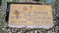
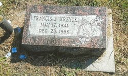
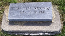
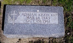
Daniel H. Krzycki
| Birth | : | 3 Nov 1930 Silver Creek, Merrick County, Nebraska, USA |
| Death | : | 10 Apr 1972 Columbus, Platte County, Nebraska, USA |
| Burial | : | Glenwood Cemetery, East Greenwich, Kent County, USA |
| Coordinate | : | 41.6550900, -71.4645200 |
| Description | : | http://www.rootsweb.ancestry.com/~neplatte/vitals/vitals1972.html The Columbus Telegram, April 10, 1972 KRZYCKI--Daniel Krzycki Daniel H. Krzycki, 44, of 754 24th Avenue, died this morning at Behlen Memorial Hospital. He had been in poor health the past year. Fr. Armand Lubanski will officiate at funeral rites, 10 a.m. Wednesday at St. Anthony Church. Burial will be in St. Bonaventure Cemetery. The body is to lie in state after 1 p.m. Tuesday at McKown Funeral Home, where rosary will be prayed at 7 p.m. Tuesday by the Knights of Columbus, 7:30 by the Holy Name Society, and 8 o'clock... Read More |
frequently asked questions (FAQ):
-
Where is Daniel H. Krzycki's memorial?
Daniel H. Krzycki's memorial is located at: Glenwood Cemetery, East Greenwich, Kent County, USA.
-
When did Daniel H. Krzycki death?
Daniel H. Krzycki death on 10 Apr 1972 in Columbus, Platte County, Nebraska, USA
-
Where are the coordinates of the Daniel H. Krzycki's memorial?
Latitude: 41.6550900
Longitude: -71.4645200
Family Members:
Parent
Spouse

Siblings
Flowers:


Nearby Cemetories:
1. Glenwood Cemetery
East Greenwich, Kent County, USA
Coordinate: 41.6550900, -71.4645200
2. Daniel Howland Lot
East Greenwich, Kent County, USA
Coordinate: 41.6564331, -71.4653168
3. Captain Samuel Fry Lot
East Greenwich, Kent County, USA
Coordinate: 41.6567039, -71.4653168
4. Payne-Spencer Lot
East Greenwich, Kent County, USA
Coordinate: 41.6566772, -71.4657288
5. Saint Patrick Cemetery
East Greenwich, Kent County, USA
Coordinate: 41.6522179, -71.4576416
6. East Greenwich Cemetery
East Greenwich, Kent County, USA
Coordinate: 41.6553345, -71.4551392
7. Nichols Lot
East Greenwich, Kent County, USA
Coordinate: 41.6505810, -71.4751300
8. Clement Weaver Lot
East Greenwich, Kent County, USA
Coordinate: 41.6620800, -71.4743700
9. Gertrude Parker Stone
East Greenwich, Kent County, USA
Coordinate: 41.6593490, -71.4521600
10. Quaker Lot
East Greenwich, Kent County, USA
Coordinate: 41.6602500, -71.4524600
11. Henry Spencer Lot
East Greenwich, Kent County, USA
Coordinate: 41.6471980, -71.4743470
12. Saint Lukes Episcopal Churchyard
East Greenwich, Kent County, USA
Coordinate: 41.6614456, -71.4518433
13. Governor Greene Cemetery
Warwick, Kent County, USA
Coordinate: 41.6661000, -71.4594300
14. Captain Joseph Spencer Lot
Warwick, Kent County, USA
Coordinate: 41.6456108, -71.4551392
15. Doctor Peter Turner Lot (Defunct)
East Greenwich, Kent County, USA
Coordinate: 41.6628700, -71.4525360
16. Peirce-Spencer Lot
East Greenwich, Kent County, USA
Coordinate: 41.6422500, -71.4683610
17. Spencer Lot
East Greenwich, Kent County, USA
Coordinate: 41.6460533, -71.4808731
18. Baptist Burial Ground
East Greenwich, Kent County, USA
Coordinate: 41.6631241, -71.4467926
19. East Greenwich Swedish Cemetery
East Greenwich, Kent County, USA
Coordinate: 41.6628900, -71.4826600
20. Lutheran Church Cemetery
East Greenwich, Kent County, USA
Coordinate: 41.6628680, -71.4828150
21. Oliver Wickes Lot
East Greenwich, Kent County, USA
Coordinate: 41.6629524, -71.4834213
22. Anthony Hall Lot
East Greenwich, Kent County, USA
Coordinate: 41.6622500, -71.4839280
23. Major General Thomas Holden Lot
Warwick, Kent County, USA
Coordinate: 41.6636300, -71.4850800
24. Major Pardon Potter Lot
Warwick, Kent County, USA
Coordinate: 41.6728610, -71.4705830