

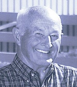


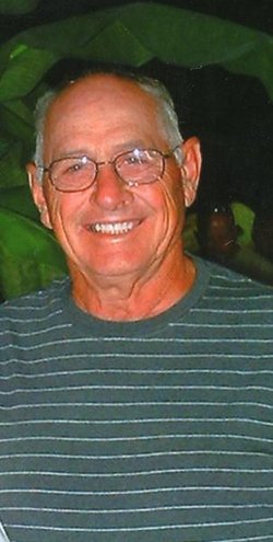
Danny E. Gettinger
| Birth | : | 1 Jul 1932 Fayette County, Indiana, USA |
| Death | : | 16 Oct 2008 Indianapolis, Marion County, Indiana, USA |
| Burial | : | Fort Dodge Memorial Park, Fort Dodge, Webster County, USA |
| Coordinate | : | 42.5032997, -94.1472015 |
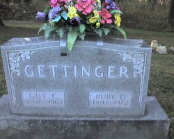
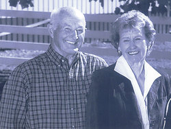
| Description | : | He was the son of Guy and Ruby (Strong) Gettinger, both deceased. He married Barbara Hamilton Jan. 15, 1956; she survives. Mr. Gettinger was a Rush County farmer. He had lived in Rush County since 1957 and prior to that in Fayette County. He was a 1950 graduate of Alquina High School. A U.S. Army veteran, he served in the Korean War. He had been a member of Little Flatrock Christian Church for more than 50 years and had served as a church trustee, deacon and Sunday School superintendent. He was a longtime member of the American Chianina Association, served as... Read More |
frequently asked questions (FAQ):
-
Where is Danny E. Gettinger's memorial?
Danny E. Gettinger's memorial is located at: Fort Dodge Memorial Park, Fort Dodge, Webster County, USA.
-
When did Danny E. Gettinger death?
Danny E. Gettinger death on 16 Oct 2008 in Indianapolis, Marion County, Indiana, USA
-
Where are the coordinates of the Danny E. Gettinger's memorial?
Latitude: 42.5032997
Longitude: -94.1472015
Family Members:
Parent

Spouse
Siblings


Nearby Cemetories:
1. Oakland Cemetery
Fort Dodge, Webster County, USA
Coordinate: 42.5214005, -94.1800003
2. Corpus Christi Cemetery
Fort Dodge, Webster County, USA
Coordinate: 42.5243988, -94.1802979
3. North Lawn Cemetery
Fort Dodge, Webster County, USA
Coordinate: 42.5290000, -94.1778000
4. Saint Olafs Cemetery
Fort Dodge, Webster County, USA
Coordinate: 42.5017014, -94.2153015
5. Carpenter Cemetery
Webster County, USA
Coordinate: 42.5015907, -94.2166061
6. Concordia Cemetery
Fort Dodge, Webster County, USA
Coordinate: 42.5628014, -94.1949997
7. Webster County Home Cemetery
Fort Dodge, Webster County, USA
Coordinate: 42.4563710, -94.2181420
8. Holaday Creek Cemetery
Webster County, USA
Coordinate: 42.4472008, -94.0886002
9. Willowledge Cemetery
Fort Dodge, Webster County, USA
Coordinate: 42.5250015, -94.2388916
10. Graceland Cemetery
Elkhorn Township, Webster County, USA
Coordinate: 42.4275017, -94.2127991
11. Colfax Cemetery
Webster County, USA
Coordinate: 42.5224991, -94.0194016
12. Burns Cemetery
Webster County, USA
Coordinate: 42.5249970, -94.2759880
13. Elkhorn Cemetery
Webster County, USA
Coordinate: 42.4277992, -94.2328033
14. Elkhorn Township Cemetery
Fort Dodge, Webster County, USA
Coordinate: 42.4276120, -94.2329690
15. Otho Cemetery
Otho, Webster County, USA
Coordinate: 42.4025002, -94.1153030
16. Washington Township Cemetery
Duncombe, Webster County, USA
Coordinate: 42.4707900, -94.0002000
17. Saint Josephs Cemetery
Duncombe, Webster County, USA
Coordinate: 42.4789009, -93.9922028
18. Trinity Lutheran Cemetery
Webster County, USA
Coordinate: 42.5875015, -94.2581024
19. Old Lizard Cemetery
Webster County, USA
Coordinate: 42.5249720, -94.3141340
20. Newark Township Cemetery
Vincent, Webster County, USA
Coordinate: 42.6021996, -94.0408020
21. Hovey Cemetery
Badger, Webster County, USA
Coordinate: 42.6290000, -94.1730000
22. Pioneer Cemetery
Badger, Webster County, USA
Coordinate: 42.6306000, -94.1477966
23. Blossom Hill Cemetery
Badger, Webster County, USA
Coordinate: 42.6286011, -94.1100006
24. Our Lady of Good Counsel Cemetery
Moorland, Webster County, USA
Coordinate: 42.4427986, -94.3043976