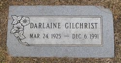
Darlaine Myrtus Heinz Gilchrist
| Birth | : | 24 Mar 1925 Day County, South Dakota, USA |
| Death | : | 6 Dec 1991 Great Falls, Cascade County, Montana, USA |
| Burial | : | Brush Creek Cemetery, Casey County, USA |
| Coordinate | : | 37.3450220, -84.9564950 |
| Plot | : | Section 3-A |
| Description | : | Born Darlaine Myrtus Heinz on March 24, 1925, to Harry W Heinz (1897, 1994) and Ethel Olivia Swanson (1901, ?), in Day County, South Dakota, USA. Darlaine continued to reside in Day county, at Homer, then at Farmington, throughout her childhood. On, or around, April 1, 1940, her family moved to Riverside, Brown county, South Dakota, when Darlaine was 15 years of age. At 21, (e.g. 1946), Darlaine married Charles Kenneth (Chuck) Gilchrist (1925, 2004) of South Dakota. Charles Gilchrist had recently discharged from the US Navy, and the couples near in time wedding leaves open the possibility that Charles and... Read More |
frequently asked questions (FAQ):
-
Where is Darlaine Myrtus Heinz Gilchrist's memorial?
Darlaine Myrtus Heinz Gilchrist's memorial is located at: Brush Creek Cemetery, Casey County, USA.
-
When did Darlaine Myrtus Heinz Gilchrist death?
Darlaine Myrtus Heinz Gilchrist death on 6 Dec 1991 in Great Falls, Cascade County, Montana, USA
-
Where are the coordinates of the Darlaine Myrtus Heinz Gilchrist's memorial?
Latitude: 37.3450220
Longitude: -84.9564950
Family Members:
Spouse
Flowers:
Nearby Cemetories:
1. Brush Creek Cemetery
Casey County, USA
Coordinate: 37.3450220, -84.9564950
2. Atwood Cemetery
Casey County, USA
Coordinate: 37.3614000, -84.9797000
3. Grace Baptist Church Cemetery
Casey County, USA
Coordinate: 37.3608000, -84.9817000
4. Liberty Colored Cemetery
Liberty, Casey County, USA
Coordinate: 37.3230553, -84.9386139
5. Bowman Cemetery
Liberty, Casey County, USA
Coordinate: 37.3217800, -84.9393300
6. Bruce's Chapel United Methodist Church Cemetery
Liberty, Casey County, USA
Coordinate: 37.3183289, -84.9394379
7. Labascus Church of Christ Cemetery
Liberty, Casey County, USA
Coordinate: 37.3183289, -84.9394379
8. Clearview Baptist Church Cemetery
Liberty, Casey County, USA
Coordinate: 37.3495178, -84.9180069
9. Napier Cemetery
Liberty, Casey County, USA
Coordinate: 37.3158100, -84.9397400
10. Glenwood Cemetery
Liberty, Casey County, USA
Coordinate: 37.3258018, -84.9194031
11. Poplar Grove Cemetery
Liberty, Casey County, USA
Coordinate: 37.3717384, -84.9274521
12. Caney Fork Cemetery
Liberty, Casey County, USA
Coordinate: 37.3572640, -84.9983640
13. Wilson Cemetery
Liberty, Casey County, USA
Coordinate: 37.3758011, -84.9796982
14. Tate-Barger Cemetery
Liberty, Casey County, USA
Coordinate: 37.3409910, -84.9099400
15. Holt Family Cemetery
Beech Bottom, Casey County, USA
Coordinate: 37.3723400, -84.9240590
16. Whited Cemetery
Liberty, Casey County, USA
Coordinate: 37.3344002, -85.0072021
17. Casey County Memorial Gardens
Liberty, Casey County, USA
Coordinate: 37.3328520, -84.9060130
18. Cochran Cemetery
Beech Bottom, Casey County, USA
Coordinate: 37.3756140, -84.9191670
19. Carr Family Cemetery
Casey County, USA
Coordinate: 37.3806000, -84.9916992
20. Sweeney Cemetery
Liberty, Casey County, USA
Coordinate: 37.3393500, -85.0196621
21. Hilltop Full Gospel Church Cemetery
Casey County, USA
Coordinate: 37.3008347, -84.9091644
22. Lanhamtown Cemetery
Lanhamtown, Casey County, USA
Coordinate: 37.3398110, -84.8799270
23. Scotts Chapel Cemetery
Atterson, Casey County, USA
Coordinate: 37.3643417, -85.0343704
24. White Oak Church Cemetery
Clementsville, Casey County, USA
Coordinate: 37.3409042, -85.0396805


