

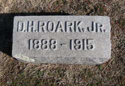
David Harlan “D.H.” Roark Jr.
| Birth | : | 6 Aug 1888 Harper, Harper County, Kansas, USA |
| Death | : | 12 Apr 1915 Wind River, Fremont County, Wyoming, USA |
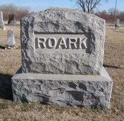
| Burial | : | Campbell Cemetery, Claiborne County, USA |
| Coordinate | : | 36.3680992, -83.6406021 |
| Description | : | Harper Advocate Harper, Kansas Thursday, April 22, 1915 page 1 Obituary. D.H. Roark born in Harper, Kansas August 6, 1888 and died at Wind River, Wyoming April 12, 1915 after an illness lasting seven years. Most of which time was spent in traveling in a vain pursuit of health. He leaves to mourn his loss a mother, six brothers and two sisters. All were present at the funeral except one brother in Wyoming. Relatives present at the funeral were: Mrs. M.E. Roark, Mr. and Mrs. Jas. H. Roark, Mrs. W.H. Brockway, Mr. and... Read More |
frequently asked questions (FAQ):
-
Where is David Harlan “D.H.” Roark Jr.'s memorial?
David Harlan “D.H.” Roark Jr.'s memorial is located at: Campbell Cemetery, Claiborne County, USA.
-
When did David Harlan “D.H.” Roark Jr. death?
David Harlan “D.H.” Roark Jr. death on 12 Apr 1915 in Wind River, Fremont County, Wyoming, USA
-
Where are the coordinates of the David Harlan “D.H.” Roark Jr.'s memorial?
Latitude: 36.3680992
Longitude: -83.6406021
Family Members:
Parent

Siblings

Flowers:


Nearby Cemetories:
1. Campbell Cemetery
Claiborne County, USA
Coordinate: 36.3680992, -83.6406021
2. Brown Cemetery
Claiborne County, USA
Coordinate: 36.3614006, -83.6530991
3. Atkins Cemetery
Claiborne County, USA
Coordinate: 36.3814011, -83.6168976
4. Burch Cemetery
Claiborne County, USA
Coordinate: 36.3849983, -83.6699982
5. Cardwell Cemetery
Claiborne County, USA
Coordinate: 36.3911018, -83.6006012
6. Carr Cemetery
Claiborne County, USA
Coordinate: 36.3969002, -83.6810989
7. Butcher Cemetery
Union County, USA
Coordinate: 36.3511009, -83.6967010
8. Liberty Hill Cemetery
Liberty Hill, Grainger County, USA
Coordinate: 36.3171997, -83.6205978
9. Cardwell Cemetery
Claiborne County, USA
Coordinate: 36.4019012, -83.5789032
10. Frye Cemetery
Grainger County, USA
Coordinate: 36.3432610, -83.5725660
11. Hammock Cemetery
Grainger County, USA
Coordinate: 36.3097000, -83.6641998
12. Hopson Cemetery
Grainger County, USA
Coordinate: 36.3044014, -83.6157990
13. Coffey Cemetery
Claiborne County, USA
Coordinate: 36.4099998, -83.5753021
14. Days Cemetery
Claiborne County, USA
Coordinate: 36.3843994, -83.5594025
15. Johnson Cemetery
Grainger County, USA
Coordinate: 36.3130989, -83.5916977
16. Carr Cemetery
Claiborne County, USA
Coordinate: 36.3936900, -83.7184200
17. Barton Cemetery
Claiborne County, USA
Coordinate: 36.4110985, -83.5746994
18. Clapp Cemetery
Grainger County, USA
Coordinate: 36.3208008, -83.5772018
19. Boruff Cemetery
Union County, USA
Coordinate: 36.3100014, -83.6908035
20. Hopson Cemetery
Grainger County, USA
Coordinate: 36.3535995, -83.5460968
21. I. C. Hurst Cemetery
Union County, USA
Coordinate: 36.3086014, -83.7024994
22. Edwards Cemetery
Claiborne County, USA
Coordinate: 36.3857994, -83.7347031
23. Beason Cemetery
Claiborne County, USA
Coordinate: 36.3739014, -83.7375031
24. Freedom Missionary Baptist Church Cemetery
Claiborne County, USA
Coordinate: 36.4450310, -83.6214950