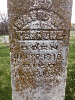
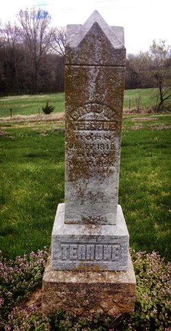
David Williamson Terhune
| Birth | : | 27 Jan 1840 Indiana, USA |
| Death | : | 17 May 1896 Reserve, Brown County, Kansas, USA |
| Burial | : | Forest City Cemetery, South Portland, Cumberland County, USA |
| Coordinate | : | 43.6333008, -70.2799988 |
| Description | : | May 15 to May 28, 1896 there were a series of tornado's that caused destruction through-out the midwest. On Sunday May 17 a tornado passed through a number of counties including Brown county. It killed a number of people including Mr. Terhune, injured many more & did damage to the towns of Frankfort, Seneca, Oneida, Sabetha and Reserve, as well as many farms along the way. "On Sunday evening while Soldier people were looking at the clouds work and viewing the electric display, a most dreadful storm was raging across the counties of Washington, Nemaha and Brown, passing off into Nebraska.... Read More |
frequently asked questions (FAQ):
-
Where is David Williamson Terhune's memorial?
David Williamson Terhune's memorial is located at: Forest City Cemetery, South Portland, Cumberland County, USA.
-
When did David Williamson Terhune death?
David Williamson Terhune death on 17 May 1896 in Reserve, Brown County, Kansas, USA
-
Where are the coordinates of the David Williamson Terhune's memorial?
Latitude: 43.6333008
Longitude: -70.2799988
Family Members:
Parent
Spouse
Siblings
Children
Flowers:
Nearby Cemetories:
1. Forest City Cemetery
South Portland, Cumberland County, USA
Coordinate: 43.6333008, -70.2799988
2. Brown's Hill Cemetery
South Portland, Cumberland County, USA
Coordinate: 43.6292114, -70.2839584
3. Calvary Cemetery
South Portland, Cumberland County, USA
Coordinate: 43.6323100, -70.2902700
4. Western Cemetery
Portland, Cumberland County, USA
Coordinate: 43.6450005, -70.2746964
5. Highland Memorial Gardens
South Portland, Cumberland County, USA
Coordinate: 43.6166992, -70.2799988
6. Memorial Garden at Cathedral Church of Saint Luke
Portland, Cumberland County, USA
Coordinate: 43.6523222, -70.2648576
7. Micah Dyer Plot
South Portland, Cumberland County, USA
Coordinate: 43.6196650, -70.2554380
8. Wescott Cemetery
South Portland, Cumberland County, USA
Coordinate: 43.6244389, -70.3093639
9. Bay View Cemetery
South Portland Gardens, Cumberland County, USA
Coordinate: 43.6259960, -70.2477840
10. Long Creek Cemetery
South Portland, Cumberland County, USA
Coordinate: 43.6328166, -70.3181143
11. Mount Pleasant Cemetery
South Portland, Cumberland County, USA
Coordinate: 43.6356010, -70.2403030
12. First Parish Church
Portland, Cumberland County, USA
Coordinate: 43.6583142, -70.2580524
13. Meeting House Hill
South Portland, Cumberland County, USA
Coordinate: 43.6354030, -70.2391200
14. Brooklawn Memorial Park
Portland, Cumberland County, USA
Coordinate: 43.6501274, -70.3214493
15. Stroudwater Burying Ground
Portland, Cumberland County, USA
Coordinate: 43.6582000, -70.3147100
16. Smith Street Cemetery
South Portland, Cumberland County, USA
Coordinate: 43.6414940, -70.2314440
17. Eastern Cemetery
Portland, Cumberland County, USA
Coordinate: 43.6624985, -70.2506027
18. Temple Beth El Memorial Park
Portland, Cumberland County, USA
Coordinate: 43.6503060, -70.3243020
19. Old Settlers Cemetery
South Portland, Cumberland County, USA
Coordinate: 43.6457110, -70.2274690
20. 1812 Memorial
Portland, Cumberland County, USA
Coordinate: 43.6704930, -70.2466300
21. Skillin Cemetery
South Portland, Cumberland County, USA
Coordinate: 43.6363000, -70.3451100
22. Evergreen Cemetery
Portland, Cumberland County, USA
Coordinate: 43.6800003, -70.3016968
23. Fort Scammel
Portland, Cumberland County, USA
Coordinate: 43.6492500, -70.2132800
24. Pine Grove Cemetery
Portland, Cumberland County, USA
Coordinate: 43.6836014, -70.2985992


