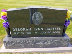
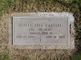
Deborah Lynn Baker Casteel
| Birth | : | 21 May 1953 Maryville, Nodaway County, Missouri, USA |
| Death | : | 20 Jul 2008 Cameron, Clinton County, Missouri, USA |
| Burial | : | Calvary Cemetery, Yakima, Yakima County, USA |
| Coordinate | : | 46.5790740, -120.5407420 |
| Description | : | Deborah Lynn Casteel, 55, Maryville, Missouri, formerly of Maryville, Missouri, died Sunday, July 20, 2008, at Cameron Regional Medical Center in Cameron, Missouri. She was born May 21, 1953, in Maryville, to Richard and Shirley Murphy Baker. She was a 1971 graduate of Maryville High School. Deborah was a former employee of Union Carbide Corporation and was a member of Laura Street Baptist Church, both in Maryville. She was preceded in death by her parents. She is survived by two sons; Travis Casteel and wife Cortney, Marysville, and Casey Casteel and wife Amanda, Cromwell, Indiana; two... Read More |
frequently asked questions (FAQ):
-
Where is Deborah Lynn Baker Casteel's memorial?
Deborah Lynn Baker Casteel's memorial is located at: Calvary Cemetery, Yakima, Yakima County, USA.
-
When did Deborah Lynn Baker Casteel death?
Deborah Lynn Baker Casteel death on 20 Jul 2008 in Cameron, Clinton County, Missouri, USA
-
Where are the coordinates of the Deborah Lynn Baker Casteel's memorial?
Latitude: 46.5790740
Longitude: -120.5407420
Family Members:
Parent
Spouse
Flowers:
Nearby Cemetories:
1. Calvary Cemetery
Yakima, Yakima County, USA
Coordinate: 46.5790740, -120.5407420
2. Tahoma Cemetery
Yakima, Yakima County, USA
Coordinate: 46.5753610, -120.5332320
3. Yemowat Cemetery
Yakima County, USA
Coordinate: 46.5475006, -120.5730972
4. Lewis Family Cemetery
Yakima, Yakima County, USA
Coordinate: 46.5390013, -120.5052581
5. Pioneer Cemetery
Union Gap, Yakima County, USA
Coordinate: 46.5578003, -120.4697037
6. Terrace Heights Memorial Park
Yakima, Yakima County, USA
Coordinate: 46.6068600, -120.4598900
7. Nelson Pioneer Cemetery
Yakima County, USA
Coordinate: 46.6404310, -120.5831510
8. Union Gap Cemetery
Yakima County, USA
Coordinate: 46.5209084, -120.4850998
9. West Hills Memorial Park
Yakima, Yakima County, USA
Coordinate: 46.5819016, -120.6647034
10. Selah Pioneer Cemetery
Selah, Yakima County, USA
Coordinate: 46.6720000, -120.5140000
11. Emeunot Cemetery
Wapato, Yakima County, USA
Coordinate: 46.5243988, -120.6616974
12. Holland Cemetery
Moxee City, Yakima County, USA
Coordinate: 46.5766983, -120.3861008
13. Sloutier Cemetery
Yakima County, USA
Coordinate: 46.5231018, -120.6722031
14. Cowiche Natchez Cemetery
Cowiche, Yakima County, USA
Coordinate: 46.6490840, -120.6885330
15. Saluskin Cemetery
Yakima County, USA
Coordinate: 46.5266991, -120.7039032
16. Holy Rosary Cemetery
Moxee City, Yakima County, USA
Coordinate: 46.5531006, -120.3585968
17. Reservation Community Memorial Park
Wapato, Yakima County, USA
Coordinate: 46.4484291, -120.5375519
18. Naches Cemetery
Naches, Yakima County, USA
Coordinate: 46.7299530, -120.6896990
19. Wenas Cemetery
Selah, Yakima County, USA
Coordinate: 46.7743988, -120.6243973
20. Shaker Cemetery
White Swan, Yakima County, USA
Coordinate: 46.3891907, -120.6621399
21. Methodist Cemetery
White Swan, Yakima County, USA
Coordinate: 46.3862686, -120.7268066
22. Klick-Peter Cemetery
White Swan, Yakima County, USA
Coordinate: 46.3748370, -120.7323250
23. St. Mary's Catholic Cemetery
White Swan, Yakima County, USA
Coordinate: 46.3764000, -120.7391968
24. Zillah Cemetery
Zillah, Yakima County, USA
Coordinate: 46.4055202, -120.2726072


