
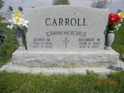
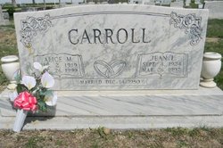
Delbert William Carroll
| Birth | : | 8 Jun 1920 Smithfield, Gosper County, Nebraska, USA |
| Death | : | 11 Aug 2012 Kearney, Buffalo County, Nebraska, USA |
| Burial | : | Greenwood Cemetery, Lexington, Dawson County, USA |
| Coordinate | : | 40.7956467, -99.7286682 |
| Plot | : | DIV. A, BLOCK 43, LOT 3, SPACE 1. |
| Description | : | Delbert William Carroll, 92, of Lexington, Nebraska, passed away Saturday, August 11, 2012, at Good Samaritan Hospital in Kearney. Delbert was born June 8, 1920, in Smithfield, Nebraska to Charles Dennis and Elizabeth Clara (Melosh) Carroll. Delbert moved with his family to rural Lexington as a young boy and then into town when he was in the 5th grade. He was a 1938, graduate of Lexington High School. Delbert was united in marriage to Doris Cryderman on May 25, 1948, at Lexington. Two daughters were blessed to this marriage; Peggy Ann and Christine Louise. Delbert spent his entire career building homes in... Read More |
frequently asked questions (FAQ):
-
Where is Delbert William Carroll's memorial?
Delbert William Carroll's memorial is located at: Greenwood Cemetery, Lexington, Dawson County, USA.
-
When did Delbert William Carroll death?
Delbert William Carroll death on 11 Aug 2012 in Kearney, Buffalo County, Nebraska, USA
-
Where are the coordinates of the Delbert William Carroll's memorial?
Latitude: 40.7956467
Longitude: -99.7286682
Family Members:
Parent

Spouse

Siblings
Flowers:


Nearby Cemetories:
1. First United Methodist Church Columbarium
Lexington, Dawson County, USA
Coordinate: 40.7810000, -99.7397000
2. Saint Anns Cemetery
Lexington, Dawson County, USA
Coordinate: 40.7789001, -99.7114029
3. Evergreen Cemetery
Lexington, Dawson County, USA
Coordinate: 40.7639008, -99.6791992
4. Mount Hope Cemetery
Dawson County, USA
Coordinate: 40.8293991, -99.6733017
5. Hewitt Cemetery
Lexington, Dawson County, USA
Coordinate: 40.8588982, -99.7769012
6. Buffalo Grove Presbyterian Church Cemetery
Buffalo, Dawson County, USA
Coordinate: 40.8721000, -99.8270000
7. Hillside Cemetery
Dawson County, USA
Coordinate: 40.8946991, -99.7869034
8. Grace Cemetery
Cozad, Dawson County, USA
Coordinate: 40.8602982, -99.8644028
9. Robb Cemetery
Smithfield, Gosper County, USA
Coordinate: 40.6710691, -99.6996001
10. Saint Johns Lutheran Cemetery
Lexington, Dawson County, USA
Coordinate: 40.9019012, -99.8458023
11. Plum Creek Massacre Cemetery
Phelps County, USA
Coordinate: 40.6726840, -99.6058220
12. Overton Cemetery
Overton, Dawson County, USA
Coordinate: 40.7317009, -99.5222015
13. Cozad Cemetery
Cozad, Dawson County, USA
Coordinate: 40.8605995, -99.9475021
14. Quakerville Cemetery
Gosper County, USA
Coordinate: 40.6189003, -99.8097000
15. Cottonwood Cemetery
Dawson County, USA
Coordinate: 40.9322014, -99.9197006
16. Saint Patricks Cemetery
Eddyville, Dawson County, USA
Coordinate: 40.9747009, -99.6093979
17. Adullam Cemetery
Bertrand, Phelps County, USA
Coordinate: 40.6265000, -99.5856000
18. Fairview Cemetery
Dawson County, USA
Coordinate: 40.7719002, -99.9955978
19. Jewell Cemetery
Sumner, Dawson County, USA
Coordinate: 40.9599991, -99.5646973
20. Rose Hill Cemetery
Dawson County, USA
Coordinate: 40.9888992, -99.8442001
21. Elwood Cemetery
Elwood, Gosper County, USA
Coordinate: 40.5999300, -99.8397300
22. Rhinehart Cemetery
Cozad, Dawson County, USA
Coordinate: 40.9599000, -99.9105000
23. Buffalo First Lutheran Cemetery Old
Buffalo, Dawson County, USA
Coordinate: 41.0100000, -99.8152000
24. Buffalo First Lutheran Cemetery New
Buffalo, Dawson County, USA
Coordinate: 41.0127000, -99.8150000