
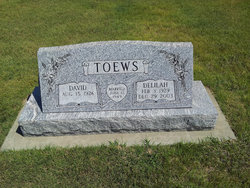
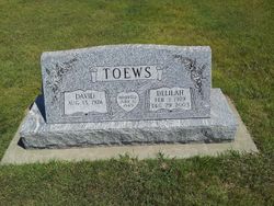
Delilah Dirks Toews
| Birth | : | 3 Feb 1929 Montezuma, Gray County, Kansas, USA |
| Death | : | 29 Dec 2003 Dodge City, Ford County, Kansas, USA |
| Burial | : | Homeland Mennonite Cemetery, Gray County, USA |
| Coordinate | : | 37.5469790, -100.4868440 |
frequently asked questions (FAQ):
-
Where is Delilah Dirks Toews's memorial?
Delilah Dirks Toews's memorial is located at: Homeland Mennonite Cemetery, Gray County, USA.
-
When did Delilah Dirks Toews death?
Delilah Dirks Toews death on 29 Dec 2003 in Dodge City, Ford County, Kansas, USA
-
Where are the coordinates of the Delilah Dirks Toews's memorial?
Latitude: 37.5469790
Longitude: -100.4868440
Family Members:
Parent
Spouse
Siblings
Children

Flowers:


Nearby Cemetories:
1. Homeland Mennonite Cemetery
Gray County, USA
Coordinate: 37.5469790, -100.4868440
2. Evans Cemetery
Gray County, USA
Coordinate: 37.5325012, -100.4777985
3. Morningside Cemetery
Montezuma, Gray County, USA
Coordinate: 37.5762900, -100.4337100
4. North Mennonite Cemetery
Montezuma, Gray County, USA
Coordinate: 37.6204400, -100.4781500
5. Copeland Cemetery
Copeland, Gray County, USA
Coordinate: 37.5461200, -100.6172700
6. Fairview Cemetery
Montezuma, Gray County, USA
Coordinate: 37.6431007, -100.4147034
7. Section 29 Gravesite
Haskell County, USA
Coordinate: 37.6008400, -100.6263100
8. Plains View Mennonite Church Cemetery
Plains, Meade County, USA
Coordinate: 37.4158710, -100.5076610
9. Section 1 Gravesite
Haskell County, USA
Coordinate: 37.5616100, -100.6526500
10. Lockport Cemetery
Haskell County, USA
Coordinate: 37.5912000, -100.6523400
11. Mertilla Cemetery
Meade County, USA
Coordinate: 37.3950100, -100.5612900
12. Section 2 Gravesite
Haskell County, USA
Coordinate: 37.4611700, -100.6718400
13. Colusa Cemetery
Haskell County, USA
Coordinate: 37.6632996, -100.6567001
14. Cave Cemetery
Gray County, USA
Coordinate: 37.5469017, -100.2518997
15. Salem Mennonite Cemetery
Copeland, Gray County, USA
Coordinate: 37.6465700, -100.6890600
16. Living Hope Mennonite Church Cemetery
Ingalls, Gray County, USA
Coordinate: 37.7311600, -100.5798300
17. Ensign Cemetery
Ensign, Gray County, USA
Coordinate: 37.6274986, -100.2339020
18. McCauley Cemetery
Fowler, Meade County, USA
Coordinate: 37.4609000, -100.2155800
19. First Congregational Church Cemetery
Fowler, Meade County, USA
Coordinate: 37.4606400, -100.2152600
20. Lockhart Cemetery
Meade County, USA
Coordinate: 37.3436012, -100.3167038
21. Johnson Cemetery
Ensign, Gray County, USA
Coordinate: 37.7086010, -100.2156130
22. Fowler Cemetery
Fowler, Meade County, USA
Coordinate: 37.3732986, -100.2018967
23. Cimarron Cemetery
Cimarron, Gray County, USA
Coordinate: 37.8178200, -100.3411900
24. Graceland Cemetery
Meade, Meade County, USA
Coordinate: 37.2844009, -100.3189011