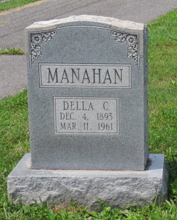
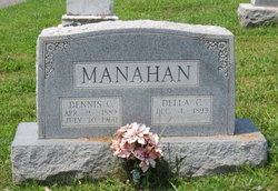
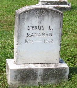
Della Catherine Smith Manahan
| Birth | : | 1894 Frederick County, Maryland, USA |
| Death | : | 11 Mar 1961 Emmitsburg, Frederick County, Maryland, USA |
| Burial | : | Zion Methodist Cemetery, Zion, Cecil County, USA |
| Coordinate | : | 39.6761470, -75.9656630 |
| Description | : | WOMAN FOUND DEAD IN HOME ON SATURDAY Mrs. Della Catherine Manahan, 67, was found dead in her Emmitsburg home Saturday. Dr. B.O. Thomas, Frederick County deputy medical examiner, said the death was a suicide by self-inflicted shotgun wounds. He placed the time of death at 6 o'clock Saturday morning. A son, Cyrus Manahan, who resided with his mother, left for work about 5:30 o'clock Saturday morning. A neighbor found the house locked later Saturday morning notified other relatives who called the son at his work. When he arrived home and entered he found his mother dead. A native of Frederick County, she was... Read More |
frequently asked questions (FAQ):
-
Where is Della Catherine Smith Manahan's memorial?
Della Catherine Smith Manahan's memorial is located at: Zion Methodist Cemetery, Zion, Cecil County, USA.
-
When did Della Catherine Smith Manahan death?
Della Catherine Smith Manahan death on 11 Mar 1961 in Emmitsburg, Frederick County, Maryland, USA
-
Where are the coordinates of the Della Catherine Smith Manahan's memorial?
Latitude: 39.6761470
Longitude: -75.9656630
Family Members:
Parent
Spouse
Siblings
Children
Flowers:
Nearby Cemetories:
1. Zion Methodist Cemetery
Zion, Cecil County, USA
Coordinate: 39.6761470, -75.9656630
2. Zion Presbyterian Cemetery
Zion, Cecil County, USA
Coordinate: 39.6767370, -75.9666900
3. Trinity Cemetery
Zion, Cecil County, USA
Coordinate: 39.6805992, -75.9816971
4. Rosebank Cemetery
Calvert, Cecil County, USA
Coordinate: 39.7010994, -75.9805984
5. Brick Meeting House Cemetery
Calvert, Cecil County, USA
Coordinate: 39.7011700, -75.9819800
6. Bay View Cemetery
Bay View, Cecil County, USA
Coordinate: 39.6449700, -75.9617500
7. Ebenezer Cemetery
Rising Sun, Cecil County, USA
Coordinate: 39.6585600, -76.0102800
8. State Line Baptist Church Cemetery
Rising Sun, Cecil County, USA
Coordinate: 39.7205567, -75.9780979
9. Logan Family Cemetery
Bay View, Cecil County, USA
Coordinate: 39.6301200, -75.9619200
10. Moores Chapel United Methodist Church Cemetery
Elkton, Cecil County, USA
Coordinate: 39.7125015, -75.9233017
11. Union Cemetery
Elkton, Cecil County, USA
Coordinate: 39.6472015, -75.9105988
12. Calvary Missionary Baptist Church Cemetery
Rising Sun, Cecil County, USA
Coordinate: 39.7028200, -76.0263000
13. Mount Olivet Methodist Protestant Church Cemetery
East Nottingham Township, Chester County, USA
Coordinate: 39.7311500, -75.9665200
14. Mount Rocky Methodist Episcopal Cemetery
Elk Township, Chester County, USA
Coordinate: 39.7256550, -75.9336410
15. Griffith Cemetery
Providence, Cecil County, USA
Coordinate: 39.6785500, -75.8910800
16. Bethel United Methodist Church Cemetery
Bay View, Cecil County, USA
Coordinate: 39.6156400, -75.9852000
17. Boulden Chapel Cemetery
Cecil County, USA
Coordinate: 39.6258011, -75.9011002
18. Leeds Cemetery
Elkton, Cecil County, USA
Coordinate: 39.6549988, -75.8764038
19. Bible Evangelical Church Cemetery
Oxford, Chester County, USA
Coordinate: 39.7494570, -75.9570070
20. Mount Carmel Baptist Cemetery
Cecil County, USA
Coordinate: 39.6048500, -75.9403500
21. Little Elk Friends Meeting Cemetery
Hickory Hill, Chester County, USA
Coordinate: 39.7482986, -75.9310989
22. Hopewell United Methodist Church Cemetery
Woodlawn, Cecil County, USA
Coordinate: 39.6456108, -76.0590820
23. Saint John's Cemetery
Elkton, Cecil County, USA
Coordinate: 39.7200012, -75.8764038
24. Saint Mary Annes Episcopal Church Cemetery
North East, Cecil County, USA
Coordinate: 39.5966454, -75.9419403

