
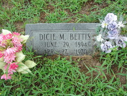
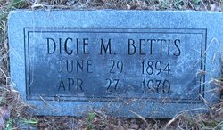
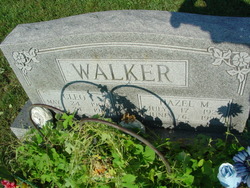
Dicie Melvina Walker Bettis
| Birth | : | 29 Jun 1894 Missouri, USA |
| Death | : | 27 Apr 1970 Mountain View, Howell County, Missouri, USA |
| Burial | : | Common Burying Ground, Newport, Newport County, USA |
| Coordinate | : | 41.4959564, -71.3165741 |
frequently asked questions (FAQ):
-
Where is Dicie Melvina Walker Bettis's memorial?
Dicie Melvina Walker Bettis's memorial is located at: Common Burying Ground, Newport, Newport County, USA.
-
When did Dicie Melvina Walker Bettis death?
Dicie Melvina Walker Bettis death on 27 Apr 1970 in Mountain View, Howell County, Missouri, USA
-
Where are the coordinates of the Dicie Melvina Walker Bettis's memorial?
Latitude: 41.4959564
Longitude: -71.3165741
Family Members:
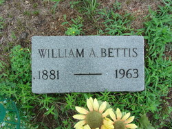
Parent
Spouse
Siblings
Children

Flowers:


Nearby Cemetories:
1. Common Burying Ground
Newport, Newport County, USA
Coordinate: 41.4959564, -71.3165741
2. Braman Cemetery
Newport, Newport County, USA
Coordinate: 41.4956360, -71.3169098
3. God's Little Acre Cemetery
Newport, Newport County, USA
Coordinate: 41.4965150, -71.3163130
4. Willow Cemetery
Newport, Newport County, USA
Coordinate: 41.4949890, -71.3164650
5. North Burial Ground
Newport, Newport County, USA
Coordinate: 41.4981270, -71.3170700
6. Island Cemetery
Newport, Newport County, USA
Coordinate: 41.4956589, -71.3135605
7. Saint Marys Cemetery
Newport, Newport County, USA
Coordinate: 41.4971085, -71.3135147
8. Friends Cemetery
Newport, Newport County, USA
Coordinate: 41.4934807, -71.3136826
9. Coddington Cemetery
Newport, Newport County, USA
Coordinate: 41.4923706, -71.3143616
10. John Clarke Cemetery
Newport, Newport County, USA
Coordinate: 41.4937897, -71.3112869
11. Malboro Street Tomb (Defunct)
Newport, Newport County, USA
Coordinate: 41.4911110, -71.3136110
12. Bliss-Pierce Lot
Newport, Newport County, USA
Coordinate: 41.4941140, -71.3090260
13. Dyre Family Burial Ground (Defunct)
Newport, Newport County, USA
Coordinate: 41.5016070, -71.3209220
14. First Sabbatarian Church of Newport Cemetery
Newport, Newport County, USA
Coordinate: 41.4891701, -71.3116379
15. Barney Street Cemetery
Newport, Newport County, USA
Coordinate: 41.4893608, -71.3109818
16. Goat Island Pirate Graves
Newport, Newport County, USA
Coordinate: 41.4928600, -71.3269300
17. Goat Island Burial Ground
Newport, Newport County, USA
Coordinate: 41.4930330, -71.3272510
18. Trinity Church Cemetery
Newport, Newport County, USA
Coordinate: 41.4874229, -71.3131180
19. Moravian Church Lot
Newport, Newport County, USA
Coordinate: 41.4874190, -71.3113130
20. Colonial Jewish Cemetery of Rhode Island
Newport, Newport County, USA
Coordinate: 41.4879265, -71.3093567
21. First Congregational Churchyard (Defunct)
Newport, Newport County, USA
Coordinate: 41.4864020, -71.3119910
22. Governor Arnold Burying Ground
Newport, Newport County, USA
Coordinate: 41.4861300, -71.3119900
23. Newport Congregational Church Cemetery
Newport, Newport County, USA
Coordinate: 41.4857674, -71.3128662
24. Judge Anthony Wilbur Cemetery
Newport, Newport County, USA
Coordinate: 41.4989600, -71.3018300