
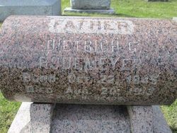
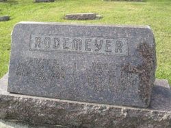
Dietrich G. “Dick” Rodemeyer
| Birth | : | 22 Oct 1845 Germany |
| Death | : | 20 Aug 1913 Latimer, Franklin County, Iowa, USA |
| Burial | : | Saint Pauls Evangelical Lutheran Cemetery, Latimer, Franklin County, USA |
| Coordinate | : | 42.7652817, -93.3719406 |
| Description | : | Two things on this person - his death record is under Richard Rodemeyer with these dates - thus the nickname Dick I would guess. He is listed as the son of Dietrich Rodemeyer of Germany & Sofia Holkle Contributor: Jacki Bierma (47657130) • [email protected] |
frequently asked questions (FAQ):
-
Where is Dietrich G. “Dick” Rodemeyer's memorial?
Dietrich G. “Dick” Rodemeyer's memorial is located at: Saint Pauls Evangelical Lutheran Cemetery, Latimer, Franklin County, USA.
-
When did Dietrich G. “Dick” Rodemeyer death?
Dietrich G. “Dick” Rodemeyer death on 20 Aug 1913 in Latimer, Franklin County, Iowa, USA
-
Where are the coordinates of the Dietrich G. “Dick” Rodemeyer's memorial?
Latitude: 42.7652817
Longitude: -93.3719406
Family Members:
Parent

Spouse
Siblings
Children
Flowers:


Nearby Cemetories:
1. Saint Pauls Evangelical Lutheran Cemetery
Latimer, Franklin County, USA
Coordinate: 42.7652817, -93.3719406
2. Coulter Cemetery
Coulter, Franklin County, USA
Coordinate: 42.7388916, -93.3716736
3. Marion Center Cemetery
Latimer, Franklin County, USA
Coordinate: 42.7738991, -93.3178024
4. Saint Peter's Lutheran Church Cemetery
Coulter, Franklin County, USA
Coordinate: 42.7167015, -93.3803024
5. Saint Johns Lutheran Cemetery
Hampton, Franklin County, USA
Coordinate: 42.7197189, -93.3397217
6. Alexander Cemetery
Alexander, Franklin County, USA
Coordinate: 42.8041687, -93.4591675
7. Zion Reformed Church Cemetery
Franklin County, USA
Coordinate: 42.8413887, -93.3188934
8. Trinity Lutheran Cemetery
Hampton, Franklin County, USA
Coordinate: 42.7667007, -93.2518997
9. Morgan Cemetery
Morgan Township, Franklin County, USA
Coordinate: 42.6741982, -93.4100037
10. Old Chapin Cemetery
Chapin, Franklin County, USA
Coordinate: 42.8232994, -93.2624969
11. Mount Hope Cemetery
Morgan Township, Franklin County, USA
Coordinate: 42.6777992, -93.4792023
12. Holland Cemetery
Wisner Township, Franklin County, USA
Coordinate: 42.8638916, -93.4791718
13. Way Side Cemetery
Chapin, Franklin County, USA
Coordinate: 42.8293991, -93.2225037
14. Hampton Cemetery
Hampton, Franklin County, USA
Coordinate: 42.7452812, -93.1975021
15. Olson Cemetery
Popejoy, Franklin County, USA
Coordinate: 42.6383018, -93.4403000
16. Maynes Grove Cemetery
Hampton, Franklin County, USA
Coordinate: 42.6577988, -93.2514038
17. Richland Lutheran Cemetery
Thornton, Cerro Gordo County, USA
Coordinate: 42.9086113, -93.3683319
18. Graceland Cemetery
Rowan, Wright County, USA
Coordinate: 42.7453003, -93.5714035
19. Fairview Cemetery
Dows, Wright County, USA
Coordinate: 42.6511002, -93.5044022
20. Shobes Grove Cemetery
Franklin County, USA
Coordinate: 42.9000015, -93.2722168
21. Immanuel Reformed Cemetery
Belmond, Wright County, USA
Coordinate: 42.8635000, -93.5484000
22. Meservey Cemetery
Meservey, Franklin County, USA
Coordinate: 42.9080582, -93.4786072
23. Towle Cemetery
Geneva, Franklin County, USA
Coordinate: 42.6836014, -93.1785965
24. Richard Cemetery
Meservey, Cerro Gordo County, USA
Coordinate: 42.9089012, -93.4925003