
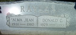
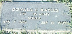
Donald Carlyle Rayles
| Birth | : | 7 Apr 1929 Vevay, Switzerland County, Indiana, USA |
| Death | : | 12 Sep 1995 Louisville, Jefferson County, Kentucky, USA |
| Burial | : | Whatcoat United Methodist Cemetery, Snow Hill, Worcester County, USA |
| Coordinate | : | 38.1751500, -75.3904100 |
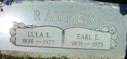
| Description | : | ♥♥♥♥♥♥♥♥♥♥♥♥♥♥♥♥♥♥♥♥♥♥♥♥♥♥♥♥♥♥♥♥♥♥♥♥♥♥♥♥♥♥♥♥♥♥♥♥♥♥ ☆☆☆~ Korean War Veteran ~☆☆☆ ♥♥♥♥♥♥♥♥♥♥♥♥♥♥♥♥♥♥♥♥♥♥♥♥♥♥♥♥♥♥♥♥♥♥♥♥♥♥♥♥♥♥♥♥♥♥♥♥♥♥ Vevay Reveille Enterprise---September 14, 1995 Donald C. Rayles, 66, of 500 E. Seminary St., Vevay, passed away Tuesday, September 12th, at Jewish Hospital in Louisville after a short illness. He was born April 7th, 1929, in Vevay, Indiana, the son of Earl E. "Skinny" Rayles and Lula E. McCreary. He was a U.S. Army veteran of the Korean War. He worked for the Ford Garage in Vevay as Parts Manager for 27 years. He was a former employee of the Town of Vevay and a former co-owner of the Phillips 66 Service... Read More |
frequently asked questions (FAQ):
-
Where is Donald Carlyle Rayles's memorial?
Donald Carlyle Rayles's memorial is located at: Whatcoat United Methodist Cemetery, Snow Hill, Worcester County, USA.
-
When did Donald Carlyle Rayles death?
Donald Carlyle Rayles death on 12 Sep 1995 in Louisville, Jefferson County, Kentucky, USA
-
Where are the coordinates of the Donald Carlyle Rayles's memorial?
Latitude: 38.1751500
Longitude: -75.3904100
Family Members:
Parent

Spouse

Siblings


Nearby Cemetories:
1. Whatcoat United Methodist Cemetery
Snow Hill, Worcester County, USA
Coordinate: 38.1751500, -75.3904100
2. Old School Baptist Church Cemetery
Snow Hill, Worcester County, USA
Coordinate: 38.1748410, -75.3910290
3. Makemie Memorial Cemetery
Snow Hill, Worcester County, USA
Coordinate: 38.1755981, -75.3938980
4. All Hallows Cemetery
Snow Hill, Worcester County, USA
Coordinate: 38.1755981, -75.3946991
5. Christian Cemetery
Snow Hill, Worcester County, USA
Coordinate: 38.1810989, -75.3874969
6. Bates Methodist Church Cemetery
Snow Hill, Worcester County, USA
Coordinate: 38.1708600, -75.3991500
7. Mount Zion Cemetery
Snow Hill, Worcester County, USA
Coordinate: 38.1706009, -75.4036026
8. Nelson-Stevenson Cemetery
Snow Hill, Worcester County, USA
Coordinate: 38.1436510, -75.4074846
9. Ebenezer Cemetery
Snow Hill, Worcester County, USA
Coordinate: 38.1719017, -75.3455963
10. Hutt Chapel Cemetery
Worcester County, USA
Coordinate: 38.1935997, -75.4468994
11. Nassawango Cemetery
Worcester County, USA
Coordinate: 38.1889000, -75.4496994
12. Waters Cemetery
Mount Vernon, Somerset County, USA
Coordinate: 38.1600000, -75.4600000
13. Taylor Gate Cemetery
Snow Hill, Worcester County, USA
Coordinate: 38.2318993, -75.4047012
14. Spence Baptist Church Cemetery
Spence, Worcester County, USA
Coordinate: 38.1612673, -75.3139438
15. Coolspring United Methodist Church Cemetery
Girdletree, Worcester County, USA
Coordinate: 38.1124992, -75.3908005
16. Spring Hill Cemetery
Worcester County, USA
Coordinate: 38.1044006, -75.3961029
17. Green Acres Cemetery
Worcester County, USA
Coordinate: 38.1361008, -75.2992020
18. Beth Eden - Tilghman Hill Cemetery
Worcester County, USA
Coordinate: 38.1150017, -75.4621964
19. Betheden Cemetery
Worcester County, USA
Coordinate: 38.1114006, -75.4608002
20. Collins Family Cemetery
Snow Hill, Worcester County, USA
Coordinate: 38.2614690, -75.3921880
21. Old Trinity Cemetery
Worcester County, USA
Coordinate: 38.2360992, -75.3082962
22. Mount Olive Cemetery
Snow Hill, Worcester County, USA
Coordinate: 38.2552986, -75.4432983
23. Saint Lukes Cemetery
Worcester County, USA
Coordinate: 38.0960999, -75.4531021
24. Mount Zion United Methodist Cemetery
Whiton, Worcester County, USA
Coordinate: 38.2681700, -75.3827300