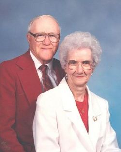
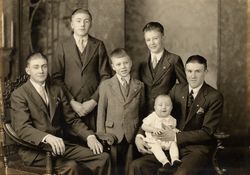
Donald H. Lienemann
| Birth | : | 1 Oct 1917 Papillion, Sarpy County, Nebraska, USA |
| Death | : | 22 Dec 2006 Nebraska, USA |
| Burial | : | Sacred Heart Cemetery, Ironton, Lawrence County, USA |
| Coordinate | : | 38.5447006, -82.6631012 |
| Inscription | : | Donald H Lienemann 2nd Lieutenant US Army Air Forces World War II Oct 1 1917 - Dec 22 2006 Purple Heart |
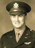
| Description | : | Lt. Don Lienemann served as an 8th Air Force navigator. He survived the explosion of his B-17G Flying Fortress during an attack by German fighter planes over Germany on Sept. 11, 1944. Lt. Lienemann was taken prisoner and transported to Stalag One, Barth, Germany. He spent the remainder of the war as a POW. In his later years, Mr. Lienemann wrote "Miracles Do Happen: A B-17 Navigator's Story of the September 11, 1944, Mission to Destory the Ruhland, Germany Oil Refinery and His Prison Camp Experience in Stalag Luft I", published by Morris Publishing (NE) (January 2003). |
frequently asked questions (FAQ):
-
Where is Donald H. Lienemann's memorial?
Donald H. Lienemann's memorial is located at: Sacred Heart Cemetery, Ironton, Lawrence County, USA.
-
When did Donald H. Lienemann death?
Donald H. Lienemann death on 22 Dec 2006 in Nebraska, USA
-
Where are the coordinates of the Donald H. Lienemann's memorial?
Latitude: 38.5447006
Longitude: -82.6631012
Family Members:
Parent
Spouse
Siblings
Flowers:
Nearby Cemetories:
1. Hecla Cemetery
Hecla, Lawrence County, USA
Coordinate: 38.5492700, -82.6433400
2. W.D. Kelly Cemetery
Ironton, Lawrence County, USA
Coordinate: 38.5284700, -82.6661200
3. Henry Cemetery
Ironton, Lawrence County, USA
Coordinate: 38.5476190, -82.6855840
4. Lagrange Cemetery
Ironton, Lawrence County, USA
Coordinate: 38.5665300, -82.6719800
5. Sugar Creek Cemetery
Ironton, Lawrence County, USA
Coordinate: 38.5467700, -82.6282000
6. Pigeon Hollow Cemetery
Hanging Rock, Lawrence County, USA
Coordinate: 38.5668260, -82.6968610
7. Jenkins Cemetery
Hanging Rock, Lawrence County, USA
Coordinate: 38.5630490, -82.7067410
8. Woodland Cemetery
Ironton, Lawrence County, USA
Coordinate: 38.5069008, -82.6502991
9. Calvary Cemetery
Coal Grove, Lawrence County, USA
Coordinate: 38.5056000, -82.6474991
10. Newton Cemetery
Coal Grove, Lawrence County, USA
Coordinate: 38.5024986, -82.6492004
11. Hanging Rock Cemetery
Hanging Rock, Lawrence County, USA
Coordinate: 38.5642014, -82.7136002
12. Bellefonte Memorial Gardens
Flatwoods, Greenup County, USA
Coordinate: 38.5153008, -82.7052994
13. Palmer Cemetery
Flatwoods, Greenup County, USA
Coordinate: 38.5141983, -82.7055969
14. Sheeler Cemetery
Bellefonte, Greenup County, USA
Coordinate: 38.4962279, -82.6763369
15. Zoar Cemetery
Coal Grove, Lawrence County, USA
Coordinate: 38.5010986, -82.6280975
16. Palmer Cemetery #1
Flatwoods, Greenup County, USA
Coordinate: 38.5177280, -82.7213730
17. Huffman Cemetery
Argillite, Greenup County, USA
Coordinate: 38.5354904, -82.7344360
18. Rude Cemetery
Flatwoods, Greenup County, USA
Coordinate: 38.5242004, -82.7311020
19. Hackworth Cemetery
Lawrence Township, Lawrence County, USA
Coordinate: 38.5408060, -82.5836320
20. Crabtree Family Cemetery
Kitts Hill, Lawrence County, USA
Coordinate: 38.4907280, -82.6183990
21. Beech Grove Cemetery
Ashland, Boyd County, USA
Coordinate: 38.4802610, -82.6483320
22. Baldridge Cemetery #1
Flatwoods, Greenup County, USA
Coordinate: 38.5083008, -82.7328033
23. Community Cemetery
Deering, Lawrence County, USA
Coordinate: 38.5010250, -82.6005050
24. Mamre Cemetery
Kitts Hill, Lawrence County, USA
Coordinate: 38.5623016, -82.5814972

