

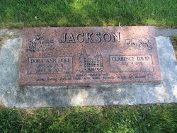
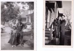
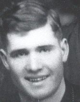
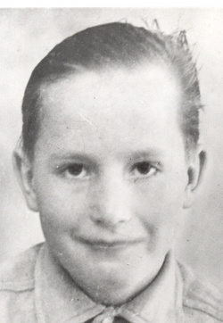
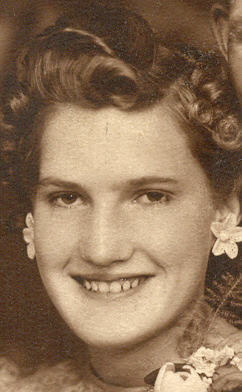
Dora Ann Hoke Jackson
| Birth | : | 26 Jan 1924 Washoe, Carbon County, Montana, USA |
| Death | : | 4 Sep 2007 Belfry, Carbon County, Montana, USA |
| Burial | : | St. Thomas Anglican Cemetery, Enfield, Burwood Municipality, Australia |
| Coordinate | : | -33.8912070, 151.0916610 |
| Description | : | Published in the Billings Gazette on 9/7/2007. BELFRY - Dora Ann Hoke Jackson, 83, our beloved wife, mother, grandmother and great-grandmother, returned home to her Father in heaven on Tuesday, Sept. 4, 2007. Dora was born to Jesse Lee Hoke and Alta Copple Hoke on Jan. 26, 1924, in Washoe, Mont. She attended school in Washoe and graduated from Belfry High School. Dora married Clarence Jackson on March 31, 1943, in the Salt Lake LDS Temple in Salt Lake City. They settled on their farm near Belfry. She was a wonderful mother and homemaker, serving her family, church and community. Dora was delighted when... Read More |
frequently asked questions (FAQ):
-
Where is Dora Ann Hoke Jackson's memorial?
Dora Ann Hoke Jackson's memorial is located at: St. Thomas Anglican Cemetery, Enfield, Burwood Municipality, Australia.
-
When did Dora Ann Hoke Jackson death?
Dora Ann Hoke Jackson death on 4 Sep 2007 in Belfry, Carbon County, Montana, USA
-
Where are the coordinates of the Dora Ann Hoke Jackson's memorial?
Latitude: -33.8912070
Longitude: 151.0916610
Family Members:
Parent
Spouse
Siblings

Flowers:

As you wavered between this life and the next on Tuesday, Sept 4th, you foresaw my frightening auto crash just a few hours in advance. Angels miracoulsy attended me that I might walk away unscathed. Perhaps you were one of them. Love Always & Forever.
Left by Anonymous on 16 Sep 2007

Left by Anonymous on 22 Jan 2015

Left by Anonymous on 19 May 2020


Nearby Cemetories:
1. St. Thomas Anglican Cemetery
Enfield, Burwood Municipality, Australia
Coordinate: -33.8912070, 151.0916610
2. St Paul's Anglican Church
Burwood, Burwood Municipality, Australia
Coordinate: -33.8816114, 151.1027492
3. St. Mary's Roman Catholic Church Cemetery
Concord, Canada Bay City, Australia
Coordinate: -33.8677100, 151.1024300
4. St. Luke's Anglican Church Columbarium
Concord, Canada Bay City, Australia
Coordinate: -33.8678417, 151.1068448
5. Sydney Memorial
Rookwood, Cumberland Council, Australia
Coordinate: -33.8773100, 151.0642800
6. Sydney War Cemetery
Rookwood, Cumberland Council, Australia
Coordinate: -33.8769700, 151.0636100
7. New South Wales Cremation Memorial
Rookwood, Cumberland Council, Australia
Coordinate: -33.8776400, 151.0627700
8. New South Wales Garden of Remembrance
Rookwood, Cumberland Council, Australia
Coordinate: -33.8776400, 151.0627700
9. Rookwood Memorial Gardens and Crematorium
Rookwood, Cumberland Council, Australia
Coordinate: -33.8768500, 151.0598900
10. St. Paul's Anglican Church Cemetery
Canterbury, Canterbury-Bankstown Council, Australia
Coordinate: -33.9081600, 151.1236000
11. St. John's Anglican Church Cemetery
Ashfield, Inner West Council, Australia
Coordinate: -33.8817160, 151.1278730
12. Rookwood General Cemetery
Rookwood, Cumberland Council, Australia
Coordinate: -33.8740500, 151.0591100
13. Longbottom Cemetery
Concord, Canada Bay City, Australia
Coordinate: -33.8596140, 151.0986280
14. Rookwood Catholic Cemeteries and Crematoria
Rookwood, Cumberland Council, Australia
Coordinate: -33.8793500, 151.0547850
15. St David’s Presbyterian Cemetery
Haberfield, Inner West Council, Australia
Coordinate: -33.8823220, 151.1378500
16. Moorefields Methodist Cemetery
Kingsgrove, Canterbury-Bankstown Council, Australia
Coordinate: -33.9343560, 151.0904450
17. St Thomas Becket Churchyard
Lewisham, Inner West Council, Australia
Coordinate: -33.8928760, 151.1480490
18. Saint Felix de Valois-Catholic Church Cemetery
Bankstown, Canterbury-Bankstown Council, Australia
Coordinate: -33.9076100, 151.0351850
19. St. Saviour's Church of England Cemetery
Punchbowl, Canterbury-Bankstown Council, Australia
Coordinate: -33.9311480, 151.0552250
20. Balmain Catholic Cemetery (Defunct)
Leichhardt, Inner West Council, Australia
Coordinate: -33.8797270, 151.1523730
21. Pioneers Memorial Park
Leichhardt, Inner West Council, Australia
Coordinate: -33.8780800, 151.1575000
22. Gladesville Asylum Cemetery
Gladesville, Hunter's Hill Municipality, Australia
Coordinate: -33.8393010, 151.1342490
23. St Luke's Anglican Church
Enmore, Inner West Council, Australia
Coordinate: -33.8989218, 151.1700724
24. Rockdale Uniting Church Cemetery
Rockdale, Bayside Council, Australia
Coordinate: -33.9533350, 151.1381840