
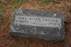
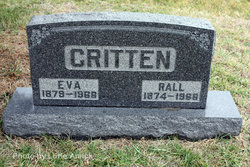
Dora Ellen Critten
| Birth | : | 26 Apr 1863 Licking County, Ohio, USA |
| Death | : | 2 Dec 1952 Hammond, Lake County, Indiana, USA |
| Burial | : | Oakwood Cemetery, Mount Morris, Ogle County, USA |
| Coordinate | : | 42.0483017, -89.4580994 |
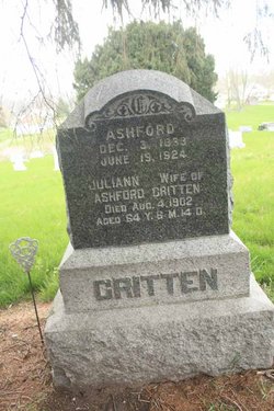
| Description | : | The Monon News, Thursday, December 11, 1952 BODY OF FORMER RESIDENT RETURNED FOR BURIAL HERE Dora Ellen Critten Expired Dec. 2nd in Hammond Dora Ellen Critten, 89 year old former Monon resident, passed away Tuesday of last week at the Hammond home of her neice, Mrs. B.C. McKown, following a stroke. Miss Critten was born in Licking County, Ohio, April 25, 1863, the daughter of Ashford and Julia Ann Critten and came to Monon from Licking County in 1886. For 30 years, she made her home here, moving to Hammond in 1925. She was a member of the Monon Baptist Church. Funeral services were held... Read More |
frequently asked questions (FAQ):
-
Where is Dora Ellen Critten's memorial?
Dora Ellen Critten's memorial is located at: Oakwood Cemetery, Mount Morris, Ogle County, USA.
-
When did Dora Ellen Critten death?
Dora Ellen Critten death on 2 Dec 1952 in Hammond, Lake County, Indiana, USA
-
Where are the coordinates of the Dora Ellen Critten's memorial?
Latitude: 42.0483017
Longitude: -89.4580994
Family Members:
Parent

Siblings
Flowers:


Nearby Cemetories:
1. Oakwood Cemetery
Mount Morris, Ogle County, USA
Coordinate: 42.0483017, -89.4580994
2. Plainview Cemetery
Mount Morris, Ogle County, USA
Coordinate: 42.0424995, -89.4366989
3. Cedar Hill Cemetery
Mount Morris, Ogle County, USA
Coordinate: 42.0158005, -89.4238968
4. Silver Creek Cemetery
Leaf River, Ogle County, USA
Coordinate: 42.0928001, -89.4083023
5. Rice Cemetery
Mount Morris, Ogle County, USA
Coordinate: 42.1061172, -89.4517136
6. Coffman Family Farm Grounds
Stratford, Ogle County, USA
Coordinate: 41.9960556, -89.4936142
7. West Branch Cemetery
Haldane, Ogle County, USA
Coordinate: 42.0630989, -89.5355988
8. Mount Zion Cemetery
Oregon, Ogle County, USA
Coordinate: 41.9930992, -89.4044037
9. Camling Cemetery
Leaf River, Ogle County, USA
Coordinate: 42.0882988, -89.3758011
10. West Grove Cemetery
Forreston, Ogle County, USA
Coordinate: 42.0997887, -89.5292435
11. Saint Mary's Cemetery
Oregon, Ogle County, USA
Coordinate: 42.0032997, -89.3767014
12. Saint Brides Episcopal Cemetery
Oregon, Ogle County, USA
Coordinate: 42.0270271, -89.3536911
13. Haldane Cemetery
Haldane, Ogle County, USA
Coordinate: 42.0691986, -89.5706024
14. Riverview Cemetery
Oregon, Ogle County, USA
Coordinate: 42.0275002, -89.3399963
15. Better Place Forest
Ogle County, USA
Coordinate: 42.0411546, -89.3341425
16. Pine Creek Brethren Cemetery
Pine Creek Township, Ogle County, USA
Coordinate: 41.9538879, -89.4750824
17. Adeline Cemetery
Adeline, Ogle County, USA
Coordinate: 42.1434708, -89.4943466
18. Riverside Cemetery
Oregon, Ogle County, USA
Coordinate: 42.0177994, -89.3308029
19. Fairmount Cemetery
Polo, Ogle County, USA
Coordinate: 42.0005989, -89.5766983
20. Saint Mary Cemetery
Polo, Ogle County, USA
Coordinate: 41.9989014, -89.5777969
21. Brooklyn Cemetery
Oregon, Ogle County, USA
Coordinate: 42.0668907, -89.3221283
22. Lightsville Cemetery
Leaf River, Ogle County, USA
Coordinate: 42.1443100, -89.4085007
23. Evergreen Cemetery
Polo, Ogle County, USA
Coordinate: 41.9446678, -89.4941101
24. County Farm Cemetery
Oregon, Ogle County, USA
Coordinate: 41.9919014, -89.3328018