
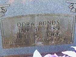
Dora L. Stobaugh Bonds
| Birth | : | 31 Jan 1889 Van Buren County, Arkansas, USA |
| Death | : | 5 Dec 1966 Van Buren County, Arkansas, USA |
| Burial | : | Church of the Brethren Cemetery, Amoy, Richland County, USA |
| Coordinate | : | 40.8495026, -82.5425034 |
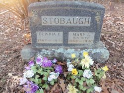
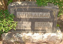
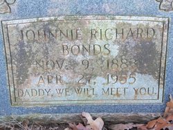
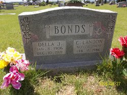
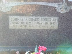
| Description | : | Dora was the daughter of Elisha Franklin Stobaugh and Mary L. Sloan Ayers Stobaugh. She married Johnnie Richard Bonds on December 23, 1905 in Van Buren Co., Arkansas. Dora and Johnnie were the parents of 1.Cyrus Landon Bonds, b.November 04, 1909, d.February 16, 1986. Cyrus married 1.Della J. Crawford, 2.Esther Mae Tiner. Cyrus and Della are interred at Union Hill Cemetery, Formosa, Van Buren Co., Arkansas. 2.Johnny Richard Bonds, Jr., b.June 10, 1928, d.May 20, 1953. Johnny married Mary Lou Blankenship. Johnny and Mary Lou are interred here at Huie Cemetery. ****************************** |
frequently asked questions (FAQ):
-
Where is Dora L. Stobaugh Bonds's memorial?
Dora L. Stobaugh Bonds's memorial is located at: Church of the Brethren Cemetery, Amoy, Richland County, USA.
-
When did Dora L. Stobaugh Bonds death?
Dora L. Stobaugh Bonds death on 5 Dec 1966 in Van Buren County, Arkansas, USA
-
Where are the coordinates of the Dora L. Stobaugh Bonds's memorial?
Latitude: 40.8495026
Longitude: -82.5425034
Family Members:
Parent
Spouse
Siblings

Children
Flowers:


Nearby Cemetories:
1. Church of the Brethren Cemetery
Amoy, Richland County, USA
Coordinate: 40.8495026, -82.5425034
2. Boyce Cemetery
Taylortown, Richland County, USA
Coordinate: 40.8578170, -82.5437590
3. Lynn - Whisler Cemetery
Mansfield, Richland County, USA
Coordinate: 40.8494220, -82.5218170
4. Clay Memorial Cemetery
Mansfield, Richland County, USA
Coordinate: 40.8286830, -82.5381270
5. Pleasant Valley Baptist Cemetery
Mansfield, Richland County, USA
Coordinate: 40.8506012, -82.5134964
6. Zeiter Cemetery
Franklin Township, Richland County, USA
Coordinate: 40.8286018, -82.5149994
7. Franklin Cemetery
Mansfield, Richland County, USA
Coordinate: 40.8586671, -82.4812796
8. Osbun-Pittenger Cemetery
Mansfield, Richland County, USA
Coordinate: 40.8301910, -82.4845270
9. Bly Farm Cemetery
Mansfield, Richland County, USA
Coordinate: 40.8976560, -82.5383750
10. Mount Bethel Cemetery
Jackson Township, Richland County, USA
Coordinate: 40.8427811, -82.6058273
11. Missionaries of the Sacred Heart Cemetery
Shelby, Richland County, USA
Coordinate: 40.8328200, -82.6033870
12. Richland Cemetery
Mansfield, Richland County, USA
Coordinate: 40.8435290, -82.4781150
13. Spring Mill Cemetery
Mansfield, Richland County, USA
Coordinate: 40.8052060, -82.5836890
14. Ganges Cemetery
Ganges, Richland County, USA
Coordinate: 40.9049034, -82.5616302
15. Shenandoah Church Cemetery
Shenandoah, Richland County, USA
Coordinate: 40.9095573, -82.4995117
16. Ohio State Reformatory Cemetery
Mansfield, Richland County, USA
Coordinate: 40.7875460, -82.5028690
17. London Cemetery
Shelby, Richland County, USA
Coordinate: 40.8860207, -82.6218033
18. Rome East Cemetery
Rome, Richland County, USA
Coordinate: 40.9238091, -82.5310745
19. Charles-Vantilburg Cemetery
Epworth, Richland County, USA
Coordinate: 40.8551445, -82.4379272
20. Barr Cemetery
Mansfield, Richland County, USA
Coordinate: 40.7736220, -82.5742470
21. Pavonia Cemetery
Weller Township, Richland County, USA
Coordinate: 40.8246040, -82.4424370
22. Rome Presbyterian Church Civil War Cemetery
Shiloh, Richland County, USA
Coordinate: 40.9313730, -82.5383100
23. Rome Presbyterian Church Revolutionary War Cemeter
Rome, Richland County, USA
Coordinate: 40.9318581, -82.5366058
24. Painter Gravesite
Mansfield, Richland County, USA
Coordinate: 40.7700600, -82.4968400