

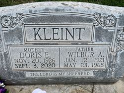
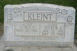
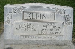
Doris Ellen Meints Brown
| Birth | : | 20 Nov 1926 Hitchcock County, Nebraska, USA |
| Death | : | 3 Sep 2020 Lexington, Dawson County, Nebraska, USA |
| Burial | : | Greenwood Cemetery, Lexington, Dawson County, USA |
| Coordinate | : | 40.7956467, -99.7286682 |
| Description | : | Doris Ellen (Kleint) Brown, 93, of Lexington, formerly of Elm Creek, passed away Thursday, September 3, 2020 at Avamere in Lexington. Doris Ellen Meints was born November 20, 1926 on the family farm near Culbertson to Henry and Alice (Seed) Meints. She had a twin brother Donald Edwin. The twins were baptized in St John’s Lutheran Church in Culbertson on January 2, 1927 and confirmed on June 2, 1940. She attended grade school at District 55 and graduated from Culbertson High School in 1943. After graduation she trained at the Telephone Company in Holdrege and then worked for the... Read More |
frequently asked questions (FAQ):
-
Where is Doris Ellen Meints Brown's memorial?
Doris Ellen Meints Brown's memorial is located at: Greenwood Cemetery, Lexington, Dawson County, USA.
-
When did Doris Ellen Meints Brown death?
Doris Ellen Meints Brown death on 3 Sep 2020 in Lexington, Dawson County, Nebraska, USA
-
Where are the coordinates of the Doris Ellen Meints Brown's memorial?
Latitude: 40.7956467
Longitude: -99.7286682
Family Members:
Flowers:


Nearby Cemetories:
1. First United Methodist Church Columbarium
Lexington, Dawson County, USA
Coordinate: 40.7810000, -99.7397000
2. Saint Anns Cemetery
Lexington, Dawson County, USA
Coordinate: 40.7789001, -99.7114029
3. Evergreen Cemetery
Lexington, Dawson County, USA
Coordinate: 40.7639008, -99.6791992
4. Mount Hope Cemetery
Dawson County, USA
Coordinate: 40.8293991, -99.6733017
5. Hewitt Cemetery
Lexington, Dawson County, USA
Coordinate: 40.8588982, -99.7769012
6. Buffalo Grove Presbyterian Church Cemetery
Buffalo, Dawson County, USA
Coordinate: 40.8721000, -99.8270000
7. Hillside Cemetery
Dawson County, USA
Coordinate: 40.8946991, -99.7869034
8. Grace Cemetery
Cozad, Dawson County, USA
Coordinate: 40.8602982, -99.8644028
9. Robb Cemetery
Smithfield, Gosper County, USA
Coordinate: 40.6710691, -99.6996001
10. Saint Johns Lutheran Cemetery
Lexington, Dawson County, USA
Coordinate: 40.9019012, -99.8458023
11. Plum Creek Massacre Cemetery
Phelps County, USA
Coordinate: 40.6726840, -99.6058220
12. Overton Cemetery
Overton, Dawson County, USA
Coordinate: 40.7317009, -99.5222015
13. Cozad Cemetery
Cozad, Dawson County, USA
Coordinate: 40.8605995, -99.9475021
14. Quakerville Cemetery
Gosper County, USA
Coordinate: 40.6189003, -99.8097000
15. Cottonwood Cemetery
Dawson County, USA
Coordinate: 40.9322014, -99.9197006
16. Saint Patricks Cemetery
Eddyville, Dawson County, USA
Coordinate: 40.9747009, -99.6093979
17. Adullam Cemetery
Bertrand, Phelps County, USA
Coordinate: 40.6265000, -99.5856000
18. Fairview Cemetery
Dawson County, USA
Coordinate: 40.7719002, -99.9955978
19. Jewell Cemetery
Sumner, Dawson County, USA
Coordinate: 40.9599991, -99.5646973
20. Rose Hill Cemetery
Dawson County, USA
Coordinate: 40.9888992, -99.8442001
21. Elwood Cemetery
Elwood, Gosper County, USA
Coordinate: 40.5999300, -99.8397300
22. Rhinehart Cemetery
Cozad, Dawson County, USA
Coordinate: 40.9599000, -99.9105000
23. Buffalo First Lutheran Cemetery Old
Buffalo, Dawson County, USA
Coordinate: 41.0100000, -99.8152000
24. Buffalo First Lutheran Cemetery New
Buffalo, Dawson County, USA
Coordinate: 41.0127000, -99.8150000