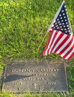
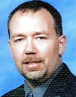
Dorlan Verle “Blackie” Carberry
| Birth | : | 11 Nov 1928 |
| Death | : | 15 Dec 1990 |
| Burial | : | Stafford Cemetery, Stafford, Stafford County, USA |
| Coordinate | : | 37.9536018, -98.6138992 |
| Description | : | Dorlan V. Carberry, 62, died Saturday at an Omaha hospital. Mr. Carberry was born in Bolan and was a World War II Army veteran. He worked for Union Pacific Railroad for 40 years as a mail handler and clerk. retiring in 1988. He is survived by his wife Ruth Carberry of Crescent; son Chris Carberry of Crescent; mother Tillie Carberry of Council Bluffs; sister, Elaine Mattox of Council Bluffs; four brothers, Leslie, Joseph, and Harley Carberry, all of Council Bluffs, and Gail Carberry of Crescent; and nieces and nephews. Funeral arrangements are pending at Beem-Belford... Read More |
frequently asked questions (FAQ):
-
Where is Dorlan Verle “Blackie” Carberry's memorial?
Dorlan Verle “Blackie” Carberry's memorial is located at: Stafford Cemetery, Stafford, Stafford County, USA.
-
When did Dorlan Verle “Blackie” Carberry death?
Dorlan Verle “Blackie” Carberry death on 15 Dec 1990 in
-
Where are the coordinates of the Dorlan Verle “Blackie” Carberry's memorial?
Latitude: 37.9536018
Longitude: -98.6138992
Family Members:
Parent
Spouse
Siblings
Children
Flowers:
Nearby Cemetories:
1. Verning Cemetery
Stafford, Stafford County, USA
Coordinate: 37.9986000, -98.6438980
2. Pleasant Valley Cemetery
Stafford, Stafford County, USA
Coordinate: 37.9253006, -98.5535965
3. Prairie Chapel Cemetery
Stafford County, USA
Coordinate: 37.8978004, -98.6493988
4. Leesburg Cemetery
Stafford County, USA
Coordinate: 37.8993988, -98.6913986
5. Strobel Cemetery
Stafford, Stafford County, USA
Coordinate: 38.0414009, -98.6007996
6. Feldhut Cemetery
Hudson, Stafford County, USA
Coordinate: 38.0415000, -98.6372600
7. Fairview Park Cemetery
St. John, Stafford County, USA
Coordinate: 38.0078380, -98.7456540
8. Martin Cemetery
St. John, Stafford County, USA
Coordinate: 37.9564018, -98.7742004
9. Rose Valley Cemetery
Stafford, Stafford County, USA
Coordinate: 37.8616982, -98.7285995
10. Old Neola Cemetery
Zenith, Stafford County, USA
Coordinate: 37.8377991, -98.4903030
11. Trinity Cemetery
Hudson, Stafford County, USA
Coordinate: 38.1048600, -98.6560400
12. Devore Family Cemetery
St. John, Stafford County, USA
Coordinate: 38.0141200, -98.7947700
13. Peace Creek Cemetery
Stafford, Stafford County, USA
Coordinate: 38.0635986, -98.4725037
14. Haynesville Cemetery
Preston, Pratt County, USA
Coordinate: 37.7916985, -98.5749969
15. Friendship Cemetery
Preston, Pratt County, USA
Coordinate: 37.7775002, -98.6200027
16. Glendale Cemetery
Reno County, USA
Coordinate: 37.9043999, -98.3981018
17. Sylvia Cemetery
Sylvia, Reno County, USA
Coordinate: 37.9561005, -98.3889008
18. Hayes Township Cemetery
Sylvia, Reno County, USA
Coordinate: 38.0451500, -98.4088600
19. Salem Cemetery
Hudson, Stafford County, USA
Coordinate: 38.1514015, -98.6399994
20. Hazen Cemetery
Sylvia, Reno County, USA
Coordinate: 37.9653015, -98.3617020
21. Pleasant Valley Cemetery
Preston, Pratt County, USA
Coordinate: 37.7757988, -98.4963989
22. Turon Cemetery
Turon, Reno County, USA
Coordinate: 37.7983017, -98.4464035
23. Neelands Cemetery
St. John, Stafford County, USA
Coordinate: 37.9000015, -98.8660965
24. Peace United Church of Christ Cemetery
Hudson, Stafford County, USA
Coordinate: 38.1591988, -98.6579971


