

Dorothy Alice Stevens Lucke
| Birth | : | 5 Feb 1909 Clinton, Clinton County, Iowa, USA |
| Death | : | 22 Nov 1986 |
| Burial | : | Puerto Rico National Cemetery, Bayamon, Bayamon Municipality, USA |
| Coordinate | : | 18.4109097, -66.1693268 |
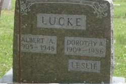
| Description | : | Dorothy Lucke (1909-1986) was widowed in 1948. She went to work at a toy factory, and then for 25 years at the Clinton Garment Company. She remarried, Isaac Leslie. She had at least one child, a daughter Diane Johnson. ~~~~~~~~~~~~~~~~~~~~~~~~~~~~~ "World War II significantly reduced the number of men in the civilian work force, and women around the country stepped into jobs traditionally reserved for men. Mrs. Dorothy Lucke (1909-86) was such a woman, and this color portrait of her has become emblematic of the era. She broke the "grease ceiling" by becoming an engine wiper, as indicated by her stained right... Read More |
frequently asked questions (FAQ):
-
Where is Dorothy Alice Stevens Lucke's memorial?
Dorothy Alice Stevens Lucke's memorial is located at: Puerto Rico National Cemetery, Bayamon, Bayamon Municipality, USA.
-
When did Dorothy Alice Stevens Lucke death?
Dorothy Alice Stevens Lucke death on 22 Nov 1986 in
-
Where are the coordinates of the Dorothy Alice Stevens Lucke's memorial?
Latitude: 18.4109097
Longitude: -66.1693268
Family Members:

Flowers:


Nearby Cemetories:
1. Cementerio Porta Coeli
Hato Tejas, Bayamon Municipality, USA
Coordinate: 18.4140450, -66.1721380
2. Cementerio Municipal Braulio Dueño Colón
Bayamon, Bayamon Municipality, USA
Coordinate: 18.3929400, -66.1608700
3. Cementerio y Mausoléo Barrio Palma
Las Palmas, Catano Municipality, USA
Coordinate: 18.4358130, -66.1543280
4. Los Angeles Memorial Park
Guaynabo, Guaynabo Municipality, USA
Coordinate: 18.3963450, -66.1214500
5. Cementerio Municipal
Bay View, Catano Municipality, USA
Coordinate: 18.4439080, -66.1326360
6. Cementerio Municipal Amelia
Amelia, Guaynabo Municipality, USA
Coordinate: 18.4330540, -66.1200940
7. Cementerio Los Cipreses
Bayamon, Bayamon Municipality, USA
Coordinate: 18.3558250, -66.1783380
8. Mausoleo Municipal Cemetery
Toa Baja, Toa Baja Municipality, USA
Coordinate: 18.4265370, -66.2292400
9. Cementerio Los Hermanos Memorial Park
Toa Alta Municipality, USA
Coordinate: 18.3930683, -66.2366714
10. Cementerio Nuevo Barrio Los Frailes
Guaynabo, Guaynabo Municipality, USA
Coordinate: 18.3685590, -66.1151280
11. Catedral de San Juan Bautista
San Juan, San Juan Municipality, USA
Coordinate: 18.4656070, -66.1179690
12. Cementerio Santa María Magdalena de Pazzis
San Juan, San Juan Municipality, USA
Coordinate: 18.4692410, -66.1199200
13. San Francisco de Asis
San Juan, San Juan Municipality, USA
Coordinate: 18.4663550, -66.1134620
14. Cementerio Municipal Viejo de Toa Alta
Toa Alta, Toa Alta Municipality, USA
Coordinate: 18.3882890, -66.2512600
15. Cementerio Historico de Guaynabo
Guaynabo, Guaynabo Municipality, USA
Coordinate: 18.3489400, -66.1082400
16. Cementerio Municipal
Toa Baja, Toa Baja Municipality, USA
Coordinate: 18.4455380, -66.2548220
17. Cementerio de la Capital
Puerto Nuevo, San Juan Municipality, USA
Coordinate: 18.3842810, -66.0724590
18. Cementerio Villa Nevárez
Rio Piedras, San Juan Municipality, USA
Coordinate: 18.3924500, -66.0638900
19. Parroquia San Vicente de Paul Criptas
San Juan, San Juan Municipality, USA
Coordinate: 18.4420270, -66.0653170
20. Cementerio Municipal de Río Piedras
Rio Piedras, San Juan Municipality, USA
Coordinate: 18.4017485, -66.0528151
21. Cementerio Municipal de Dorado
Dorado, Dorado Municipality, USA
Coordinate: 18.4640400, -66.2753490
22. Cementerio San José
San Juan, San Juan Municipality, USA
Coordinate: 18.4385570, -66.0498880
23. Buxeda Memorial Park
Rio Piedras, San Juan Municipality, USA
Coordinate: 18.3755675, -66.0480496
24. El Señorial Memorial Park
San Juan, San Juan Municipality, USA
Coordinate: 18.3446200, -66.0541130