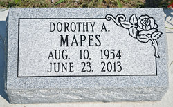
Dorothy Ann Warnke Mapes
| Birth | : | 10 Aug 1956 Ainsworth, Brown County, Nebraska, USA |
| Death | : | 23 Jun 2013 Ainsworth, Brown County, Nebraska, USA |
| Burial | : | Grandview Cemetery, Long Pine, Brown County, USA |
| Coordinate | : | 42.5251500, -99.7020000 |
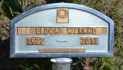
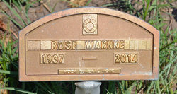
| Description | : | Dorothy Anne (Warnke) Mapes, age 58 went to be with her Father the Lord God, on Sunday June 23, 2013, at the Brown County Hospital in Ainsworth Nebraska, peacefully surrounded by her loving family. She was born to Eldon and Rosie(Seadore) Warnke on August 10, 1954 in Ainsworth. Married Dale Mapes Jr. on January 1, of 1976 at Ainsworth. She was a long time resident of Long Pine, Nebraska. We want to remember the life and vitality that was hers. Dorothy enjoyed life, accepted change, and looked forward to new experiences with enthusiasm and optimism. Her strong will to live,... Read More |
frequently asked questions (FAQ):
-
Where is Dorothy Ann Warnke Mapes's memorial?
Dorothy Ann Warnke Mapes's memorial is located at: Grandview Cemetery, Long Pine, Brown County, USA.
-
When did Dorothy Ann Warnke Mapes death?
Dorothy Ann Warnke Mapes death on 23 Jun 2013 in Ainsworth, Brown County, Nebraska, USA
-
Where are the coordinates of the Dorothy Ann Warnke Mapes's memorial?
Latitude: 42.5251500
Longitude: -99.7020000
Family Members:
Parent
Children
Flowers:
Nearby Cemetories:
1. Grandview Cemetery
Long Pine, Brown County, USA
Coordinate: 42.5251500, -99.7020000
2. Buffalo Flats Cemetery
Ainsworth, Brown County, USA
Coordinate: 42.5786700, -99.7357700
3. East Park Cemetery
Ainsworth, Brown County, USA
Coordinate: 42.5511017, -99.8244019
4. Bassett Memorial Park
Bassett, Rock County, USA
Coordinate: 42.5806007, -99.5768967
5. Ainsworth Cemetery
Ainsworth, Brown County, USA
Coordinate: 42.5341988, -99.8503036
6. Thurman Cemetery
Bassett, Rock County, USA
Coordinate: 42.4668999, -99.5591965
7. Keller Ranch Cemetery
Bassett, Rock County, USA
Coordinate: 42.4887000, -99.4838000
8. German Cemetery
Ainsworth, Brown County, USA
Coordinate: 42.5922012, -99.9103012
9. Grant Cemetery
Long Pine, Brown County, USA
Coordinate: 42.6944650, -99.6794000
10. Cuba Church Cemetery
Long Pine, Brown County, USA
Coordinate: 42.7101000, -99.6780000
11. Putnam Cemetery
Rock County, USA
Coordinate: 42.7080994, -99.6468964
12. Hulshizer Cemetery
Brown County, USA
Coordinate: 42.7219009, -99.7155991
13. Highland Grove Cemetery
Ainsworth, Brown County, USA
Coordinate: 42.6954000, -99.8530000
14. Brinckerhoff Cemetery
Bassett, Rock County, USA
Coordinate: 42.7302200, -99.6575700
15. Goodrich Cemetery
Riverview, Keya Paha County, USA
Coordinate: 42.7357760, -99.6875650
16. Leonard Cemetery
Keya Paha County, USA
Coordinate: 42.7358017, -99.6868973
17. Grand Prairie Cemetery
Brown County, USA
Coordinate: 42.5886002, -99.9894028
18. James Price Brown Cemetery
Keya Paha County, USA
Coordinate: 42.7246832, -99.5275883
19. East Woodlawn Cemetery
Johnstown, Brown County, USA
Coordinate: 42.5718994, -100.0382996
20. Highland Cemetery
Springview, Keya Paha County, USA
Coordinate: 42.7811012, -99.6650009
21. Rogers Cemetery
Springview, Keya Paha County, USA
Coordinate: 42.7961006, -99.7003021
22. Eureka Valley Cemetery
Rock County, USA
Coordinate: 42.4728012, -99.3392029
23. Woodlawn Cemetery
Johnstown, Brown County, USA
Coordinate: 42.5828018, -100.0736008
24. Newport Cemetery
Newport, Rock County, USA
Coordinate: 42.6077350, -99.3347410


