
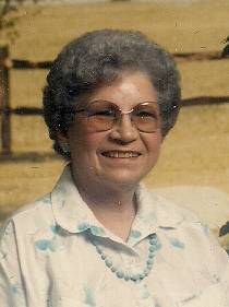
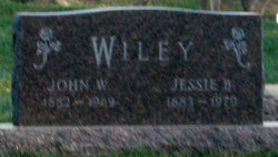
Dorothy Belle Wiley Davis
| Birth | : | 28 Feb 1924 Varina, Pocahontas County, Iowa, USA |
| Death | : | 7 Feb 2014 Spencer, Clay County, Iowa, USA |
| Burial | : | Riverside Cemetery, Spencer, Clay County, USA |
| Coordinate | : | 43.1441994, -95.1671982 |
| Description | : | Dorothy Belle Davis, the daughter of John and Jessie Wiley, was born February 28, 1924 in Varina, Iowa. Her childhood years were spent in the Varina, Storm Lake and Rembrandt areas where she received her education. Dorothy was united in marriage to Wayne Davis of Laurens on September 5, 1940 at the Methodist Parsonage in Emmetsburg. They farmed in the Laurens, Marathon, and Dickens area. She was a farm wife and spent many hours in the field helping her husband. They were blessed with two children: Sonja and Larry. They moved to Spencer in 1970 and were the owners of D&D... Read More |
frequently asked questions (FAQ):
-
Where is Dorothy Belle Wiley Davis's memorial?
Dorothy Belle Wiley Davis's memorial is located at: Riverside Cemetery, Spencer, Clay County, USA.
-
When did Dorothy Belle Wiley Davis death?
Dorothy Belle Wiley Davis death on 7 Feb 2014 in Spencer, Clay County, Iowa, USA
-
Where are the coordinates of the Dorothy Belle Wiley Davis's memorial?
Latitude: 43.1441994
Longitude: -95.1671982
Family Members:
Parent

Spouse
Siblings

Children
Flowers:


Nearby Cemetories:
1. Riverside Cemetery
Spencer, Clay County, USA
Coordinate: 43.1441994, -95.1671982
2. Dewey Readmore Books Memorial
Spencer, Clay County, USA
Coordinate: 43.1403999, -95.1443024
3. North Lawn Cemetery
Spencer, Clay County, USA
Coordinate: 43.1600000, -95.1470000
4. Evergreen Cemetery
Clay County, USA
Coordinate: 43.2052994, -95.2086029
5. Fairview Cemetery
Clay County, USA
Coordinate: 43.1899986, -95.0800018
6. Swedish Lutheran Cemetery
Royal, Clay County, USA
Coordinate: 43.0683000, -95.2350000
7. Dickens Cemetery
Dickens, Clay County, USA
Coordinate: 43.1280000, -95.0155000
8. Rosehill Cemetery
Clay County, USA
Coordinate: 43.0368996, -95.0919037
9. Lone Tree Cemetery
Everly, Clay County, USA
Coordinate: 43.1411018, -95.3347015
10. Little Sioux Lutheran Cemetery
Milford, Dickinson County, USA
Coordinate: 43.2702065, -95.2109528
11. First Reformed Cemetery
Clay County, USA
Coordinate: 43.2399500, -95.2889000
12. Lincoln Cemetery
Rossie, Clay County, USA
Coordinate: 43.0111008, -95.2313995
13. Willow Creek Cemetery
Royal, Clay County, USA
Coordinate: 43.0214005, -95.2885971
14. Liberty Cemetery
Greenville, Clay County, USA
Coordinate: 42.9897003, -95.1417007
15. Clay Center Cemetery
Royal, Clay County, USA
Coordinate: 43.0410995, -95.3272018
16. Milford Cemetery
Milford, Dickinson County, USA
Coordinate: 43.3092003, -95.1481018
17. TriMello Cemetery
Royal, Clay County, USA
Coordinate: 43.0682983, -95.3728027
18. Logan Township Cemetery
Clay County, USA
Coordinate: 43.0489006, -94.9747009
19. Zion Methodist Cemetery
Clay County, USA
Coordinate: 42.9808006, -95.2497025
20. Calvary Cemetery
Milford, Dickinson County, USA
Coordinate: 43.3213997, -95.1688995
21. Fanny Fern Cemetery
Clay County, USA
Coordinate: 42.9530983, -95.1607971
22. Crown Hill Cemetery
Ruthven, Palo Alto County, USA
Coordinate: 43.1328011, -94.8878021
23. Calvary Cemetery
Ruthven, Palo Alto County, USA
Coordinate: 43.1314011, -94.8869019
24. Westport Cemetery
Dickinson County, USA
Coordinate: 43.3130989, -95.3289032