
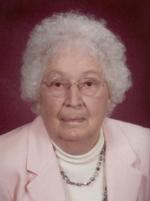
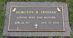
Dorothy Blanche Simon Trydahl
| Birth | : | 10 Apr 1917 Thompson, Grand Forks County, North Dakota, USA |
| Death | : | 25 Dec 2010 Grand Forks, Grand Forks County, North Dakota, USA |
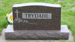
| Burial | : | Saint Marys Cemetery, Warroad, Roseau County, USA |
| Coordinate | : | 48.8880997, -95.3189011 |
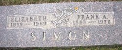
| Description | : | Dorothy B. Trydahl, 93, of Thompson, ND, passed away Saturday, December 25, 2010 in Valley Eldercare Center in Grand Forks, ND. Dorothy Blanche Simon was born April 10, 1917 in Thompson, ND, the daughter of Frank and Elizabeth (Ziegraf) Simon. She was baptized and confirmed in St. Jude's Parish in Thompson. She graduated from Thompson High School in 1935. Dorothy was united in marriage to Lars Trydahl on November 8, 1941 in Seattle, WA. After World War II, they returned to Thompson where they made their home and raised their 3 children. Lars preceded her in death on... Read More |
frequently asked questions (FAQ):
-
Where is Dorothy Blanche Simon Trydahl's memorial?
Dorothy Blanche Simon Trydahl's memorial is located at: Saint Marys Cemetery, Warroad, Roseau County, USA.
-
When did Dorothy Blanche Simon Trydahl death?
Dorothy Blanche Simon Trydahl death on 25 Dec 2010 in Grand Forks, Grand Forks County, North Dakota, USA
-
Where are the coordinates of the Dorothy Blanche Simon Trydahl's memorial?
Latitude: 48.8880997
Longitude: -95.3189011
Family Members:
Parent

Siblings

Flowers:


Nearby Cemetories:
1. Saint Marys Cemetery
Warroad, Roseau County, USA
Coordinate: 48.8880997, -95.3189011
2. Riverside Cemetery
Warroad, Roseau County, USA
Coordinate: 48.8911018, -95.3255997
3. Roundy Cemetery
Warroad, Roseau County, USA
Coordinate: 48.8795430, -95.3193910
4. Cherne Cugnet Cemetery
Roseau County, USA
Coordinate: 48.8998400, -95.3085800
5. Indian Burial Grounds
Warroad, Roseau County, USA
Coordinate: 48.9061080, -95.3269180
6. America Cemetery
Swift, Roseau County, USA
Coordinate: 48.7817001, -95.3786011
7. Norland Cemetery
Salol, Roseau County, USA
Coordinate: 48.9330500, -95.5053900
8. Mount Carmel Lutheran Church Cemetery
Chilgren Township, Lake of the Woods County, USA
Coordinate: 48.8866200, -95.0899300
9. Pine Ridge Cemetery
Roseau County, USA
Coordinate: 48.7360992, -95.2538986
10. Middlebro Community Cemetery
Middlebro, Eastern Manitoba Census Division, Canada
Coordinate: 49.0312000, -95.4318000
11. Silent City Cemetery
Roosevelt, Roseau County, USA
Coordinate: 48.8068000, -95.1007400
12. Gol Menighet Cemetery
Spruce Township, Roseau County, USA
Coordinate: 48.8485500, -95.6206900
13. Fairview Cemetery
Roseau County, USA
Coordinate: 48.8088989, -95.6136017
14. Falun Cemetery
Roseau County, USA
Coordinate: 48.7481003, -95.5594025
15. Prosper Township Cemetery
Birch Beach, Lake of the Woods County, USA
Coordinate: 48.8863450, -94.9375190
16. Saint Phillips Cemetery
Roseau County, USA
Coordinate: 48.7187700, -95.6091000
17. Beaver Cemetery
Roseau County, USA
Coordinate: 48.6986008, -95.5828018
18. Malung Cemetery
Roseau County, USA
Coordinate: 48.7841988, -95.6810989
19. Williams Catholic Cemetery
Williams, Lake of the Woods County, USA
Coordinate: 48.7644400, -94.9590900
20. Spruce Cemetery
Roseau, Roseau County, USA
Coordinate: 48.8511009, -95.7236023
21. Pine Hill Cemetery
Williams, Lake of the Woods County, USA
Coordinate: 48.7708015, -94.9441986
22. Sprague Cemetery
Sprague, Eastern Manitoba Census Division, Canada
Coordinate: 49.0528300, -95.6648600
23. Salem Cemetery
Malung, Roseau County, USA
Coordinate: 48.7192430, -95.6702550
24. Hillside Cemetery
Lake of the Woods County, USA
Coordinate: 48.8436012, -94.8822021