
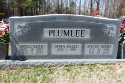
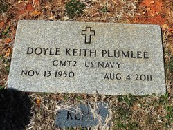
Doyle Keith Plumlee
| Birth | : | 13 Nov 1950 Clay County, Tennessee, USA |
| Death | : | 4 Aug 2011 Celina, Clay County, Tennessee, USA |
| Burial | : | Moss Cemetery, Moss, Clay County, USA |
| Coordinate | : | 36.5911210, -85.6214460 |
| Description | : | Doyle Keith Plumlee GAINESBORO -- Masonic services for Doyle Keith Plumlee, 60, of Gainesboro, will be held at 8 p.m. today, Friday, Aug. 5, and funeral services will be held at 11 a.m. on Saturday, Aug. 6, at Anderson-Upper Cumberland Funeral Home in Gainesboro. Burial will be in Moss Cemetery in Moss. The family will receive friends from 3-9 p.m. today and from 9 a.m. until time of services on Saturday at the funeral home. Mr. Plumlee died Thursday, Aug. 4, 2011, in Cumberland River Hospital in Celina. He was born November 13, 1950, in Clay County, TN, to Ina Mae Plumlee and... Read More |
frequently asked questions (FAQ):
-
Where is Doyle Keith Plumlee's memorial?
Doyle Keith Plumlee's memorial is located at: Moss Cemetery, Moss, Clay County, USA.
-
When did Doyle Keith Plumlee death?
Doyle Keith Plumlee death on 4 Aug 2011 in Celina, Clay County, Tennessee, USA
-
Where are the coordinates of the Doyle Keith Plumlee's memorial?
Latitude: 36.5911210
Longitude: -85.6214460
Family Members:
Parent

Siblings

Flowers:


Nearby Cemetories:
1. Moss Cemetery
Moss, Clay County, USA
Coordinate: 36.5911210, -85.6214460
2. Odle Cemetery
Clay County, USA
Coordinate: 36.5966988, -85.6085968
3. McLerran Cemetery
Moss, Clay County, USA
Coordinate: 36.5790000, -85.5973000
4. Moore Cemetery
Moss, Clay County, USA
Coordinate: 36.6113400, -85.6374980
5. Liberty Church Cemetery
Boles, Clay County, USA
Coordinate: 36.6010850, -85.6496830
6. Strong Family Cemetery
Clay County, USA
Coordinate: 36.5690700, -85.6042600
7. Kendall Cemetery
Moss, Clay County, USA
Coordinate: 36.5672540, -85.6362650
8. Spear Family Cemetery
Moss, Clay County, USA
Coordinate: 36.5933200, -85.5876500
9. Meadows Cemetery
Clay County, USA
Coordinate: 36.5946999, -85.5875015
10. Macedonia Cemetery
Moss, Clay County, USA
Coordinate: 36.5643997, -85.6110992
11. Willhoite-Curtis Cemetery
Tompkinsville, Monroe County, USA
Coordinate: 36.6182208, -85.6442948
12. Smith Cemetery
Pine Hill, Clay County, USA
Coordinate: 36.5714930, -85.6568170
13. Eads-Denton Cemetery
Pine Hill, Clay County, USA
Coordinate: 36.5644207, -85.6503187
14. Freedom Cemetery #2
Tompkinsville, Monroe County, USA
Coordinate: 36.6284060, -85.6289940
15. Moore Cemetery #1
Moss, Clay County, USA
Coordinate: 36.6164920, -85.6636620
16. New Hope Cemetery
Clay County, USA
Coordinate: 36.6021996, -85.5653000
17. Old Bob Wood Place Cemetery
Boles, Monroe County, USA
Coordinate: 36.6325120, -85.6515600
18. Pitcock Cemetery
Clay County, USA
Coordinate: 36.5992012, -85.6911011
19. Baxter Cemetery
Hestand, Monroe County, USA
Coordinate: 36.6501460, -85.6264790
20. Walker Reecer Cemetery
Celina, Clay County, USA
Coordinate: 36.5746290, -85.5480270
21. Beech Grove Cemetery
Harlan Crossroads, Monroe County, USA
Coordinate: 36.6319000, -85.6809000
22. Jonestown Cemetery
Clay County, USA
Coordinate: 36.5619011, -85.6921997
23. Bailey Cemetery
Tompkinsville, Monroe County, USA
Coordinate: 36.6530991, -85.5994034
24. Henson Cemetery
Hestand, Monroe County, USA
Coordinate: 36.6553740, -85.6310890