Dr Christopher Ribble
| Birth | : | 16 Nov 1742 Germany |
| Death | : | 15 Apr 1836 Blacksburg, Montgomery County, Virginia, USA |
| Burial | : | Newcastle Cemetery, Newcastle-under-Lyme, Newcastle-Under-Lyme Borough, England |
| Coordinate | : | 53.0062940, -2.2284440 |
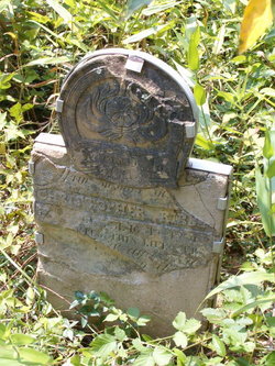
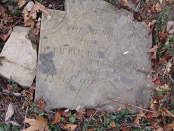
| Inscription | : | Christopher Ribble born Nov. 16, 1742 Departed this life Apr 1836 aged 93 yrs. More but stone is broken. |
| Description | : | Christopher first married Sibilla Magdalena Brockerhoff on 28 November 1770 in the "Evangelisch", Cleve, Rheinland, Prussia. Nothing further is know about Sibilla. Christopher from his second marriage, before 1776, was to Katrinka Brenchenhof, who died in December 1792 at Gills Creek, Franklin County, Virginia and they had 9 children: Magdalene, Hannah, Barbara, Elizabeth, Katherine, David, Mary, James (Jonas) and Susan. From his third marriage to Anna Karie Kegley on 7 February 1794, had 8 more children: Christopher, George, Philip, Leah, John, James, Henry and Sarah. These children all born at Gills Creek, Franklin County, Virginia. SEE daughter Madgalena (Ribble) Myers for the story of... Read More |
frequently asked questions (FAQ):
-
Where is Dr Christopher Ribble's memorial?
Dr Christopher Ribble's memorial is located at: Newcastle Cemetery, Newcastle-under-Lyme, Newcastle-Under-Lyme Borough, England.
-
When did Dr Christopher Ribble death?
Dr Christopher Ribble death on 15 Apr 1836 in Blacksburg, Montgomery County, Virginia, USA
-
Where are the coordinates of the Dr Christopher Ribble's memorial?
Latitude: 53.0062940
Longitude: -2.2284440
Family Members:
Spouse
Children
Flowers:
Nearby Cemetories:
1. Newcastle Cemetery
Newcastle-under-Lyme, Newcastle-Under-Lyme Borough, England
Coordinate: 53.0062940, -2.2284440
2. St. Giles' Churchyard
Newcastle-under-Lyme, Newcastle-Under-Lyme Borough, England
Coordinate: 53.0115110, -2.2301920
3. St. George's Churchyard
Newcastle-under-Lyme, Newcastle-Under-Lyme Borough, England
Coordinate: 53.0141190, -2.2242070
4. Hartshill Cemetery
Hartshill, Stoke-on-Trent Unitary Authority, England
Coordinate: 53.0054283, -2.2035301
5. Silverdale Cemetery
Silverdale, Newcastle-Under-Lyme Borough, England
Coordinate: 53.0135400, -2.2559520
6. St Thomas the Apostle Churchyard
Penkhull, Stoke-on-Trent Unitary Authority, England
Coordinate: 53.0004170, -2.1964040
7. Newcastle-Under-Lyme Knutton Cemetery
Newcastle-under-Lyme, Newcastle-Under-Lyme Borough, England
Coordinate: 53.0220500, -2.2495100
8. Etruria Methodist Church
Stoke-on-Trent, Stoke-on-Trent Unitary Authority, England
Coordinate: 53.0209680, -2.1985840
9. Quakers Burial Ground
Stoke-on-Trent, Stoke-on-Trent Unitary Authority, England
Coordinate: 53.0052870, -2.1881570
10. St Margaret Churchyard
Wolstanton, Newcastle-Under-Lyme Borough, England
Coordinate: 53.0296810, -2.2154990
11. Hanley Cemetery
Hanley, Stoke-on-Trent Unitary Authority, England
Coordinate: 53.0143330, -2.1863120
12. St. Peter ad Vincula Churchyard
Stoke-on-Trent, Stoke-on-Trent Unitary Authority, England
Coordinate: 53.0041250, -2.1812460
13. St Luke the Evangelist Churchyard
Silverdale, Newcastle-Under-Lyme Borough, England
Coordinate: 53.0170300, -2.2736770
14. St. Mark's Church Graveyard
Shelton, Stoke-on-Trent Unitary Authority, England
Coordinate: 53.0189000, -2.1820000
15. St. Matthias Churchyard
Hanford, Stoke-on-Trent Unitary Authority, England
Coordinate: 52.9812170, -2.1962980
16. Chesterton Cemetery
Newcastle-under-Lyme, Newcastle-Under-Lyme Borough, England
Coordinate: 53.0352240, -2.2500500
17. Keele Cemetery
Keele, Newcastle-Under-Lyme Borough, England
Coordinate: 53.0087192, -2.2813113
18. St John the Baptist Churchyard
Keele, Newcastle-Under-Lyme Borough, England
Coordinate: 53.0039410, -2.2848720
19. Sacred Heart Churchyard
Hanley, Stoke-on-Trent Unitary Authority, England
Coordinate: 53.0210590, -2.1737770
20. Britannia Stadium
Stoke-on-Trent, Stoke-on-Trent Unitary Authority, England
Coordinate: 52.9884070, -2.1754520
21. Holy Trinity Churchyard
Chesterton, Stratford-on-Avon District, England
Coordinate: 53.0418320, -2.2523770
22. St. John the Evangelist Churchyard
Hanley, Stoke-on-Trent Unitary Authority, England
Coordinate: 53.0280200, -2.1749590
23. Christ Church Churchyard
Fenton, Stoke-on-Trent Unitary Authority, England
Coordinate: 52.9977700, -2.1638600
24. St John the Baptist Churchyard
Burslem, Stoke-on-Trent Unitary Authority, England
Coordinate: 53.0425850, -2.1962510


