
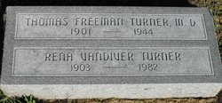
| Birth | : | 24 Oct 1901 Shelby County, Missouri, USA |
| Death | : | 28 Jun 1944 Macon, Macon County, Missouri, USA |
| Burial | : | Hanley Cemetery, Hanley, Stoke-on-Trent Unitary Authority, England |
| Coordinate | : | 53.0143330, -2.1863120 |
| Description | : | Occupation: Physician—M. D. MO d/c 21999 Prominent Macon Citizens Die at Lake Two prominent Macon citizens, Dr. T. F. Turner and Ermal White, proprietor of the White Drug Store, are dead as a result of a motor boat accident on the Macon Lake about 11 o'clock Wednesday night. The two men, Mrs. White, Miss Jean White, and Bennett Strong, son of Mr. and Mrs. Charles M. Strong, were occupants of a motor boat which capsized near the east side of the lake. Mrs. White, who could not swim, held to an empty gasoline can while Bennett Strong helped... Read More |
frequently asked questions (FAQ):
-
Where is Dr Thomas Freeman Turner's memorial?
Dr Thomas Freeman Turner's memorial is located at: Hanley Cemetery, Hanley, Stoke-on-Trent Unitary Authority, England.
-
When did Dr Thomas Freeman Turner death?
Dr Thomas Freeman Turner death on 28 Jun 1944 in Macon, Macon County, Missouri, USA
-
Where are the coordinates of the Dr Thomas Freeman Turner's memorial?
Latitude: 53.0143330
Longitude: -2.1863120
Family Members:
Parent
Spouse
Siblings

Flowers:


Nearby Cemetories:
1. Hanley Cemetery
Hanley, Stoke-on-Trent Unitary Authority, England
Coordinate: 53.0143330, -2.1863120
2. St. Mark's Church Graveyard
Shelton, Stoke-on-Trent Unitary Authority, England
Coordinate: 53.0189000, -2.1820000
3. Quakers Burial Ground
Stoke-on-Trent, Stoke-on-Trent Unitary Authority, England
Coordinate: 53.0052870, -2.1881570
4. Etruria Methodist Church
Stoke-on-Trent, Stoke-on-Trent Unitary Authority, England
Coordinate: 53.0209680, -2.1985840
5. Sacred Heart Churchyard
Hanley, Stoke-on-Trent Unitary Authority, England
Coordinate: 53.0210590, -2.1737770
6. St. Peter ad Vincula Churchyard
Stoke-on-Trent, Stoke-on-Trent Unitary Authority, England
Coordinate: 53.0041250, -2.1812460
7. Hartshill Cemetery
Hartshill, Stoke-on-Trent Unitary Authority, England
Coordinate: 53.0054283, -2.2035301
8. St Thomas the Apostle Churchyard
Penkhull, Stoke-on-Trent Unitary Authority, England
Coordinate: 53.0004170, -2.1964040
9. St. John the Evangelist Churchyard
Hanley, Stoke-on-Trent Unitary Authority, England
Coordinate: 53.0280200, -2.1749590
10. Holy Trinity Churchyard
Hanley, Stoke-on-Trent Unitary Authority, England
Coordinate: 53.0297350, -2.1672050
11. Christ Church Churchyard
Fenton, Stoke-on-Trent Unitary Authority, England
Coordinate: 52.9977700, -2.1638600
12. Fenton Cemetery
Fenton, Stoke-on-Trent Unitary Authority, England
Coordinate: 53.0022180, -2.1545860
13. St. George's Churchyard
Newcastle-under-Lyme, Newcastle-Under-Lyme Borough, England
Coordinate: 53.0141190, -2.2242070
14. St Margaret Churchyard
Wolstanton, Newcastle-Under-Lyme Borough, England
Coordinate: 53.0296810, -2.2154990
15. St. Giles' Churchyard
Newcastle-under-Lyme, Newcastle-Under-Lyme Borough, England
Coordinate: 53.0115110, -2.2301920
16. Newcastle Cemetery
Newcastle-under-Lyme, Newcastle-Under-Lyme Borough, England
Coordinate: 53.0062940, -2.2284440
17. Britannia Stadium
Stoke-on-Trent, Stoke-on-Trent Unitary Authority, England
Coordinate: 52.9884070, -2.1754520
18. St. Mary's Churchyard
Bucknall, Stoke-on-Trent Unitary Authority, England
Coordinate: 53.0240220, -2.1424430
19. St John the Baptist Churchyard
Burslem, Stoke-on-Trent Unitary Authority, England
Coordinate: 53.0425850, -2.1962510
20. Burslem Cemetery
Burslem, Stoke-on-Trent Unitary Authority, England
Coordinate: 53.0463020, -2.1747030
21. St. Matthias Churchyard
Hanford, Stoke-on-Trent Unitary Authority, England
Coordinate: 52.9812170, -2.1962980
22. Smallthorne Cemetery
Smallthorne, Stoke-on-Trent Unitary Authority, England
Coordinate: 53.0480310, -2.1765950
23. Abbey of St Mary
Abbey Hulton, Stoke-on-Trent Unitary Authority, England
Coordinate: 53.0200000, -2.1300000
24. Parish church of st saviour smallthorne
Smallthorne, Stoke-on-Trent Unitary Authority, England
Coordinate: 53.0497445, -2.1758707