
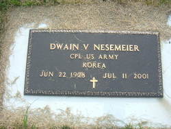
Dwain Virgil Nesemeier
| Birth | : | 22 Jun 1928 Leonard, Cass County, North Dakota, USA |
| Death | : | 11 Jul 2001 Barnesville, Clay County, Minnesota, USA |
| Burial | : | Grange Road Cemetery, Gillingham, Medway Unitary Authority, England |
| Coordinate | : | 51.3902512, 0.5639850 |
| Inscription | : | Cpl US Army Korea |
| Description | : | Dwain Virgil Nesemeier was born June 22, 1928 in Leonard, North Dakota. He attended school and farmed. He served in the U. S. Army from 1950 to 1952 during the Korean War. He returned to Leonard then moved with his family. |
frequently asked questions (FAQ):
-
Where is Dwain Virgil Nesemeier's memorial?
Dwain Virgil Nesemeier's memorial is located at: Grange Road Cemetery, Gillingham, Medway Unitary Authority, England.
-
When did Dwain Virgil Nesemeier death?
Dwain Virgil Nesemeier death on 11 Jul 2001 in Barnesville, Clay County, Minnesota, USA
-
Where are the coordinates of the Dwain Virgil Nesemeier's memorial?
Latitude: 51.3902512
Longitude: 0.5639850
Family Members:
Parent
Siblings
Flowers:


Nearby Cemetories:
1. Grange Road Cemetery
Gillingham, Medway Unitary Authority, England
Coordinate: 51.3902512, 0.5639850
2. St Mary Magdalene Churchyard
Gillingham, Medway Unitary Authority, England
Coordinate: 51.3903530, 0.5622230
3. Woodlands Cemetery
Gillingham, Medway Unitary Authority, England
Coordinate: 51.3839989, 0.5680000
4. St. Barnabas Church
Gillingham, Medway Unitary Authority, England
Coordinate: 51.3801400, 0.5505370
5. St. Augustine's Church
Gillingham, Medway Unitary Authority, England
Coordinate: 51.3745050, 0.5474930
6. St George Churchyard
Chatham, Medway Unitary Authority, England
Coordinate: 51.3974070, 0.5346770
7. Chatham Naval Memorial
Chatham, Medway Unitary Authority, England
Coordinate: 51.3836479, 0.5321670
8. Christ Church Cemetery
Chatham, Medway Unitary Authority, England
Coordinate: 51.3716730, 0.5462690
9. Brompton War Memorial
Chatham, Medway Unitary Authority, England
Coordinate: 51.3932140, 0.5293660
10. Chatham Burial Ground
Chatham, Medway Unitary Authority, England
Coordinate: 51.3849900, 0.5272600
11. St Mary Churchyard
Chatham, Medway Unitary Authority, England
Coordinate: 51.3874550, 0.5244280
12. St. Werburgh Churchyard
Hoo St Werburgh, Medway Unitary Authority, England
Coordinate: 51.4176500, 0.5634340
13. Chatham Unitarian Church
Chatham, Medway Unitary Authority, England
Coordinate: 51.3826090, 0.5195850
14. St Philip and St James Churchyard
Upnor, Medway Unitary Authority, England
Coordinate: 51.4106250, 0.5250480
15. Chatham Palmerston Road Cemetery
Chatham, Medway Unitary Authority, England
Coordinate: 51.3678600, 0.5267300
16. Chatham Maidstone Road Cemetery
Chatham, Medway Unitary Authority, England
Coordinate: 51.3703300, 0.5227600
17. Fort Pitt Military Cemetery
Rochester, Medway Unitary Authority, England
Coordinate: 51.3769790, 0.5114570
18. Rochester Baptist Church
Rochester, Medway Unitary Authority, England
Coordinate: 51.3871570, 0.5052370
19. All Saints Churchyard
Frindsbury, Medway Unitary Authority, England
Coordinate: 51.4004440, 0.5058970
20. St Nicholas Churchyard
Rochester, Medway Unitary Authority, England
Coordinate: 51.3894170, 0.5035320
21. Rochester Cathedral
Rochester, Medway Unitary Authority, England
Coordinate: 51.3889750, 0.5031160
22. Rochester Castle Moat Burial Ground
Rochester, Medway Unitary Authority, England
Coordinate: 51.3894140, 0.5024580
23. St Margaret Churchyard
Rainham, Medway Unitary Authority, England
Coordinate: 51.3629990, 0.6085000
24. St. Nicholas's Cemetery
Rochester, Medway Unitary Authority, England
Coordinate: 51.3780081, 0.5021076