
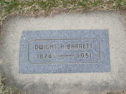
Dwight Albert Barrett
| Birth | : | 17 Oct 1874 McGregor, Clayton County, Iowa, USA |
| Death | : | 6 Nov 1951 Chelan, Chelan County, Washington, USA |
| Burial | : | Wessington Cemetery, Hand County, USA |
| Coordinate | : | 44.4569016, -98.7102966 |
| Plot | : | South Fraternal Row47 BLK46 LS5 |
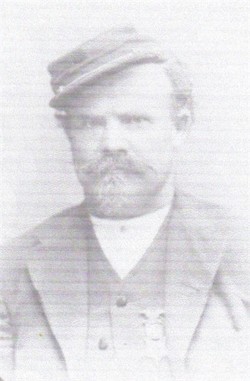
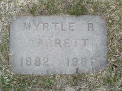
| Description | : | Funeral services for Dwight Albert Barrett, better known as "Captian Johnnie" when he fired steamboats on Lake Chelan and the Columbia River at the turn of the century, were held Friday. Born on October 17, 1874, at North McGregor, Iowa, he came to Waterville when 16 years old with his father and stepmother. They homesteaded in River precinct in Douglas Co., 19 miles north of Orondo. Mr. Barrett and Myrtle Haycox Barrett were married at Waterville on August, 13, 1910. Surviving are his widow, Myrtle Barrett of Chelan; two stepchildren, Cecil Barrett of Bremerton and Bonita Alder of Lakeside, two... Read More |
frequently asked questions (FAQ):
-
Where is Dwight Albert Barrett's memorial?
Dwight Albert Barrett's memorial is located at: Wessington Cemetery, Hand County, USA.
-
When did Dwight Albert Barrett death?
Dwight Albert Barrett death on 6 Nov 1951 in Chelan, Chelan County, Washington, USA
-
Where are the coordinates of the Dwight Albert Barrett's memorial?
Latitude: 44.4569016
Longitude: -98.7102966
Family Members:
Parent
Spouse
Siblings

Flowers:


Nearby Cemetories:
1. Wessington Cemetery
Hand County, USA
Coordinate: 44.4569016, -98.7102966
2. Saint Josephs Catholic Cemetery
Hand County, USA
Coordinate: 44.4574400, -98.7100400
3. McCord Cemetery
Wessington, Beadle County, USA
Coordinate: 44.3998500, -98.6673100
4. Sand Creek Cemetery
Beadle County, USA
Coordinate: 44.3055800, -98.6791200
5. Beulah Cemetery
Vayland, Hand County, USA
Coordinate: 44.6060982, -98.8060989
6. Saint Johns Lutheran Cemetery
Wolsey, Beadle County, USA
Coordinate: 44.3927994, -98.4985962
7. Rosehill Cemetery
Hand County, USA
Coordinate: 44.2980995, -98.7731018
8. Saint Lawrence Cemetery
Saint Lawrence, Hand County, USA
Coordinate: 44.5292015, -98.9321976
9. Wolsey Cemetery
Wolsey, Beadle County, USA
Coordinate: 44.4000015, -98.4546967
10. Saint Ann's Cemetery
Miller, Hand County, USA
Coordinate: 44.5222015, -98.9732971
11. G A R Cemetery
Miller, Hand County, USA
Coordinate: 44.5078011, -98.9858017
12. Bonilla Cemetery
Bonilla, Beadle County, USA
Coordinate: 44.5830994, -98.4835968
13. Molvig Cemetery
Virgil, Beadle County, USA
Coordinate: 44.2552900, -98.6145900
14. Hillcrest Cemetery
Miller, Hand County, USA
Coordinate: 44.5207000, -99.0006100
15. Garfield Cemetery
Spink County, USA
Coordinate: 44.6622009, -98.5535965
16. Buffalo Cemetery
Spink County, USA
Coordinate: 44.6918983, -98.6853027
17. Sunbeam Cemetery
Hand County, USA
Coordinate: 44.6777992, -98.8407974
18. Burdette Cemetery
Burdette, Hand County, USA
Coordinate: 44.7002983, -98.7869034
19. Earlville Cemetery
Beadle County, USA
Coordinate: 44.2118988, -98.6091995
20. Altoona Cemetery
Hitchcock, Beadle County, USA
Coordinate: 44.6108017, -98.4113998
21. New Zion Cemetery
Hand County, USA
Coordinate: 44.2043991, -98.8206024
22. Saint Johns Cemetery
Tulare, Spink County, USA
Coordinate: 44.7202988, -98.6600037
23. Virgil Cemetery
Virgil, Beadle County, USA
Coordinate: 44.2904800, -98.4176700
24. Broadland Catholic Cemetery
Broadland, Beadle County, USA
Coordinate: 44.5005000, -98.3380800