
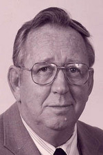
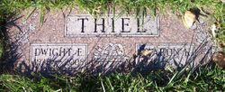
Dwight Elbert Thiel
| Birth | : | 3 May 1932 Henderson, Mills County, Iowa, USA |
| Death | : | 8 Feb 2008 Council Bluffs, Pottawattamie County, Iowa, USA |
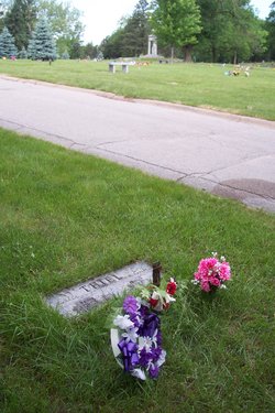
| Burial | : | Oak Hill Memorial Park, Escondido, San Diego County, USA |
| Coordinate | : | 33.1292000, -117.0271988 |
| Plot | : | Section C, Lot 103, Grave 2 |
| Description | : | Dwight E. Thiel, 75, of Council Bluffs, passed away Friday, February 8, 2008, at Mercy Hospital in Council Bluffs. Visitation will be 6:00 to 7:30 p.m., Monday, February 11, at Cutler-O'Neill-Meyer-Woodring Funeral Home, Council Bluffs. Memorials may be made to the American Cancer Society in his memory. Funeral services will follow the visitation at 7:30 p.m., Monday, February 11, at Cutler-O'Neill-Meyer-Woodring Funeral Home, Council Bluffs, with Rev. Dr. E. A. Hering officiating. Burial will be in Cedar Lawn Cemetery, Council Bluffs, Iowa, with Military Honors by American Legion Post #2. Dwight Elbert Thiel was born May 3,... Read More |
frequently asked questions (FAQ):
-
Where is Dwight Elbert Thiel's memorial?
Dwight Elbert Thiel's memorial is located at: Oak Hill Memorial Park, Escondido, San Diego County, USA.
-
When did Dwight Elbert Thiel death?
Dwight Elbert Thiel death on 8 Feb 2008 in Council Bluffs, Pottawattamie County, Iowa, USA
-
Where are the coordinates of the Dwight Elbert Thiel's memorial?
Latitude: 33.1292000
Longitude: -117.0271988
Family Members:
Parent

Spouse

Siblings
Flowers:


Nearby Cemetories:
1. Oak Hill Memorial Park
Escondido, San Diego County, USA
Coordinate: 33.1292000, -117.0271988
2. Community Lutheran Church Columbarium
Escondido, San Diego County, USA
Coordinate: 33.1597140, -117.0295190
3. Trinity Episcopal Church Columbarium
Escondido, San Diego County, USA
Coordinate: 33.1186300, -117.0699000
4. San Diego Zoo Safari Park
Escondido, San Diego County, USA
Coordinate: 33.0944900, -117.0024200
5. First United Methodist Church Columbarium
Escondido, San Diego County, USA
Coordinate: 33.1197710, -117.0786030
6. San Pasqual Indian Cemetery
San Pasqual, San Diego County, USA
Coordinate: 33.0923996, -116.9798965
7. San Pasquale Cemetery
Escondido, San Diego County, USA
Coordinate: 33.0938668, -116.9556266
8. San Pasqual Cemetery
San Pasqual, San Diego County, USA
Coordinate: 33.0943985, -116.9543991
9. San Marcos Cemetery
San Marcos, San Diego County, USA
Coordinate: 33.1598280, -117.1502850
10. Valley Center Cemetery
Valley Center, San Diego County, USA
Coordinate: 33.2388992, -117.0317001
11. Incarnation Lutheran Church Columbarium
Poway, San Diego County, USA
Coordinate: 33.0194200, -117.0510600
12. Rancho Bernardo Presbyterian Church Columbarium
Rancho Bernardo, San Diego County, USA
Coordinate: 33.0204391, -117.0612717
13. Grace Episcopal Church Cemetery
San Marcos, San Diego County, USA
Coordinate: 33.1433296, -117.1652832
14. Saint Bartholomew Episcopal Church Columbarium
Poway, San Diego County, USA
Coordinate: 33.0084830, -117.0557540
15. Valley Creek Farm Burial Site
Valley Center, San Diego County, USA
Coordinate: 33.2684790, -117.0123020
16. San Marcos Lutheran Church Columbarium
San Marcos, San Diego County, USA
Coordinate: 33.1479360, -117.2067170
17. Nuevo Memory Gardens
Ramona, San Diego County, USA
Coordinate: 33.0583200, -116.8640200
18. Dearborn Memorial Park
Poway, San Diego County, USA
Coordinate: 32.9738998, -117.0255966
19. Saint Bartholomew Cemetery
Rincon, San Diego County, USA
Coordinate: 33.2769012, -116.9468994
20. Meadowlark Pioneer Memorial Cemetery
San Marcos, San Diego County, USA
Coordinate: 33.1100998, -117.2253036
21. Meadowlark Community Church Columbarium
San Marcos, San Diego County, USA
Coordinate: 33.1122030, -117.2273590
22. Saint Francis Episcopal Church Memorial Garden
Pauma Valley, San Diego County, USA
Coordinate: 33.2956530, -116.9686810
23. Caskey-Campbell-Winfree-Smith Cemetery
Poway, San Diego County, USA
Coordinate: 32.9568500, -117.0031200
24. Church of The Nativity Columbarium
Rancho Santa Fe, San Diego County, USA
Coordinate: 32.9971120, -117.1978040