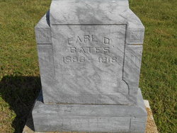
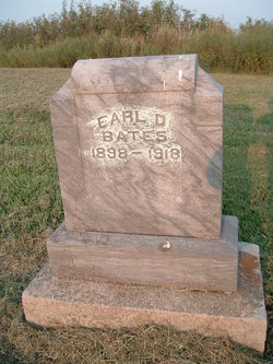
Earl Durison Bates
| Birth | : | 12 Dec 1898 Ray County, Missouri, USA |
| Death | : | 24 Oct 1918 Orrick, Ray County, Missouri, USA |
| Burial | : | Greenwich Presbyterian Church Cemetery, Greenwich, Cumberland County, USA |
| Coordinate | : | 39.4126200, -75.3459800 |
| Plot | : | Section 6 |
| Description | : | EARL BATES DEAD Earl Bates died at the home of his father-in-law, Mr. Henry Leake, north of Orrick, this afternoon at about 1 o'clock, from pneumonia following influencza. Deceased was a native of southwest Ray County, a son of Mr. and Mrs. Lon Bates and was abut 19 years old. He was united in marriage, June 10, of this year, to Miss Manilla Leake, who, with the parents, brothers and sisters, survive. He was a young man of exceptionally good morals, honest and industrious; and leaves many friends to mourn his loss and to sympathize with his relatives in their bereavement. Burial... Read More |
frequently asked questions (FAQ):
-
Where is Earl Durison Bates's memorial?
Earl Durison Bates's memorial is located at: Greenwich Presbyterian Church Cemetery, Greenwich, Cumberland County, USA.
-
When did Earl Durison Bates death?
Earl Durison Bates death on 24 Oct 1918 in Orrick, Ray County, Missouri, USA
-
Where are the coordinates of the Earl Durison Bates's memorial?
Latitude: 39.4126200
Longitude: -75.3459800
Family Members:
Spouse
Flowers:
Nearby Cemetories:
1. Greenwich Presbyterian Church Cemetery
Greenwich, Cumberland County, USA
Coordinate: 39.4126200, -75.3459800
2. Ambury Hill Cemetery
Cumberland County, USA
Coordinate: 39.4175491, -75.3496552
3. Greenwich Friends Meeting House Cemetery
Greenwich, Cumberland County, USA
Coordinate: 39.4066467, -75.3447189
4. Greenwich Friends Cemetery #02
Greenwich, Cumberland County, USA
Coordinate: 39.3997955, -75.3439865
5. Mount Pleasant Cemetery
Springtown, Cumberland County, USA
Coordinate: 39.4182663, -75.3290863
6. Othello Church Graveyard
Othello, Cumberland County, USA
Coordinate: 39.4182660, -75.3290860
7. Greenwich Baptist Church Cemetery
Greenwich, Cumberland County, USA
Coordinate: 39.3936310, -75.3417587
8. Old Cohansey Graveyard
Sheppards Mill, Cumberland County, USA
Coordinate: 39.4089432, -75.3111649
9. Cohansey Baptist Church Cemetery
Roadstown, Cumberland County, USA
Coordinate: 39.4388630, -75.3143070
10. Holly Corner Cemetery
Fairton, Cumberland County, USA
Coordinate: 39.3717303, -75.3308135
11. Shiloh Seventh Day Baptist Church Cemetery
Shiloh, Cumberland County, USA
Coordinate: 39.4591293, -75.2956696
12. Fernwood Memorial Park
Bridgeton, Cumberland County, USA
Coordinate: 39.4514008, -75.2844009
13. Cumberland County Memorial Cemetery
Bridgeton, Cumberland County, USA
Coordinate: 39.4125600, -75.2638800
14. Cedar Hill Memorial Park
Bridgeton, Cumberland County, USA
Coordinate: 39.4244003, -75.2647018
15. Cumberland County Veterans Cemetery
Bridgeton, Cumberland County, USA
Coordinate: 39.4105186, -75.2588959
16. Cuff Cemetery
Canton, Salem County, USA
Coordinate: 39.4649391, -75.4077988
17. Overlook Cemetery
Bridgeton, Cumberland County, USA
Coordinate: 39.4239006, -75.2536011
18. Marlboro Seventh Day Baptist Church Cemetery
Marlboro, Cumberland County, USA
Coordinate: 39.4899200, -75.3259500
19. Old Broad Street Presbyterian Church Cemetery
Bridgeton, Cumberland County, USA
Coordinate: 39.4295235, -75.2457123
20. Canton Baptist Church Cemetery
Canton, Salem County, USA
Coordinate: 39.4799385, -75.4120789
21. Cohanzick Zoo
Bridgeton, Cumberland County, USA
Coordinate: 39.4395510, -75.2388370
22. First Baptist Church Cemetery
Bridgeton, Cumberland County, USA
Coordinate: 39.4325638, -75.2298355
23. Old Presbyterian Cemetery
Fairton, Cumberland County, USA
Coordinate: 39.3758011, -75.2363968
24. First United Methodist Churchyard
Bridgeton, Cumberland County, USA
Coordinate: 39.4282417, -75.2277298


