

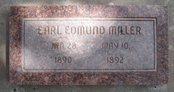
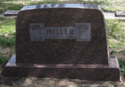
Earl Edmund Miller
| Birth | : | 28 Jan 1890 Rice County, Kansas, USA |
| Death | : | 10 May 1892 Rice County, Kansas, USA |
| Burial | : | Forest Home Cemetery, Rice County, USA |
| Coordinate | : | 38.5066986, -98.0171967 |
frequently asked questions (FAQ):
-
Where is Earl Edmund Miller's memorial?
Earl Edmund Miller's memorial is located at: Forest Home Cemetery, Rice County, USA.
-
When did Earl Edmund Miller death?
Earl Edmund Miller death on 10 May 1892 in Rice County, Kansas, USA
-
Where are the coordinates of the Earl Edmund Miller's memorial?
Latitude: 38.5066986
Longitude: -98.0171967
Family Members:
Parent

Siblings
Flowers:


Nearby Cemetories:
1. Forest Home Cemetery
Rice County, USA
Coordinate: 38.5066986, -98.0171967
2. Click Cemetery
Galt, Rice County, USA
Coordinate: 38.5186800, -98.0871200
3. Langley Cemetery
Langley, Ellsworth County, USA
Coordinate: 38.5508003, -97.9646988
4. Liscum Cemetery
Geneseo, Rice County, USA
Coordinate: 38.5144005, -98.1082993
5. Bean Cemetery
Little River, Rice County, USA
Coordinate: 38.4061012, -97.9972000
6. Geneseo Cemetery
Geneseo, Rice County, USA
Coordinate: 38.5069008, -98.1680984
7. Gile Family Cemetery
Kanopolis, Ellsworth County, USA
Coordinate: 38.6252810, -97.9523680
8. Riverside Cemetery
McPherson County, USA
Coordinate: 38.6030998, -97.9052963
9. Scates Cemetery
Ellsworth County, USA
Coordinate: 38.6194191, -98.1013031
10. Excelsior Cemetery
Marquette, McPherson County, USA
Coordinate: 38.4639015, -97.8522034
11. Elim Lutheran Cemetery
Marquette, McPherson County, USA
Coordinate: 38.5586930, -97.8426660
12. Marquette Cemetery
Marquette, McPherson County, USA
Coordinate: 38.5667000, -97.8360977
13. Buckeye Cemetery
Kanopolis, Ellsworth County, USA
Coordinate: 38.6514664, -98.1110001
14. Windom Cemetery
Windom, McPherson County, USA
Coordinate: 38.3842010, -97.8694000
15. Fairview Cemetery
McPherson County, USA
Coordinate: 38.4389000, -97.8058014
16. Stephens Cemetery
McPherson, McPherson County, USA
Coordinate: 38.5395430, -97.7921990
17. Frederick Cemetery
Frederick, Rice County, USA
Coordinate: 38.5077350, -98.2484450
18. Spencer Cemetery
Saline County, USA
Coordinate: 38.6191500, -97.8343700
19. Old Dunkard Cemetery
Rice County, USA
Coordinate: 38.3549200, -98.1455480
20. Union Cemetery
Little River, Rice County, USA
Coordinate: 38.3260650, -97.9615720
21. Freemount Lutheran Church Cemetery
Freemount, McPherson County, USA
Coordinate: 38.5395730, -97.7777520
22. Lodiana Cemetery
Lyons, Rice County, USA
Coordinate: 38.3177986, -98.0627975
23. Summit Cemetery
Saline County, USA
Coordinate: 38.6741982, -97.8886032
24. Shumway Cemetery
Lyons, Rice County, USA
Coordinate: 38.3911018, -98.2356033