
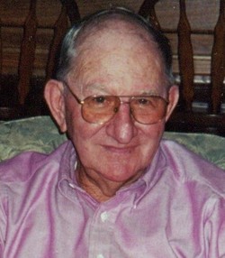
Earl Edward “Bud” Rutledge
| Birth | : | 7 Feb 1931 Shannon County, Missouri, USA |
| Death | : | 6 Feb 2011 Springfield, Greene County, Missouri, USA |
| Burial | : | Glenwood City Cemetery, Glenwood, Pope County, USA |
| Coordinate | : | 45.6360728, -95.3805909 |
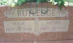
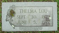
| Description | : | Earl Eward "Bud" Rutledge went home to be with his Lord and Savior on Sunday,February 6,2011,in St.John's Mercy Hospital,after suffering heart complications.Bud was born in Aden Springs,south of Birch Tree,Missouri,on February 7,1931.He was the second child of Luther"Bunt" and Dessie Spaulding Rutledge.He was united in marriage to the love of his life,Thelma Lou McHenery,in January 1950.To this union,two daughters were born.Bud was a very personal,loving and caring individual who always put the need of others before himself.He dedicated his life to serving others in his community.He served on the Oak Forest Cemetery Board and Road District Board. He began... Read More |
frequently asked questions (FAQ):
-
Where is Earl Edward “Bud” Rutledge's memorial?
Earl Edward “Bud” Rutledge's memorial is located at: Glenwood City Cemetery, Glenwood, Pope County, USA.
-
When did Earl Edward “Bud” Rutledge death?
Earl Edward “Bud” Rutledge death on 6 Feb 2011 in Springfield, Greene County, Missouri, USA
-
Where are the coordinates of the Earl Edward “Bud” Rutledge's memorial?
Latitude: 45.6360728
Longitude: -95.3805909
Family Members:
Parent

Spouse
Siblings


Nearby Cemetories:
1. Glenwood City Cemetery
Glenwood, Pope County, USA
Coordinate: 45.6360728, -95.3805909
2. Glenwood Lutheran Cemetery
Glenwood, Pope County, USA
Coordinate: 45.6361008, -95.3803024
3. Calvary Cemetery
Glenwood, Pope County, USA
Coordinate: 45.6349983, -95.3807983
4. Princess Minnewaska Burial Mound
Glenwood, Pope County, USA
Coordinate: 45.6578770, -95.4380920
5. Barsness Lutheran Cemetery
Pope County, USA
Coordinate: 45.5788889, -95.4069444
6. West Lake Amelia Cemetery
Villard, Pope County, USA
Coordinate: 45.6657982, -95.3031006
7. Lake Ann Cemetery
Long Beach, Pope County, USA
Coordinate: 45.6955986, -95.4285965
8. Saint Johns Lutheran Cemetery
Villard, Pope County, USA
Coordinate: 45.6861000, -95.3035965
9. Lake Reno Reformed Presbyterian Cemetery
Pope County, USA
Coordinate: 45.7155991, -95.4261017
10. Lake Ben Cemetery
Pope County, USA
Coordinate: 45.5469017, -95.3961029
11. Old Yankee Cemetery
Pope County, USA
Coordinate: 45.6436210, -95.5099760
12. Calvary Cemetery
Villard, Pope County, USA
Coordinate: 45.6931000, -95.2636032
13. Lake Amelia Cemetery
Villard, Pope County, USA
Coordinate: 45.6941986, -95.2636032
14. Fron Cemetery
Starbuck, Pope County, USA
Coordinate: 45.5849991, -95.5100021
15. Reno Mission Cemetery
Lowry, Pope County, USA
Coordinate: 45.7125015, -95.4824982
16. Immaculate Conception Cemetery
Sedan, Pope County, USA
Coordinate: 45.5786018, -95.2538986
17. Indherred Lutheran Church Cemetery
Starbuck, Pope County, USA
Coordinate: 45.6559500, -95.5307200
18. Oak Hill Cemetery
Lowry, Pope County, USA
Coordinate: 45.7125015, -95.4886017
19. Adams Cemetery
Villard, Pope County, USA
Coordinate: 45.7121700, -95.2629700
20. Minnewaska Lutheran Cemetery
Starbuck, Pope County, USA
Coordinate: 45.6142006, -95.5438995
21. Lake Leven Cemetery
Villard, Pope County, USA
Coordinate: 45.7327995, -95.2750015
22. Saint John Nepomuk Catholic Church Cemetery
Lowry, Pope County, USA
Coordinate: 45.7452160, -95.4693890
23. Chippewa Falls Cemetery
Pope County, USA
Coordinate: 45.5131080, -95.3182660
24. Bohemian Independent Cemetery
Douglas County, USA
Coordinate: 45.7599983, -95.4428024