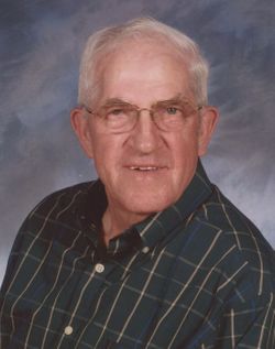
Earl Robert “Bob” Dodge
| Birth | : | 2 Nov 1930 Oakland, Garrett County, Maryland, USA |
| Death | : | 8 Jan 2019 Oakland, Garrett County, Maryland, USA |
| Burial | : | Saint Johns Lutheran Church Cemetery, Redhouse, Garrett County, USA |
| Coordinate | : | 39.3101501, -79.4530029 |
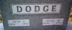
| Description | : | OAKLAND — Earl Robert “Bob” Dodge, 88, Oakland, passed away on Tuesday, Jan. 8, 2019, at Mon Health Medical Center in Morgantown, W.Va. Born on Nov. 2, 1930, in Oakland, he was the son of the late Artie and Hazel (Mosser) Dodge. Bob was a graduate of Oakland High School and a member of St. John’s Evangelical Lutheran Church. He followed in the footsteps of his family and was a third-generation dairy farmer. Bob was a strong, hard-working man with a gentle soul. He enjoyed farming and shared his passion of the land and the cows with... Read More |
frequently asked questions (FAQ):
-
Where is Earl Robert “Bob” Dodge's memorial?
Earl Robert “Bob” Dodge's memorial is located at: Saint Johns Lutheran Church Cemetery, Redhouse, Garrett County, USA.
-
When did Earl Robert “Bob” Dodge death?
Earl Robert “Bob” Dodge death on 8 Jan 2019 in Oakland, Garrett County, Maryland, USA
-
Where are the coordinates of the Earl Robert “Bob” Dodge's memorial?
Latitude: 39.3101501
Longitude: -79.4530029
Family Members:
Parent
Spouse
Flowers:
Nearby Cemetories:
1. Saint Johns Lutheran Church Cemetery
Redhouse, Garrett County, USA
Coordinate: 39.3101501, -79.4530029
2. Wolfe Cemetery
Redhouse, Garrett County, USA
Coordinate: 39.3122700, -79.4760500
3. Rinehart Cemetery
Oakland, Garrett County, USA
Coordinate: 39.3359400, -79.4551800
4. Dawson Cemetery
Eglon, Preston County, USA
Coordinate: 39.3157640, -79.4917690
5. Old Orphans Cemetery
Eglon, Preston County, USA
Coordinate: 39.2890028, -79.4940694
6. Wilt Cemetery
Aurora, Preston County, USA
Coordinate: 39.3196500, -79.5050600
7. Gnegy Church Cemetery
Redhouse, Garrett County, USA
Coordinate: 39.2769012, -79.4863968
8. Beckman Cemetery
Garrett County, USA
Coordinate: 39.3293991, -79.4000015
9. Gortner Cemetery
Gortner, Garrett County, USA
Coordinate: 39.3530998, -79.4272003
10. Eglon Community Cemetery
Eglon, Preston County, USA
Coordinate: 39.3000984, -79.5139771
11. Schlabach Cemetery
Gortner, Garrett County, USA
Coordinate: 39.3482800, -79.4117000
12. Maple Spring Cemetery
Eglon, Preston County, USA
Coordinate: 39.2867012, -79.5102997
13. Fairview Cemetery
Oakland, Garrett County, USA
Coordinate: 39.2703018, -79.4124985
14. Old Eglon Cemetery
Eglon, Preston County, USA
Coordinate: 39.3007622, -79.5188522
15. Underwood Cemetery
Oakland, Garrett County, USA
Coordinate: 39.3655800, -79.4653900
16. Brookside Cemetery
Aurora, Preston County, USA
Coordinate: 39.3244503, -79.5308788
17. Moreland Cemetery
Garrett County, USA
Coordinate: 39.2952995, -79.3703003
18. Lower Cemetery
Oakland, Garrett County, USA
Coordinate: 39.3716890, -79.4179470
19. Ashby Cemetery
Crellin, Garrett County, USA
Coordinate: 39.3774986, -79.4749985
20. Accident Community Cemetery
Horse Shoe Run, Preston County, USA
Coordinate: 39.2853012, -79.5406036
21. Texas Cemetery
Horse Shoe Run, Preston County, USA
Coordinate: 39.2651670, -79.5270690
22. Dobbin Cemetery
Garrett County, USA
Coordinate: 39.2421425, -79.4159961
23. James M Wilkins Cemetery
Dobbin, Grant County, USA
Coordinate: 39.2388734, -79.4154218
24. Oak Grove Cemetery
Gorman, Garrett County, USA
Coordinate: 39.3147011, -79.3531036


