
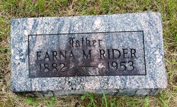
Earna Monroe Rider
| Birth | : | 27 Jan 1882 Carroll, Carroll County, Iowa, USA |
| Death | : | 27 Nov 1953 Springfield, Lane County, Oregon, USA |
| Burial | : | Dillavou Cemetery, Kendrick Township, Greene County, USA |
| Coordinate | : | 42.0802994, -94.6138992 |
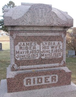
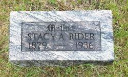
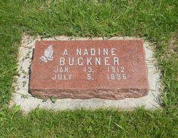
| Description | : | Ernie was the son of James and Lydia Rider. He married Stacy Dillavou on June 25, 1902 at Scranton, IA. They were the parents of 5 children: Leotha, Alfred, Nadine, and 2 sons who died in infancy. Jefferson Bee - Tuesday, December 17, 1953 - Funeral services for Earna M. 'Ernie' Rider, father of Mrs. Virgil (Nadine ) Buckner of Scranton, were held in the Friends church in Kendrick twp. Wednesday, Dec. 2, with Rev. John Biatto, pastor, officiating. Mrs. E.T. Christensen, accompanied by Mrs. Allen Mosier on the piano, sang "Sometime We'll Understand" and "No Night There." Funeral arrangements were... Read More |
frequently asked questions (FAQ):
-
Where is Earna Monroe Rider's memorial?
Earna Monroe Rider's memorial is located at: Dillavou Cemetery, Kendrick Township, Greene County, USA.
-
When did Earna Monroe Rider death?
Earna Monroe Rider death on 27 Nov 1953 in Springfield, Lane County, Oregon, USA
-
Where are the coordinates of the Earna Monroe Rider's memorial?
Latitude: 42.0802994
Longitude: -94.6138992
Family Members:
Parent

Spouse
Siblings
Children

Flowers:


Nearby Cemetories:
1. Dillavou Cemetery
Kendrick Township, Greene County, USA
Coordinate: 42.0802994, -94.6138992
2. Scranton Township Cemetery
Scranton, Greene County, USA
Coordinate: 42.0306015, -94.5783005
3. North Coon Cemetery
Carroll County, USA
Coordinate: 42.1260986, -94.6716995
4. Dickson Cemetery
Glidden Township, Carroll County, USA
Coordinate: 42.1074982, -94.6939011
5. Saint Patricks Cemetery
Churdan, Greene County, USA
Coordinate: 42.1605988, -94.5511017
6. Gibson-Fleck-Thompson Cemetery
Scranton, Greene County, USA
Coordinate: 42.0428870, -94.4988800
7. West Lawn Cemetery
Glidden, Carroll County, USA
Coordinate: 42.0649986, -94.7406006
8. Old Cedar Cemetery
Adaza, Greene County, USA
Coordinate: 42.1874821, -94.5419194
9. Highland Township Cemetery
Churdan, Greene County, USA
Coordinate: 42.1518310, -94.4699120
10. Lanesboro Cemetery
Lanesboro, Carroll County, USA
Coordinate: 42.1810989, -94.7230988
11. Holy Family Cemetery
Lidderdale, Carroll County, USA
Coordinate: 42.1178017, -94.7839966
12. Fair Oaks Cemetery
Scranton, Greene County, USA
Coordinate: 42.0355988, -94.4460983
13. Wright Cemetery
Jefferson, Greene County, USA
Coordinate: 42.0228004, -94.4477997
14. East Liberty Cemetery
Lidderdale, Carroll County, USA
Coordinate: 42.1591988, -94.7636032
15. Bishop Cemetery
Calhoun Township, Calhoun County, USA
Coordinate: 42.2230400, -94.6453190
16. Immanuel Cemetery
Lidderdale, Carroll County, USA
Coordinate: 42.1389008, -94.8022003
17. Headley Cemetery
Jefferson, Greene County, USA
Coordinate: 42.0041504, -94.4335815
18. Willow Cemetery
Greene County, USA
Coordinate: 41.9067001, -94.5730972
19. McCurdy Cemetery
Carroll County, USA
Coordinate: 41.9403000, -94.7649994
20. Saint Joseph Cemetery
Jefferson, Greene County, USA
Coordinate: 42.0289001, -94.3818970
21. Evergreen Cemetery
Lohrville, Calhoun County, USA
Coordinate: 42.2505989, -94.5330963
22. Old Carrollton Cemetery
Carrollton, Carroll County, USA
Coordinate: 41.9233017, -94.7403030
23. Carroll City Cemetery
Carroll, Carroll County, USA
Coordinate: 42.0560963, -94.8599856
24. Mount Olivet Cemetery
Carroll, Carroll County, USA
Coordinate: 42.0536340, -94.8595510