
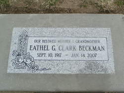


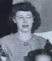
Eathel Gertrude Fels Beckman
| Birth | : | 10 Sep 1917 Chelan, Chelan County, Washington, USA |
| Death | : | 14 Jan 2007 Entiat, Chelan County, Washington, USA |
| Burial | : | Wessington Cemetery, Hand County, USA |
| Coordinate | : | 44.4569016, -98.7102966 |
| Plot | : | South Fraternal Row36 STBLK35 N5 |
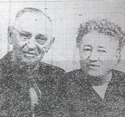
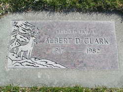
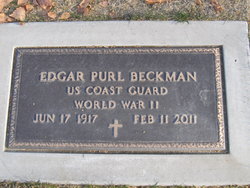
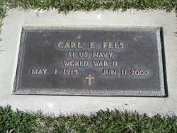
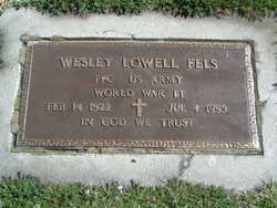
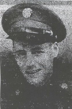
| Description | : | EATHEL CLARK BECKMAN - Thursday - January 18, 2007 Chelan - Eathel Clark Beckman, 89, of Chelan, died Sunday, January 14, 2007, at Bell's House and Home in Entiat. She was born September 10, 1917, at Chelan, the daughter of Carl and Ethel Mae (Story) Fels. She attended school in Manson, graduating from Manson High School. On July 2, 1938, she was married to Albert D. Clark. They made their home in Chelan until World War II, when they worked in the shipyards. They lived for a short time in Redding, CA before returning to Chelan. Her husband preceded her... Read More |
frequently asked questions (FAQ):
-
Where is Eathel Gertrude Fels Beckman's memorial?
Eathel Gertrude Fels Beckman's memorial is located at: Wessington Cemetery, Hand County, USA.
-
When did Eathel Gertrude Fels Beckman death?
Eathel Gertrude Fels Beckman death on 14 Jan 2007 in Entiat, Chelan County, Washington, USA
-
Where are the coordinates of the Eathel Gertrude Fels Beckman's memorial?
Latitude: 44.4569016
Longitude: -98.7102966
Family Members:
Parent

Spouse
Siblings

Children
Flowers:


Nearby Cemetories:
1. Wessington Cemetery
Hand County, USA
Coordinate: 44.4569016, -98.7102966
2. Saint Josephs Catholic Cemetery
Hand County, USA
Coordinate: 44.4574400, -98.7100400
3. McCord Cemetery
Wessington, Beadle County, USA
Coordinate: 44.3998500, -98.6673100
4. Sand Creek Cemetery
Beadle County, USA
Coordinate: 44.3055800, -98.6791200
5. Beulah Cemetery
Vayland, Hand County, USA
Coordinate: 44.6060982, -98.8060989
6. Saint Johns Lutheran Cemetery
Wolsey, Beadle County, USA
Coordinate: 44.3927994, -98.4985962
7. Rosehill Cemetery
Hand County, USA
Coordinate: 44.2980995, -98.7731018
8. Saint Lawrence Cemetery
Saint Lawrence, Hand County, USA
Coordinate: 44.5292015, -98.9321976
9. Wolsey Cemetery
Wolsey, Beadle County, USA
Coordinate: 44.4000015, -98.4546967
10. Saint Ann's Cemetery
Miller, Hand County, USA
Coordinate: 44.5222015, -98.9732971
11. G A R Cemetery
Miller, Hand County, USA
Coordinate: 44.5078011, -98.9858017
12. Bonilla Cemetery
Bonilla, Beadle County, USA
Coordinate: 44.5830994, -98.4835968
13. Molvig Cemetery
Virgil, Beadle County, USA
Coordinate: 44.2552900, -98.6145900
14. Hillcrest Cemetery
Miller, Hand County, USA
Coordinate: 44.5207000, -99.0006100
15. Garfield Cemetery
Spink County, USA
Coordinate: 44.6622009, -98.5535965
16. Buffalo Cemetery
Spink County, USA
Coordinate: 44.6918983, -98.6853027
17. Sunbeam Cemetery
Hand County, USA
Coordinate: 44.6777992, -98.8407974
18. Burdette Cemetery
Burdette, Hand County, USA
Coordinate: 44.7002983, -98.7869034
19. Earlville Cemetery
Beadle County, USA
Coordinate: 44.2118988, -98.6091995
20. Altoona Cemetery
Hitchcock, Beadle County, USA
Coordinate: 44.6108017, -98.4113998
21. New Zion Cemetery
Hand County, USA
Coordinate: 44.2043991, -98.8206024
22. Saint Johns Cemetery
Tulare, Spink County, USA
Coordinate: 44.7202988, -98.6600037
23. Virgil Cemetery
Virgil, Beadle County, USA
Coordinate: 44.2904800, -98.4176700
24. Broadland Catholic Cemetery
Broadland, Beadle County, USA
Coordinate: 44.5005000, -98.3380800