
Ebenezer Smead
| Birth | : | 9 May 1674 Deerfield, Franklin County, Massachusetts, USA |
| Death | : | 19 Jul 1753 Deerfield, Franklin County, Massachusetts, USA |
| Burial | : | Mohicanville Cemetery, Mohicanville, Ashland County, USA |
| Coordinate | : | 40.7265830, -82.1840700 |
| Plot | : | 47 |
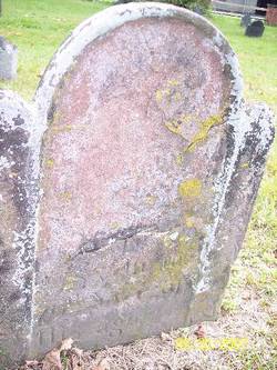
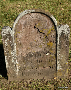
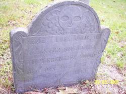
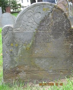
| Description | : | Ebenezer is the son of William Smead and Elizabeth Lawrence. He married Esther Catlin in 1694. They were the parents of Ebenezer, Esther, Elizabeth, Thankful, Ruth, Ebenezer, Jonathan, Joseph, and Abigail. Inscription: "Ebenezer Smead died July 19, 1753 in the 79th year of his age" |
frequently asked questions (FAQ):
-
Where is Ebenezer Smead's memorial?
Ebenezer Smead's memorial is located at: Mohicanville Cemetery, Mohicanville, Ashland County, USA.
-
When did Ebenezer Smead death?
Ebenezer Smead death on 19 Jul 1753 in Deerfield, Franklin County, Massachusetts, USA
-
Where are the coordinates of the Ebenezer Smead's memorial?
Latitude: 40.7265830
Longitude: -82.1840700
Family Members:
Parent
Spouse
Siblings


Children
Flowers:


Nearby Cemetories:
1. Mohicanville Cemetery
Mohicanville, Ashland County, USA
Coordinate: 40.7265830, -82.1840700
2. County Line Cemetery
Ashland County, USA
Coordinate: 40.7181015, -82.2221985
3. Pioneer Cemetery
Loudonville, Ashland County, USA
Coordinate: 40.6952800, -82.1637400
4. Scenic Ridge Mennonite Church Cemetery
Jeromesville, Ashland County, USA
Coordinate: 40.7619210, -82.1825330
5. Saint John Cemetery
McZena, Ashland County, USA
Coordinate: 40.6968900, -82.1524700
6. Lake Fork Cemetery
Lake Fork, Ashland County, USA
Coordinate: 40.7539500, -82.1457200
7. Synagogue-Church of God Cemetery
Hayesville, Ashland County, USA
Coordinate: 40.7475500, -82.2403500
8. McKay Cemetery
Hayesville, Ashland County, USA
Coordinate: 40.7044487, -82.2457809
9. Sunset Cemetery
Ashland County, USA
Coordinate: 40.7117004, -82.2506027
10. Fairview Cemetery
Craigton, Wayne County, USA
Coordinate: 40.7251015, -82.1067963
11. Bethesda Cemetery
Ashland County, USA
Coordinate: 40.7125015, -82.2600021
12. Bushnell Cemetery
Hayesville, Ashland County, USA
Coordinate: 40.7771988, -82.2414017
13. Pleasant View Cemetery
Wayne County, USA
Coordinate: 40.7771988, -82.1200027
14. Vermillion Cemetery
Hayesville, Ashland County, USA
Coordinate: 40.7691994, -82.2611008
15. Daubert Cemetery
Holmes County, USA
Coordinate: 40.6552140, -82.2015490
16. Plum Run Cemetery
Washington Township, Holmes County, USA
Coordinate: 40.6547821, -82.2015461
17. Jeromesville Cemetery
Jeromesville, Ashland County, USA
Coordinate: 40.8003500, -82.1940900
18. Newkirk Cemetery
Shreve, Wayne County, USA
Coordinate: 40.6823006, -82.1017990
19. Methodist Church Cemetery
Jeromesville, Ashland County, USA
Coordinate: 40.8053350, -82.1946010
20. Shriver Cemetery
Ashland County, USA
Coordinate: 40.7302590, -82.2927550
21. Eckley Cemetery
Jeromesville, Ashland County, USA
Coordinate: 40.8011017, -82.2403030
22. Blachleyville Cemetery
Blachleyville, Wayne County, USA
Coordinate: 40.7703018, -82.0843964
23. Saint Peters Cemetery
Loudonville, Ashland County, USA
Coordinate: 40.6455500, -82.2295000
24. McCrory Cemetery
Ashland County, USA
Coordinate: 40.7703705, -82.2892303